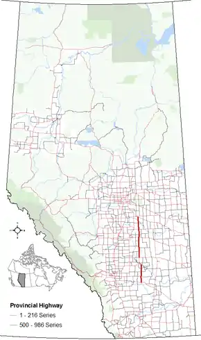
Alberta Highway 56
Alberta Provincial Highway No. 56, commonly referred to as Highway 56, is a north-south highway in central Alberta, Canada. It begins 20 km (12 mi) northwest of Bassano at its intersection with Highway 1 (Trans-Canada Highway). It continues through Drumheller and Stettler and before ending at intersection with Highway 13 and Highway 834 9 km (6 mi) southeast of Camrose.[2]
| ||||
|---|---|---|---|---|
 | ||||
| Route information | ||||
| Length | 245.6 km[1] (152.6 mi) | |||
| Major junctions | ||||
| South end | ||||
| North end | ||||
| Location | ||||
| Specialized and rural municipalities | Wheatland County, Starland County, Stettler No. 6 County, Camrose County | |||
| Towns | Stettler, Drumheller | |||
| Highway system | ||||
Provincial highways in Alberta
| ||||

History
Intersection of Highway 56 and Highway 10
In the early 1990s, there was talk of extending Highway 56 from the Highway 1 to the US border. This was due in large part to then Alberta Premier Don Getty, who at the time was also the MLA for Stettler. All talk of this endeavor stopped once Getty retired from politics and was succeeded as Premier by Ralph Klein.
Major intersections
Starting from the south end of Highway 56:
| Rural/specialized municipality | Location | km[1] | mi | Destinations | Notes |
|---|---|---|---|---|---|
| Wheatland County | | 0.0 | 0.0 | Hwy 56 southern terminus; becomes Range Road 201 | |
| 19.5 | 12.1 | South end of Hwy 561 concurrency | |||
| Hussar | 22.7 | 14.1 | North end of Hwy 561 concurrency | ||
| | 39.4 | 24.5 | |||
| Dalum | 52.4 | 32.6 | |||
| Town of Drumheller | | 64.7 | 40.2 | Hwy 56 branches northwest; south end of Hwy 10 concurrency | |
| Rosedale | 66.1 | 41.1 | |||
| Drumheller (Townsite) | 72.8 | 45.2 | North end of Hwy 10 concurrency; south end of Hwy 9 concurrency | ||
| 73.7 | 45.8 | 2 Street SW | Hwy 9/56 branches north | ||
| 74.3 | 46.2 | Crosses Red Deer River | |||
| 74.8 | 46.5 | ||||
| 75.1 | 46.7 | ||||
| Starland County | Munson | 85.4 | 53.1 | Township Road 302 | |
| | 95.0 | 59.0 | North end of Hwy 9 concurrency | ||
| 117.7 | 73.1 | ||||
| County of Stettler No. 6 | | 130.6 | 81.2 | ||
| Big Valley | 137.0 | 85.1 | |||
| 138.6 | 86.1 | UAR 55 east | |||
| | 156.4 | 97.2 | |||
| Town of Stettler | 170.0 | 105.6 | |||
| 170.6 | 106.0 | 51 Avenue | Hwy 56 branches east | ||
| 171.7 | 106.7 | 46 Street | Hwy 56 branches north | ||
| County of Stettler No. 6 | | 180.8 | 112.3 | ||
| ↑ / ↓ | | 200.2 | 124.4 | ||
| Camrose County | Meeting Creek | 212.4 | 132.0 | UAR 210 east | |
| | 223.8 | 139.1 | South end of Hwy 609 concurrency | ||
| 224.1 | 139.2 | Crosses Battle River | |||
| 227.0 | 141.1 | North end of Hwy 609 concurrency | |||
| 245.6 | 152.6 | Hwy 56 northern terminus; becomes Hwy 834 | |||
| 249.8 | 155.2 | ||||
1.000 mi = 1.609 km; 1.000 km = 0.621 mi
| |||||
References
- Google (December 19, 2017). "Highway 56 in Alberta" (Map). Google Maps. Google. Retrieved December 19, 2017.
- "2016 Provincial Highway 1-216 Progress Chart" (PDF). Alberta Transportation. March 2016. Retrieved February 1, 2017.
This article is issued from Wikipedia. The text is licensed under Creative Commons - Attribution - Sharealike. Additional terms may apply for the media files.