Alberta Highway 50
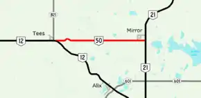
Alberta Provincial Highway No. 50 is a 14.5 km (9.0 mi) east–west highway in central Alberta, Canada. It runs between the hamlets of Tees and Mirror, northeast of Red Deer.[1][2]
| ||||
|---|---|---|---|---|
 | ||||
| Route information | ||||
| Length | 14.46 km[1] (8.99 mi) | |||
| Major junctions | ||||
| West end | ||||
| East end | ||||
| Location | ||||
| Specialized and rural municipalities | Lacombe County | |||
| Highway system | ||||
Provincial highways in Alberta
| ||||

Major intersections
From west to east: The entire route is in Lacombe County.
| Location | km[2] | mi | Destinations | Notes | |
|---|---|---|---|---|---|
| Tees | 0.0 | 0.0 | Western terminus | ||
| Mirror | 14.4 | 8.9 | Eastern terminus | ||
| 1.000 mi = 1.609 km; 1.000 km = 0.621 mi | |||||
References
- "2015 Provincial Highway 1-216 Progress Chart" (PDF). Alberta Transportation. March 2015. Archived (PDF) from the original on April 10, 2016. Retrieved October 12, 2016.
- Google (December 21, 2016). "Highway 50 in central Alberta" (Map). Google Maps. Google. Retrieved December 21, 2016.
This article is issued from Wikipedia. The text is licensed under Creative Commons - Attribution - Sharealike. Additional terms may apply for the media files.
