Alberta Highway 41
Alberta Provincial Highway No. 41, commonly referred to as Highway 41 and officially named Buffalo Trail, is a 686-kilometre (426 mi) north-south highway in eastern Alberta, Canada. It extends from the United States border at Wild Horse to Highway 55 in the hamlet of La Corey north of Bonnyville.[2]
| ||||
|---|---|---|---|---|
| Buffalo Trail | ||||
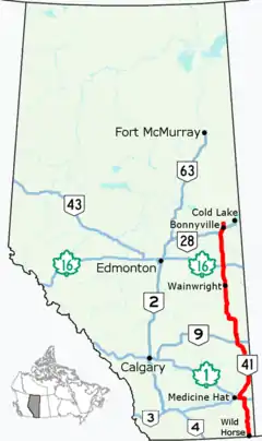 Highway 41 highlighted in red | ||||
| Route information | ||||
| Length | 689.1 km[1] (428.2 mi) | |||
| Major junctions | ||||
| South end | ||||
| ||||
| North end | ||||
| Location | ||||
| Specialized and rural municipalities | Cypress County, Special Area No. 2, Acadia No. 34 M.D., Special Area No. 3, Special Area No. 4, Provost No. 52 M.D., Wainwright No. 61 M.D., Vermilion River County, Two Hills No. 21 County, St. Paul No. 19 County, Bonnyville No. 87 M.D. | |||
| Towns | Oyen, Wainwright, Vermilion, Elk Point, Bonnyville | |||
| Villages | Consort, Czar | |||
| Highway system | ||||
Provincial highways in Alberta
| ||||

.svg.png.webp)
Major intersections
From south to north:
| Rural/specialized municipality | Location | km[1] | mi | Destinations | Notes |
|---|---|---|---|---|---|
| Cypress County | Wild Horse | 0.0 | 0.0 | Continues into Montana | |
| Canada–United States border at Wild Horse Border Crossing | |||||
| | 26.5 | 16.5 | |||
| Cypress Hills Interprovincial Park | 79.5 | 49.4 | PAR 115 west – Elkwater | ||
| 82.4 | 51.2 | ||||
| | 94.7 | 58.8 | |||
| 113.8 | 70.7 | Hwy 41 branches west; south end of Hwy 1 concurrency | |||
| Dunmore | 129.8 | 80.7 | Hwy 41 branches north; north end of Hwy 1 concurrency | ||
| | 136.8 | 85.0 | |||
| 168.2 | 104.5 | ||||
| 181.3 | 112.7 | UAR 168 west – Schuler | |||
| 192.9 | 119.9 | ||||
| 199.4 | 123.9 | UAR 154 west – Hilda | |||
| 218.8 | 136.0 | ||||
| ↑ / ↓ | | 229.2 | 142.4 | Crosses the South Saskatchewan River | |
| Special Area No. 2 | | 245.5 | 152.5 | ||
| 250.4 | 155.6 | UAR 139 north – Empress | |||
| ↑ / ↓ | | 254.3 | 158.0 | Crosses the Red Deer River | |
| M.D. of Acadia No. 34 | | 260.4 | 161.8 | ||
| 280.8 | 174.5 | UAR 178 east – Acadia Valley | |||
| ↑ / ↓ | | 290.9 | 180.8 | ||
| Special Area No. 3 | Oyen | 312.3 | 194.1 | ||
| | 315.6 | 196.1 | |||
| Special Area No. 4 | Monitor | 383.9 | 238.5 | Hwy 41 branches west; south end of Hwy 12 concurrency | |
| Consort | 401.2 | 249.3 | Hwy 41 branches north; north end of Hwy 12 concurrency | ||
| | 413.7 | 257.1 | PAR 121 east – Gooseberry Lake Provincial Park | ||
| ↑ / ↓ | | 429.3 | 266.8 | ||
| M.D. of Provost No. 52 | | 439.2 | 272.9 | ||
| Czar | 455.6 | 283.1 | UAR 220 west | ||
| | 459.8 | 285.7 | |||
| M.D. of Wainwright No. 61 | Wainwright | 499.3 | 310.3 | ||
| | 512.3 | 318.3 | |||
| 517.1 | 321.3 | Crosses the Battle River | |||
| 517.9 | 321.8 | ||||
| County of Vermilion River | | 536.2 | 333.2 | ||
| Vermilion | 556.4 | 345.7 | Interchange; Hwy 16 exit 577 | ||
| | 579.1 | 359.8 | |||
| County of Two Hills No. 21 | | 585.6 | 363.9 | South end of Hwy 45 concurrency | |
| 592.1 | 367.9 | North end of Hwy 45 concurrency | |||
| 602.1 | 374.1 | ||||
| County of St. Paul No. 19 | | 615.2 | 382.3 | Crosses the North Saskatchewan River | |
| Elk Point | 618.3 | 384.2 | |||
| | 627.6– 628.3 | 390.0– 390.4 | Y intersection; former Hwy 28 west | ||
| Kehewin No. 123 | | 644.1 | 400.2 | ||
| M.D. of Bonnyville No. 87 | Hoselaw | 652.0 | 405.1 | Hwy 41 branches east; south end of Hwy 28 concurrency; former Hwy 28A west | |
| | 662.3 | 411.5 | UAR 96 west – Bonnyville Beach | ||
| Bonnyville | 669.6 | 416.1 | Hwy 41 branches north; north end of Hwy 28 concurrency | ||
| | 672.8 | 418.1 | |||
| La Corey | 689.1 | 428.2 | |||
1.000 mi = 1.609 km; 1.000 km = 0.621 mi
| |||||
Highway 41A
| |
|---|---|
| Location | Cypress County, Medicine Hat |
| Length | 15.0 km (9.3 mi) |
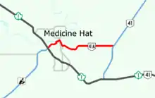
Alberta Provincial Highway No. 41A is the designation of an alternate route off Highway 41 serving the City of Medicine Hat. It branches off Highway 41 approximately 7 km (4.3 mi) north of the Trans-Canada Highway and runs approximately 12 km (7.5 mi). It winds through Medicine Hat and terminates at its junction with the Trans-Canada Highway and the Crowsnest Highway (Highway 3) west of the downtown core.
Major intersections
Starting from the east end of Highway 41A.
| Location | km[3] | mi | Destinations | Notes | |
|---|---|---|---|---|---|
| Cypress County | 0.0 | 0.0 | 50°01′48″N 110°32′01″W | ||
| Medicine Hat | 10.0 | 6.2 | Bridge Street SE | Hwy 41A branches west 50°02′00″N 110°39′24″W | |
| 10.6 | 6.6 | North Railway Street SE | Hwy 41A turns northwest 50°02′01″N 110°39′52″W | ||
| 11.0 | 6.8 | Prince Street SE | Hwy 41A branches northeast 50°02′12″N 110°40′03″W | ||
| 11.1 | 6.9 | Maple Avenue SE to | Hwy 41A branches northwest 50°02′14″N 110°39′59″W | ||
| 11.9 | 7.4 | 1 Street SE | Hwy 41A branches southwest 50°02′36″N 110°40′19″W | ||
| 12.1 | 7.5 | North Railway Street SE | Northeast-bound right-in/right-out 50°02′33″N 110°40′26″W | ||
| 12.2 | 7.6 | South Railway Street SE to | Northeast-bound right-in/right-out 50°02′32″N 110°40′30″W | ||
| 12.3 | 7.6 | 6 Avenue SE | 50°02′29″N 110°40′37″W | ||
| 12.6 | 7.8 | 4 Avenue SE | Hwy 41A branches southeast 50°02′24″N 110°40′53″W | ||
| 12.9 | 8.0 | 3 Street SE | Hwy 41A branches southwest 50°02′18″N 110°40′48″W | ||
| 13.4 | 8.3 | Division Avenue S | Hwy 41A turns west; becomes 3 Street SW 50°02′10″N 110°41′13″W | ||
| 14.0 | 8.7 | Gershaw Drive SW | Hwy 41A turns southwest 50°02′10″N 110°41′39″W | ||
| 15.0 | 9.3 | 50°01′45″N 110°42′11.8″W | |||
| 1.000 mi = 1.609 km; 1.000 km = 0.621 mi | |||||
References
- Google (January 22, 2018). "Highway 41 in Alberta" (Map). Google Maps. Google. Retrieved January 22, 2018.
- "2016 Provincial Highway 1-216 Progress Chart" (PDF). Alberta Transportation. March 2016. Archived (PDF) from the original on November 12, 2016. Retrieved November 12, 2016.
- "Highway 41A in Alberta". Google Maps. Google. Retrieved December 14, 2016.