Azilal Formation
The Azilal Formation, also known as Toundute Continental Series and Wazzant Formation, is a geological unit in the Azilal & Ouarzazate provinces of the High Atlas of Morocco, that cover the early Toarcian to early Aalenian stages of the Jurassic Period. It is a terrestrial deposit which overlies marine dolomites of equivalent age to the Budoš Limestone of Montenegro or the Marne di Monte Serrone of Italy.[8] Dinosaur remains, such the sauropod Tazoudasaurus and the basal ceratosaur Berberosaurus are known from the unit, along with several undescribed genera.[9] The Units inside the group have been considered individual on the past, being a division of the so-called "Couches rouges", and subdivided by a supposed geological scale.[10] The strata of the group extends towards the Central High Atlas, covering different anticlines, and topographic accidents along the range of the Mountains.[11] Although new studies have suggested that the strata is coeval in age, and should be referred to as a unique unit.[12][13] The Group is believed to have been a mostly deltaic, and river channels filled a succession of seashore and inland environments, covering the late Liassic coast of modern northern Africa.[14] Based on observed halokinetic strata, the Tazoult Ridge (that recovers part of the Tafraout Formation) evolved as a Salt Wall forming a 20 km long NE-SW trending structural and sedimentary high for at least 20 million years, between Pliensbachian-Bajocian periods. This emerged small landmass generated a great local diapir, with continuous Diapirism until the end of the Aalenian.[15][16]
| Azilal Formation Stratigraphic range: Early Toarcian-Early Aalenian 182–173 Ma | |
|---|---|
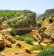
.jpg.webp) Panoramic of the High Atlas on Azilal | |
| Type | Geological formation |
| Sub-units |
|
| Underlies | |
| Overlies |
|
| Area | High Atlas[1][2][3] |
| Thickness | From a few meters to 800 m[2] |
| Lithology | |
| Primary | Mostly red Clay, sandstone, conglomerate |
| Other | Gypsum, Red marl[2] |
| Location | |
| Coordinates | 31.3°N 6.6°W |
| Approximate paleocoordinates | 26.6°N 3.4°W |
| Region | High Atlas[4][5][6] |
| Country | |
| Type section | |
| Named for | Azilal |
| Named by | Jenny et al.[2][7] |
| Location | Azilal |
| Year defined | 1985[1] |
| Thickness at type section | ~340 m (1,120 ft) |
 Azilal Formation (Morocco) | |
Main Azilal Strata
The Azilal Formation is the main sedimentary unit inside the Group. It was the first named unit, and one of the most studied since the 1980s.[2] It consists mostly on a succession of detritic rocks with Red Marls, deposited on an alluvial environment occasionally interrupted by shallow marine incursions, a Mudflat setting.[1][17] The lithology of the unit recovers also a Claystone-dominated interval, incised by metric dolomitized beds of Mudstones, Peloid-rich Packstones, Ooid-rich Grainstones, and Polymictic Conglomerates, all rich in Terrestrial plant debris (Mostly Ferns debris), with faunal content very poor and mostly dominated by microbial facies.[1][2] The Jbel El Abbadine zone provides the biggest afloration of the parts of a Calcareous massif, with strata of the Late Lias.[1] Mostly of this strata is recovered inside the Azilal Formation, with a succession of seashore and inland deposits.[1] Several seismic events located on the Tethian realm where the main genesis of the Tectonic activity locally, with emerged strata from the Paleozoic, that was eroded due to the local conditions.[18] Along with the Wazzant Formation, the two units and Azilal characterize the outer borders of the Atlas Gulf during the Toarcian-Aalenian. The Formations are a connected continuation, with the presence of abundant marine and Brackish common material, along with the fluvial facies of the Wazzant formation. On the disposition of the facies from north to south and from west to east, a lateral passage shows from coastal to fluvial sedimentary deposition, with foreshore facies and beach facies. The Azilal Formation was deposited on an environment more influenced by marine sedimentation than the Wazzant Formation.[1][17][19] Along the main Toarcian strata, there is a predominantly presence of basinal facies, dominant and quite uniform, leading to know a possible deposition controlled by thermal subsidence, generating a deposit of more than 5000 m of marls and calci-Turbidites accumulated until the end of Bajocian.[19] Part of the marine deposits of the Azilal Formation are a continuation of the common Lithiotid-Coral reef deposits from the Toarcian Central High Atlas.[20] Those reef-related facies start mostly on upper Pliensbachian-lower Toarcian boundary, and are commonly filled with Lithioperna, Cochlearites, and specially Phaceloidea corals that built reefal Framestones extended on lateral Biostromes.[20] The Azilal Formation coralline strata is nearly unexistent, compared with other formations of the High Atlas, showing a decreasing on these kinds of habitats as the Aalenian period started.[20] The aftermath of the Toarcian Oceanic Anoxic Event is also highly present on the marine strata of the formation, with the so-called Toksine Section, a succession of near shore marine strata disposed along the Toarcian boundary, where its last 40 m belong to the lower part of the Azilal Formation and are composed of dolomitized Mudstones and ooidal Grainstones, that show a slowly recovering a low-depth nearshore marine environment after in the Pliensbachian-Toarcian boundary a dramatic Tethys-wide collapse of the Neritic Carbonate System happened.[21] There is also a local record of a Cold Snap, where the Akenzoud section, that has 182 section meters on the Azilal Formation, and shows that after cold event that affect the local waters, related to the Karoo & the Atlantic Rift volcanism the present Brachiopods, based on their preserved oxygen isotope data show that warm seawater temperatures re-established during the early Late Toarcian.[22] The study of this section also revealed that the beach to nearshore deposits of the formation were part of a storm-dominated platform.[22] On the related strata there is a wide presence of storm events, as after the Toarcian AE and the rising of the temperatures on the late Toarcian the presence of ubiquitous storm deposits appear correlated to the warming of sea-surface temperatures, pointing to an intensification of tropical cyclones during the T-OAE and other warmer periods on the Toarcian.[23]
| Unit | Lithology | Thickness (metres) | Fossils |
|---|---|---|---|
| 1) | Sandstone with a wine tone, composed by grains that range from 1/4 to 1 mm | 0.2 m | Non present |
| 2) | Red Pelites: these levels form the horizontal table of the Summit | 4–5 m | Non present |
| 3) | Red Sandstone composed by grains of 1/2 mm in benches of 10 to 20 cm | 1 m | Non present |
| 4) | Lithified red Pelite | 2 m | Non present |
| 5) | Coarse red sandstone (pebbles of 1 cm with other pebbles, many less than 2 to 3 cm); a level with a clear escarpment, from 80 cm to 4 m on the southern flank of the hill and climbs a beautiful entertained estratification, sculpted by erosion | 0.8–4m | Non present |
| 6) | Sandy red pelites | 2 m | Non present |
| 7) | Red pelites passing through Leafy sandstone | 2 m | Non present |
| 8) | Sandy red pelites | 8–10 m | Non present |
| 9) | Yellowish marno-conglomeratic sandstone, with bones and remains of plants, which, when not transformed into Lignite, show traces of preserved structure; this lenticular layer, which does not seem to exceed 80 cm, locally contains regions of sandstone and Calcite Geodes | 0.8 m |
|
| 10) | Bluish sandstones of fairly variable composition: fine particles, with grains of 0.5 mm, thar contain various minerals such as Angular Quartz, Plagioclases, abundant Chlorite, clastic Andalusite and Iron Oxide; The coarse parts, the grain reaches 2 mm, consisting of often hexagonal Quartz and Moscovite, over Cemented Calcite; on the whole, there is an arched afloration of not only of a solid mass of Granite, locally of Granulite, but decorated with its metamorphic mass; Overall, this level has surface impregnations of Malachite | 2 m |
|
| 11) | Yellowish marno-conglomeratic Sandstone, like the level 9, also containing abundant bone material. | 0.7 m |
|
| 12) | Pelite and Bluish sandstones | 0.7 m |
|
| 13) | Very finely lit bistrated limestone, with green and purple grains | 0.2-0.3 m |
|
| 13) | Red, Bluish and Green Pelites, disposed on lenticular bands over yellow Breccia marls, parallel deposited with bodies od Calcite | 10–15 m |
|
Geology
The Central High Atlas of Morocco is part of a double‐vergent mountain belt that originated due to Cenozoic shortening and inversion of a rift that developed between the Triassic‐Jurassic periods.[24][1] The structure of the High Atlas can be defined by two main groups of faults, thrust and oblique‐slip faults, that occur from W‐E to NE‐SW.[24] The presence of different fault systems also suggests partitioning of deformation under a transpressive regime.[25] The presence of tectonic inversion in the Atlas Mountains has shown that are a intracontinental mountain belts that appeared from the uplift of pre-existing rift systems, where here is represented by a major rift system (~2000 km) originated on the Mesozoic, that was later uplifted and inverted in the Cenozoic.[24][25] The impact and convergence movements of the African-Iberian plates after the Mesozoic end with an inversion of the previous deposited strata, transporting the sediments of that and forming new low angle thrusts.[25] The High Atlas develops in a parallel way to the Paleozoic Anti‐Atlas belt, disposed across the south and rises up to 2.5 km.[25] The High Atlas and the Anti-Atlas are linked at the same time with the latter Miocene‐Pliocene Siroua Volcanic Field and the Saghro Massif volcanic field.[26] Related with the Cenozoic Volcanic fields, the Souss Basin appears at the west, oriented towards the Atlantic Ocean, and the Ouarzazate Basin. While across the southern basins the Precambrian and Paleozoic are directly overlain by Cretaceous strata, here Triassic sandstone and evaporite extends being covered by Lower to Middle Jurassic strata composed mostly by claystone.[27][28] Triassic, Jurassic and Cretaceous strata are confined within basins controlled by the extensional structures of the Mesozoic rift.[27] The Jurassic basins can be grouped into two main provinces located on either side of an emerged Massif Ancien: west, where the basin was open to the Early Atlantic, being related to its passive margin, and east with several epicontinental troughs connected to the Tethys Ocean.[29] Across the Toarcian-Bajocian strata, there was a great deposition of marine shales as marls, calciturbidites and reefal limestones, that where accumulated in the Central High Atlas, while on the west margin around the Massif Ancien terrestrial, specially fluvial sedimentation dominated.[29] The present Red Beds of Azilal indicate various marine transgressions across the Toarcian-Aalenian boundary, after ending its sedimentation on the Bathonian.[17][29] As that, Jurassic sediments are present of the central-southern basins, where they are up to 10 km thick carbonates, overlaid with minor Cretaceous and Paleogene deposits.[30][28] Jurassic strata is usually absent beyond the southern and northern parts of the Atlas ranges.[28] Along the Cretaceous strata this sediments had been exposed as part of an expansive body that we probably covered the entire Atlas domain, overlapping its margins, such as the Saharan Platform, the Anti‐Atlas and the Atlas Meseta, being part of a post-rift setting.[28] That would implicate a similar succession of the Jurassic basins in the American Atlantic margin, with a marked postrift unconformity close to the Jurassic-Cretaceous boundary.[29][28] Triassic and Jurassic synrift-related deposits are present especially on the external region of the Orogenic belt of the High Altas and nearly absent in the axial region, appearing in minor amounts within confined grabens.[31]
Rift Vulcanism
Along the High Atlas Triassic-Jurassic boundary, and until the Bathonian stage of the Middle jurassis, there is a record on vulcanism locally on the succession of different local formations, such as the own Azilal Formation and other, as the underlying Argane Formation.[32] Mostly of the north-african Rhaetian-Bathonian volcanic events are related to the open of the Atlantic Ocean, with parallel records found on the North American coast and other zones such as Mexico.[32] On some locations, such as Haute Moulouya, it is even possible to delimitate the transitions between the several Volcanic events that happened locally along the post Triassic-Jurassic boundary (Belonging to the Tizi-n-Ghachou Formation).[33] Mostly of the effects of the volcanism occur on the main emerged terrestrial deposits, where some of the nearshore strata was turned down du to tectonics, and hit after by volcanic eruptions of different grades, leading different kinds of volcanic strata.[19]
The origin of the Volcanism is related with the Geography of the zone. On the Hettangian-Sinemurian there was a post-rift carbonate platform developed in the Atlas area that emerged older marine strata. On the Middle Toarcian, subsiding basins appeared which isolated the Mesetas and Precambrian and Paleozoic massifs.[34] Alkaline magmas overflowed the created Central High Atlas basin.[35] This basins were fault-bounded basins, with variations of the sedimentary thicknesses and intra-formational breccias related to major blocks. The Magmatic Province of the Atlas influenced the deposition of the main strata, where the Terrestrial settings of some Formations (Including Azilal) was disposed over a series of cut extensional faults depicting a mosaic of horsts and grabens oriented to the East, North-East and East-West, with the Middle Atlas among the main areas of subsidence. The Central Atlantic Magmatic Province continue to erupt around the Pliensbachian–Toarcian event ∼183 Ma ago, overlapping the eruption of the Karoo–Ferrar igneous province. Middle-Late Toarcian Vulcanism was present but on smaller extension, as prove the Toundoute Continental Series Member.[36]
Tafraout Formation
The Tafraout Formation recovers a marginal marine to deltaic setting, with the presence of calcareous nodules, alternated along Marnes with bioclasts, and abundant ferruguinaceous material. The formation shows tides to the early Mesozoic Central Atlas rift, composed of Paleozoic rocks which provided the majority of the clasts present on the layers. A mostly marine margin recovers transgressions present on the Middle Toarcian on the basin, with accumulation of limestone with Lamellibranchians, that extends to the limit with the lowersmost Aalenian, along diverse sectors inside the Atlas Domain. The formation has an upper part with Lithiotid-dominated limestones, filled with the presence of corals, brachiopods and ooids.[37] Tafraout Formation sleeps over mostly Paleozoic strata, with granite and granodiorites, as well tectonic traces of Devonian volcanic activity.[38] In the Late Early Jurassic, the zone was part of a coastal Setting, with influence of fluvial facies at the north. Sinemurian deposition from older units was tectonically affected due to seismic activity on the Middle Toarcian, leading to a vertical stratification on some locations.[39][40] The so-called Aït Bou Guemmez Platform emerged on the Atlas Gulf around the Lower Toarcian, creating a small island ecosystem, that begin to deposit marine facies on the lower part of the formation, being one of the major tectonic accidents locally.[5] A series of sea transgressions recorded from the older Sinemurian to Aalenian strata show that various Island ecosystems appeared along the coast of the Goluf, implying changes on the sedimentation.[41] The warm climate of the Toarcian led to atmospheric changes, manifested on the Formation with depositions caused by tropical cyclone action, that decreased towards the late Toarcian Deposits.[23] The Trafraout Formation also recovers data from the post Toarcian Anoxic events on the Morocco Basin, with changes on the carbonate reserves on the lower layers, where hemipelagic marls suggest deposition after a change of the carbon cycle.[21]
Toundoute Continental Series
The Toundoute Continental Series lithology of the unit is divided into 5 units from D to H, (A-C represent the units of the underlying marine dolomite, with C representing a transition to terrestrial environment). The Toundoute sector recovers only the Middle to Late Toarcian, with an atypical paleogeographic element, located on the route of the South Atlas Accident, with several changes on the structure leading to show the instability of the deposit area. The formation shows the transition from carbonates to a series of continental detrital sediments, with palynomorphs and fossils.[42] Aalenian deposits recover the uppermost part near the Dadès valley, without any upper sediment present on the Main Toundoute Strata.[43] The presence of volcanic sedimentation is one of the most important aspects on the Toundoute strata.[42] The fragments can come from a reworking of Triassic basalt flows, with most of the products homogeneous, probably of trachyandesitic nature.[42] The deposits are young, probably related to the magmatism of the Middle Jurassic, with inflows probably contemporary with and related to eruptions, as in the case of many current volcanoes, in the form of dense flows. The tectonic processes on the high Atlas probably lead to most of the volcanic manifestations locally.[42]
Stratigraphy
The formation is subdivided on several stratigraphic levels, starting with the so-called facies of term A, composed by Gypsum and Salt, from Triassic age, supported by the presence of Volcanic Intercalations of basalt.[42][44][45][46][47] Above that, there are carbonates of term B alternated at the first with Dolomites, Pelites and Limestones along with Marly-Silt crimes with plant debris, which had regular influence of a marine environment.[42][46][47] That is proved by the presence of ooids, oncoliths, debris of molluscs and benthic foraminifers, being dissolved and recrystallized as sparite.[42][46][47] The third level shows a transition between marine and continental deposits, through carbonate palustrine levels and Caliche horizons, being continental layers superimposed in stratigraphic continuity over the marine carbonates of the lower Lias (Sinemurian-Hettangian).[42][46][47] Those continental layers are rich in Coarse Volcano-detrital episodes as result of a sedimentary process of high sedimentation rates, where the strata, including the deposit with Dinosaur fossils, where deposited on a short time interval, where Middle Jurassic Bajocian-Bathonian carbonate levels, frequent within the Atlas domain, do not exist not in Toundoute.[42][46][47] The sedimentation on the Toundoute member have some characteristics, such as lenticular channels with Sieve-Conglomerate of ~5 m thick (≤ 5m) for visible decametric, composed of several materials, like Volcanic products, as blocks of volcanic rocks such as sands made of Feldspars, black ferruginous grains from the surface of volcanic rocks on dry periods, siliceous green fragments from post-eruption processes (veins, microgeodes, nippled concretions), Limestone debris with traces of roots and cracks, where in some parts traces dark fine bushy algae filaments are still visible, similar to the genus Girvanella blue-green algae.[42][46][47] Other materials include schist and Vein Quartz, without bone and wood debris with a good cellular structure.[42][46][47] The Floodplain-like deposits are divided in two parts, with hard Limestone nodules, pink or brick and very irregular, typical of profiles of Calcimorph Soils formed on climates with pronounced dry phases. Those nodules had a visible reorganization in the channels, as a result of erosion of the alluvial plain by the fluvial network.[42][44] Finally there are present interlays of fine sandstone often laminated that mark the Flood facies from channels in period of flood, being composed only by plagioclase Feldspars and in a lesser proportion of orthoclases, along with small ferruginous grains or fine silts of quartz.[46][47] There is documentation of warm climatic conditions locally, that alternating wet and dry periods, as is seen on the other formations gave rise to soils with differentiated limestone profiles, such as Pedogenetic Nodules or Caliche.[42] The accumulation in the channels from calcimorphic soil profiles shows the presence of an active erosion on soils with probably sparse vegetation.[40][44][45]
| Unit | Lithology | Thickness (metres) | Dinosaur fossils |
|---|---|---|---|
| Alluvium | Holocene conglomerate | ||
| H | Clay-sandstone series | ≥ 100 | |
| G | Clay-sandstone series, with gypsum layer present at the top, just below this a second dinosaur bearing horizon is present with very similar lithology to unit F. | 50 | Tazoudasaurus, Berberosaurus[48] |
| F | Greenish grey clay-marl, detrital gravel to pebble-sized clasts with lignite and bones. | ≤ 5 | Present, indeterminate |
| E | Alternation of red-brown clay, fine sandstone and sandstone coarse conglomerates | 100 | |
| D | Clay, fine sandstone and conglomerate, large volcanic rocks present.[49] | 80 |
Wazzant Formation
The Wazzant Formation recovers a variation on the sedimentary process observed on the older Azmerai Formation. It is characterized by the presence of abundant Quartz sediments, along with the presence of red clay. Along the meridional border of the Guettioua Formation, on the same stratigraphic tendence is developed a red Sandstone-Pelitic deposition, that changes from Quartzo-Conglomerates to grains and fragments of Quartz, disposed with liassic calcareous strata.[50][51] is equivalent to the main Azilal "Marnes Chocolat".[50][51] The main sector occurs near Acfarcid, with an exposure of ~800 m, recovering the most detritic sector. Along this expossure, the Wazzant member appears at the right lateral, along massive calcareous dolomites, over the latest Pliensbachian strata, where the lower Toarcian strata is missing.[50] The Wazzant facies never exceed 50 m, getting its maximum exposure at the north of the Guettioua Formation.[50] The facies of the formation follow a deposition typical of Alluvial Plains.[2][17] It also recovers a succession of reddish brown tones predominantly terrigenous: Conglomerates, sandstone, clays related to paleosoils, along with dolomitized limestone. The Wazzant formation has a notorious proximal character compared to the Azilal formation. These deposits fill in many small tear pools in the Atlas Central.[52] Only its the stratigraphic framing allows to locate the formation in the Toarcian interval. The predominantly terrigenous deposits of this formation suggest they were deposited in continental setting, influenced by at least 6 different river channels, that trace its path to the Atlas Gulf. On the Toarcian-Aalenian transgression, the High Atlas domain experienced a long process of extension and rifting, recorded by the presence of marine carbonates and shales, found on the Wazzant Formation Beds. It is related to the formation of the Atlantic Rifting to the west and of the formation of the Tethys Ocean to the north.[53] The fluvial system of the Wazzant formation was led by a bigger river, and several minor freshwater currents, that where probably temporal and linked to rain seasons.[54] The presence of many dwarf lamellibranchs in the south of Azilal, the fine oblique stratifications, the floating plants and imprints of raindrops demonstrate that these two formations are of Aquatic origin, may be lagoonal, with temporary emersions.[50] Several fish fossils have also been found.[51]
Plantae
Paleobotany of the zone has shown that the layers at the Toundoute Continental Series there is not any major wood or plant macrofossil, although there is abundant infra-centimeter plant debris dispersed in the sediments.[42] This debris is composed mostly probably Leaflets of Ferns, and also on lesser quantities, Cycadophytas, most of them with preserved epidermis.[44] Palynological analysis did not deliver any palynomorph, but the Plant debris left some Tracheids.[44] On the debris, however, it was possible to isolate many wood debris, that was revealed to had characters such as Homoxylated structure apparently devoid of Parenchymas, with uniform rays, tracheids with uniseriate punctuation of the genus Abies (Abietoideae, on some aspects very similar to the species Abies koreana) and finally apex pikeoid type Oculipores vertically oriented, aspects typical from Coniferales, like Abietoideae, Pinaceae or Taxaceae.[42]
Color key
|
Notes Uncertain or tentative taxa are in small text; |
Algae
| Genus | Species | Stratigraphic position | Material | Notes | Images |
|---|---|---|---|---|---|
|
|
Cysts |
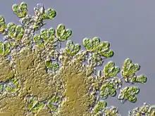
A Freshwater Green Algae of the family Botryococcaceae. On Issouka, the Toarcian layers have a substantial contribution of freshwater microplankton (sporomorphs and freshwater microplankton, such as Botryococcus). Younger strata shows an increase in marine palynomorphs, indicating a sea transgression happened afterwards. |
 Extant Specimens | |
Megaespores
| Genus | Species | Stratigraphic position | Material | Notes | Images |
|---|---|---|---|---|---|
|
Pollen |
Affinities with the Cheirolepidiaceae. The most abundant palynomorph on the layers. Can be a synonym with Classiopollis, although, has been left as its own genus on several occasions. Pollen from medium to large size Trees. |
|||
|
Pollen |
Affinities with the Cheirolepidiaceae. |
|||
|
Pollen |
Affinities with the Cupressaceae. |
|||
|
Pollen |
Affinities with the Cupressaceae. |
|||
|
|
Pollen |
Affinities with the Pinaceae. |
||
|
|
Pollen |
Affinities with the Araucariaceae. |
||
|
|
Spores |
Affinities with the Lycopsida. |
||
|
|
Spores |
Affinities with the Lycopsida. |
||
|
|
Spores |
Affinities with the Isoetales. |
||
|
|
Spores |
Affinities with the Selaginellaceae. |
||
|
|
Spores |
Affinities with the Selaginellaceae. |
||
|
|
Spores |
Affinities with the Pteridopsida. |
||
|
|
Spores |
Affinities with the Pteridopsida. |
||
|
|
Spores |
Affinities with the Pteridopsida. |
||
|
|
Pollen |
Affinities with the Gnetales. |
||
Invertebrates
Brachiopoda
| Genus | Species | Stratigraphic position | Material | Notes | Images |
|---|---|---|---|---|---|
|
Telothyris[60] |
|
|
Specimens |
A Lobothyrididae Brachiopod. Relatively abundant on seashore deposits. Includes juvenile forms of Telothyris jauberti, present on benthonic deposited strata. |
|
|
Homoeorhynchia[60] |
|
|
Specimens |
A rhynchonellidae Brachiopod. Relatively abundant on seashore deposits. Homoeorhynchia meridionalis juvenile forms are present. |
|
|
Stroudithyris[60] |
|
|
Specimens |
A Lissajousithyrididae Brachiopod. Mostly benthonic specimens are known. |
|
Ammonoidea
Nearly identical to the ammonites present on the North-East Morocco, Italy, North-west Europe, the Betic Cordillera of Southern Spain, and Portugal.[10][14]
| Genus | Species | Stratigraphic position | Material | Notes | Images |
|---|---|---|---|---|---|
|
H. sp. |
Specimens |
A hildoceratine ammonite. A single specimen is known, found in a benthic association, influenced by brackish waters.[60] |
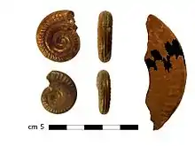 | ||
|
Protogrammoceras sp. juv |
Todrha-Dadès |
Specimens |
A hildoceratid ammonite. |
||
| Eodactylites[10][14] |
|
Todrha-Dadès |
Specimens |
A dactylioceratid ammonite. | |
Vertebrates
Fish
Several scales & teeth of unidentified fish are known from Mizaguène Hill and Acforcid quarry.[57]
| Genus | Species | Stratigraphic position | Material | Notes | Images |
|---|---|---|---|---|---|
| L. coryphaenoides |
Todrha-Dadès |
Various specimens |
A leptolepid bony fish. |
 | |
| L. semiserratus |
|
Various specimens |
A semionotiform bony fish. It has been found on freshwater lagoonal deposits with abundant plant debris.[57] |
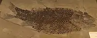 | |
| Indeterminate |
|
2 fragmentary specimens |
A coelacanthiform actinistian. It has been found on freshwater lagoonal deposits with abundant plant debris.[57] |
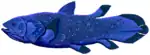 | |
Theropoda
Fooprints attributed to the ichnogenus Eubrontes have been found. They're suspected to be left between the Toarcian-Aalenian Boundary.[61]
| Genus | Species | Stratigraphic position | Material | Notes | Images |
|---|---|---|---|---|---|
|
Indeterminate |
Dorsal, sacral, caudal vertebrae, chevrons, 3 metatarsals, astragale, calcaneum, phalanges, femur and tibia. |
A coelophysid coelophysoid. According to Mickey Mortimer: "Assigned to Coelophysidae based on the apparent fusion between distal tarsal III and metatarsal III". It has been also proposed as a possible tetanuran.[65][66] That was dismissed by Benson in 2010.[67] Includes at least three different individuals that have been collected in Wazzant: two adults and a newly hatched juvenile. The former foot material resembles the Cretaceous Australian genus Kakuru, that has been proposed as a basal tyrannoraptoran. Mortimer said that "I really don't see much resemblance to Kakuru in the astragalus" and labeled it as a possible dilophosaurid or coelophysoid. Can be related to Notatesseraeraptor, although there isn't any overlapping material.[68] |
|||
|
Indeterminate |
|
Two teeth.[51] |
Labeled as "Theropoda Indet.", probably is a member of Neotheropoda, since basal theropods aren't known from the Jurassic. |
||
|
B. liassicus |
|
Neck vertebra, part of the sacrum, a metacarpal, a femur, and parts of a tibia and both fibulae. Part of another femur has been assigned to the genus as well.[45] |
Described originally as a basal representative of the Abelisauroidea, it was recovered as a basal ceratosaur in later studies.[69] It was a medium-sized theropod, measuring 5.1 m (17 ft) long, with a weight of 200 kg (440 lb). |
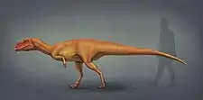 Berberosaurus life restoration and size comparison. | |
|
Indeterminate |
|
Described as a "Large theropod of uncertain affinities"[45] and as an "enigmatic theropod".[46] To quote Allain: "Two theropods have been found on Toundoute. The first theropod hasn't been described but shows a size larger than any of the know theropods of the Triassic-Early Jurassic know by now, indicating that Toarcian theropods had sizes rivaling that of late Jurassic allosaurs".[70] Aquesbi called it the "Grande Afrovenatorine".[63] |
|||
Sauropodomorpha
| Genus | Species | Stratigraphic position | Material | Notes | Images |
|---|---|---|---|---|---|
|
Indeterminate[63] |
|
Various phalanges.[51] |
Was mistaken as a theropod bone, but has similarities with Massospondylus and Lufengosaurus. If it is a massopod, it would be among the youngest ones found. |
||
|
T. naimi |
Partially articulated skeleton and cranial material including complete left mandible with teeth, quadrate, jugal, postorbital, parietal, frontal and exoccipital. Associated remains of a juvenile skeleton. |
A gravisaurian sauropod related to Vulcanodon. The most complete sauropod from the Lower Jurassic Found, with adult, sub adult and juvenile specimens.[45][46][47][48][63] |
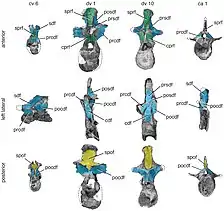 Representative vertebrae of Tazoudasaurus naimi. | ||
|
Indeterminate |
Tibia of 60 centimeters in length and 15-20 width, 5 dorsal & caudal vertebrae, fragmentary ribs, chevrons and several large badly determinable debris.[71][51][62] |
A eusauropodan sauropod with similarities with Volkheimeria and Klamelisaurus.[45][46][47][48][63] Was collected on a lagoonal depositional setting.[71] |
|||
|
Indeterminate[63] |
|
Various caudal vertebrae and several non studied pieces of large bones.[71] |
Probably related with Cetiosauridae or more parsimoniously Eusauropoda, having caudal vertebrae that resemble the ones from Cetiosaurus and Omeisaurus.[63] Was collected on a lagoonal depositional setting, with abundant plant debris. Termier (1942:203): "Despite the color of the grounds i do not think that these where deposited in a desertic region because the proportion of plants is really strong".[71] |
||
|
Indeterminate |
A possible basal Turiasaurid sauropod, that can be related to the recently described Narindasaurus or be a slightly more derived genus, judging by the similarity of the Humerous. It´s in the realm of possibility for it to be another advanced eusauropod. |
||||
See also
- Toarcian turnover
- Toarcian formations
- Marne di Monte Serrone, Italy
- Calcare di Sogno, Italy
- Sachrang Formation, Austria
- Saubach Formation, Austria
- Posidonia Shale, Lagerstätte in Germany
- Ciechocinek Formation, Germany and Poland
- Krempachy Marl Formation, Poland and Slovakia
- Lava Formation, Lithuania
- Whitby Mudstone, England
- Fernie Formation, Alberta and British Columbia
- Poker Chip Shale
- Whiteaves Formation, British Columbia
- Navajo Sandstone, Utah
- Los Molles Formation, Argentina
- Mawson Formation, Antarctica
- Kandreho Formation, Madagascar
- Kota Formation, India
- Cattamarra Coal Measures, Australia
References
- Jenny, J. (1985). Carte Géologique du Maroc au 1: 100.000, feuille Azilal. Notes et Mémoires du Ser vice Géologique du Maroc, 339.
- Le Marrec, A., & Jenny, J. (1980). L'accident de Demnat, comportement synsedimentaire et tectonique d'un decrochement transversal du Haut-Atlas central (Maroc). Bulletin de la Société Géologique de France, 7(3), 421-427.
- Jenny, J. (1988). Carte géologique du Maroc au 1/100 000: feuille Azilal (Haut Atlas central). Mémoire explicatif. Notes et mémoires du Service géologique.
- PALEOGEOGRAPHIQUES, C. E. R. (2002). LES FORMATIONS LITHOSTRATIGRAPHIQUES JURASSIQUES DU HAUT ATLAS CENTRAL (MAROC): CORRÉLATIONS ET RECONSTITUTIONS PALEOGEOGRAPHIQUES. Documents des laboratoires de géologie Lyon, (156), 163.
- El Bchari, F., Ibouh, H., Souhel, A., Taj-Eddine, K., Canérot, J., & Bouabdelli, M. (2001). Cadre stratigraphique et étapes de structuration de la plate-forme liasique d’Aït Bou Guemmez (Haut-Atlas central, Maroc). Gaia: Revista de Geociências, 16, 163-172.
- Laville, E., & Fedan, B. (1989). Le système atlasique marocain au Jurassique: évolution structurale et cadre géodynamique. Sciences Géologiques, bulletins et mémoires, 84(1), 3-28.
- Souhel, A., El Hariri, K., Chafiki, D., & Canerot, J. (1998). Stratigraphie sequentielle et evolution geodnamique du Lias (Sinemurien terminal-Toarcien moyen) de l'Atlas de Beni-Mellal (Haut Atlas central, Maroc). Bulletin de la Société géologique de France, 169(4), 527-536.
- Moragas Rodriguez, M. (2017). Multidisciplinary characterization of diapiric basins integrating field examples, numerical and analogue modelling: Central High Atlas Basin (Morocco) (Doctoral dissertation, Universitat de Barcelona).
- Haddoumi, H., Charrière, A., & Mojon, P. O. (2010). Stratigraphie et sédimentologie des «Couches rouges» continentales du Jurassique-Crétacé du Haut Atlas central (Maroc): implications paléogéographiques et géodynamiques. Geobios, 43(4), 433-451.
- Ettaki, M. & Chellaï, E. H. (2005). Le Toarcien inférieur du Haut-Atlas de Todrha-Dadès (Maroc) : sédimentologie et lithostratigraphie. C. R. Géosciences, Paris, 337: 814-823.
- Dresnay, R. D. (1971). Extension et développement des phénomènes récifaux jurassiques dans le domaine atlasique marocain, particulièrement au Lias moyen. Bulletin de la Société géologique de France, 7(1-2), 46-56.
- AMINE, F., BERRAHMA, M. H., & AARAB, A. (2014). Research Paper Inventory and Management of Dinosaurs Traces: A case Study of Azilal Region, Morocco.
- Ibouh, H. (2004). Du rift avorté au bassin sur décrochement, contrôles tectonique et sédimentaire pendant le Jurassique (Haut Atlas central, Maroc). These d’É tat. Université de Marrakech, Maroc.
- Ettaki, M., Ouahhabi, B., Dommergues, J. L., Meister, C., & Chellaï, E. H. (2011). Analyses biostratigraphiques dans le Lias de la bordure sud de la Téthys méditerranéenne: l’exemple de la frange méridionale du Haut-Atlas central (Maroc). Bulletin de la Société géologique de France, 182(6), 521-532.
- Martín‐Martín, J. D., Vergés, J., Saura, E., Moragas, M., Messager, G., Baqués, V., ... & Casciello, E. (2017). Diapiric growth within an Early Jurassic rift basin: The Tazoult salt wall (central High Atlas, Morocco). Tectonics, 36(1), 2-32.
- Ettaki, M., Chellaï, E. H., Milhi, A., Sadki, D. & Boudchiche, L. (2000a). Le passage Lias moyen-Lias supérieur dans la région de Todrha-Dadès: événements bio-sédimentaires et géodynamiques (Haut Atlas central, Maroc). C. R. Acad. Sci. Paris, 331: 667-674.
- Ibouh, H., El Bchari, F., Bouabdelli, M., Souhel, A., & Youbi, N. (2001). L'accident tizal-azourki haut atlas central du maroc: déformations synsedimentaires liasiques en extension et conséquences du serrage atlasique. Estudios Geologicos, 57(1-2), 15-30.
- Ettaki, M., Ibouh, H., & Chellaï, E. H. (2007). Événements tectono-sédimentaires au Lias-Dogger de la frange méridionale du Haut-Atlas central, Maroc. Estudios Geológicos, 63(2), 103-125.
- Dubar, G., & Mouterde, R. (1978).L'Aalenien et le Toarcien terminal du Haut Atlas; esquisse paleogeographique. Bulletin de la Société géologique de France, 7(2), 169-178.
- Brame, H. M. R., Martindale, R. C., Ettinger, N. P., Debeljak, I., Vasseur, R., Lathuilière, B., ... & Bodin, S. (2019). Stratigraphic distribution and paleoecological significance of Early Jurassic (Pliensbachian-Toarcian) lithiotid-coral reefal deposits from the Central High Atlas of Morocco. Palaeogeography, Palaeoclimatology, Palaeoecology, 514, 813-837.
- Bodin, S., Krencker, F. N., Kothe, T., Hoffmann, R., Mattioli, E., Heimhofer, U., & Kabiri, L. (2016). Perturbation of the carbon cycle during the late Pliensbachian–early Toarcian: New insight from high-resolution carbon isotope records in Morocco. Journal of African Earth Sciences, 116, 89-104.
- Krencker, F. N., Bodin, S., Hoffmann, R., Suan, G., Mattioli, E., Kabiri, L., ... & Immenhauser, A. (2014). The middle Toarcian cold snap: trigger of mass extinction and carbonate factory demise. Global and Planetary Change, 117, 64-78.
- Krencker, F. N., Bodin, S., Suan, G., Heimhofer, U., Kabiri, L., & Immenhauser, A. (2015). Toarcian extreme warmth led to tropical cyclone intensification. Earth and Planetary Science Letters, 425, 120-130.
- Beauchamp, W. (2004). Superposed folding resulting from inversion of a synrift accommodation zone, Atlas Mountains, Morocco.
- Lanari, R., Faccenna, C., Fellin, M. G., Abderrahim, E., Nahid, A., Medina, F., & Youbi, N. Tectonic evolution of the Western High Atlas of Morocco: oblique convergence, reactivation and transpression. Tectonics, e2019TC005563.
- Berrahma, M., Delaloye, M., Faure‐Muret, A., & Rachdi, H. E. N. (1993). Premières données géochronologiques sur le volcanisme alcalin du Jbel Saghro, Anti‐Atlas, Maroc. Journal of African Earth Sciences (and the Middle East), 17(3), 333–341.
- Scheele, J. (1994). Vom fruhmesozoischen Riftgraben zum intrakontinentalen Gebirge: Konvergente Blattverschiebungstektonik im zentralen Mittleren Atlas (Marokko) (Vol. 160). Selbstverlag Fachbereich Geowissenschaften, FU Berlin.
- Crasquin-Soleau, S., & Barrier, E. (Eds.). (1998). Epicratonic Basins of Peri-Tethyan Platforms (Vol. 179). Éditions du Muséum.
- Teixell, A., Arboleya, M. L., Julivert, M., & Charroud, M. (2003). Tectonic shortening and topography in the central High Atlas (Morocco). Tectonics, 22(5), n/a
- Arboleya, M. L., Teixell, A., Charroud, M., & Julivert, M. (2004). A structural transect through the High and Middle Atlas of Morocco. Journal of African Earth Sciences, 39(3–5), 319–327.
- Domènech, M., Teixell, A., Babault, J., & Arboleya, M. L. (2015). The inverted Triassic rift of the Marrakech High Atlas: A reappraisal of basin geometries and faulting histories. Tectonophysics, 663.
- Aït Chayeb, E. H., Youbi, N., El-Boukhari, A., Bouabdelli, M., & Amrhar, M. (1998). Le volcanisme permien et mésozoïque inférieur du bassin d'Argana (Haut-Atlas occidental, Maroc): un magmatisme intraplaque associé à l'ouverture de l'Atlantique central. Journal of African Earth Sciences, 26, 499-519.
- Ouarhache, D., Charriere, A., Chalot-Prat, F., & El-Wartiti, M. (2000). Sedimentation detritique continentale synchrone d'un volcanisme explosif dans le Trias terminal a infra-Lias du domaine atlasique (Haute Moulouya, Maroc)(Late Triassic to infra-Liassic continental detrital sedimentation synchronous with an explosive volcanic event in the Atlas area [Hgh Moulouya, Morocco]). Journal of African Earth Sciences, 31(3-4), 555-570.
- A Piqué, M Charroud, E Laville, L Aı̈t Brahim, M Amrhar The Tethys southern margin in Morocco and Cenozoic evolution of the Atlas domain. Peri-Tethys Memoir 5: new data on Peri-Tethys sedimentary basins Mémoire du Museum National d'Histoire Naturelle de Paris, France, 182 (2000), pp. 93-106
- Brahim, L. A., Chotin, P., Hinaj, S., Abdelouafi, A., El Adraoui, A., Nakcha, C., ... & Bouaza, A. (2002). Paleostress evolution in the Moroccan African margin from Triassic to Present. Tectonophysics, 357(1-4), 187-205.
- Cohen, A. S., & Coe, A. L. (2007). The impact of the Central Atlantic Magmatic Province on climate and on the Sr-and Os-isotope evolution of seawater. Palaeogeography, Palaeoclimatology, Palaeoecology, 244(1-4), 374-390.
- Ettaki, M., & Chellaï, E. H. (2005). Le Toarcien inférieur du Haut Atlas de Todrha–Dadès (Maroc): sédimentologie et lithostratigraphie. Comptes Rendus Geoscience, 337(9), 814-823.
- M’Barki, L., Abioui, M., & Benssaou, M. (2017). Géomorphosite marocain: Le paysage granitique de Tafraout au Maroc, des géomorphosites emblématiques. Dynamiques environnementales. Journal international de géosciences et de l’environnement, (39-40), 333-336.
- Ettaki, M., Sadki, D., Chellaï, E. H., & Milhi, A. (2008). Interaction eustatisme-tectonique dans le contrôle de la sédimentation au Jurassique inférieur et moyen dans la région de Todrha-Dadès (versant sud du Haut-Atlas central, Maroc). Notes Mémoires Serv. Géol. Maroc, 527, 55-64.
- Ettaki, M., Chellaï, E. H., Milhi, A., Sadki, D., & Boudchiche, L. (2000). Le passage Lias moyen–Lias supérieur dans la région de Todrha-Dadès: événements bio-sédimentaires et géodynamiques (Haut Atlas central, Maroc). Comptes Rendus de l'Académie des Sciences-Series IIA-Earth and Planetary Science, 331(10), 667-674.
- El Bchari, F., & Souhel, A. (2008). Stratigraphie séquentielle et évolution géodynamique du Jurassique (Sinémurien terminal-Aalénien) d’Ait Bou Guemmez (Haut Atlas central, Maroc). Estudios Geológicos, 64(2), 151-160.Ettaki, M., Ibouh, H., & Chellaï, E. H. (2007). Événements tectono-sédimentaires au Lias-Dogger de la frange méridionale du Haut-Atlas central, Maroc. Estudios Geológicos, 63(2), 103-125.
- Montenat, C., Monbaron, M., Allain, R., Aquesbi, N., Dejax, J., Hernandez, J., ... & Taquet, P. (2005). Stratigraphie et paléoenvironnement des dépôts volcano-détritiques à dinosauriens du Jurassique inférieur de Toundoute (Province de Ouarzazate, Haut-Atlas–Maroc). Eclogae Geologicae Helvetiae, 98(2), 261-270.
- Benvenuti, M., Moratti, G., & Algouti, A. (2017). Stratigraphic and structural revision of the Upper Mesozoic succession of the Dadès valley, eastern Ouarzazate Basin (Morocco). Journal of African Earth Sciences, 135, 54-71.
- Allain, Ronan; Najat Aquesbi; Jean Dejax; Christian Meyer; Michel Monbaron; Christian Montenat; Philippe Richir; Mohammed Rochdy; Dale Russell; Philippe Taquet (2004). "A basal sauropod dinosaur from the Early Jurassic of Morocco" (PDF). Comptes Rendus Palevol. 3 (3): 199–208. doi:10.1016/j.crpv.2004.03.001. ISSN 1631-0683.
- Allain, R., Tykoski, R., Aquesbi, N., Jalil, N. E., Monbaron, M., Russell, D., & Taquet, P. (2007). An abelisauroid (Dinosauria: Theropoda) from the Early Jurassic of the High Atlas Mountains, Morocco, and the radiation of ceratosaurs. Journal of Vertebrate Paleontology, 27(3), 610-624.
- Allain, R., & Aquesbi, N. (2008). Anatomy and phylogenetic relationships of Tazoudasaurus naimi (Dinosauria, Sauropoda) from the late Early Jurassic of Morocco. Geodiversitas, 30(2), 345-424.
- Peyer, K., & Allain, R. (2010). A reconstruction of Tazoudasaurus naimi (Dinosauria, Sauropoda) from the late Early Jurassic of Morocco. Historical Biology, 22(1-3), 134-141.
- Taquet, P. (2010). The dinosaurs of Maghreb: the history of their discovery. Historical Biology, 22(1-3), 88-99.
- Ellero, A., Ottria, G., Malusà, M. G., & Ouanaimi, H. (2012). Structural geological analysis of the High Atlas (Morocco): evidences of a transpressional fold-thrust belt. Tectonics-Recent Advances.
- J. Jenny, C. Jenny-Deshusses, and A. Le Marrec, P. Taquet. 1980. Découverte d'ossements de Dinosauriens dans le Jurassique inférieur (Toarcien) du Haut Atlas central (Maroc) [Discovery of dinosaur bones in the Lower Jurassic (Toarcian) of the central High Atlas (Morocco)]. 290:839-842
- Taquet, P. (1985). Two new Jurassic specimens of coelurosaurs (Dinosauria). The beginning of birds. Eichstätt, Germany: Freunde des Jura Museums, 229-232.
- Laville, E. (1978). Incidence des jeux successifs d'un accident synsedimentaire sur les structures plicatives du versant nord du Haut Atlas central (Maroc). Bulletin de la Société géologique de France, 7(3), 329-337.
- El Harfi, A., Guiraud, M., & Lang, J. (2006). Deep-rooted “thick-skinned” model for the High Atlas Mountains (Morocco). Implications for the structural inheritance of the southern Tethys passive margin. Journal of Structural Geology, 28(11), 1958-1976.
- Stokes, M., & Mather, A. E. (2015). Controls on modern tributary-junction alluvial fan occurrence and morphology: High Atlas Mountains, Morocco. Geomorphology, 248, 344-362.
- Rodrigues, B., Mendonça Filho, J. G., Silva, R. L., Sadki, D., & Duarte, L. V. Palynofacies as indicator of paleoenvironmental dynamics across the Early Toarcian in Middle Atlas Basin (Morocco).2nd International Workshop on the Toarcian Oceanic Anoxic Event Abstract Book. Coimbra, September 6th – 9th, 2018. IGCP-655
- Courtinat, B., & David, B. (1984). Analyse multivariee de trois populations de Corollina du Jurassique marocain. Review of palaeobotany and palynology, 41(1-2), 39-50.
- Courtinat, B., & Le Marrec, A. (1986). Nouvelles données palynologiques sur les Couches rouges (Jurassique moyen) de la région de Demnat (Haut-Atlas, Maroc). Bulletin de l'Institut Scientifique (Rabat), (10), 15-20.
- Aadjour, M. (2004). Le mésozoïque des bassins d’Essaouira-Abda et Doukkala (Marge atlantique marocaine): Stratigraphie, palynologie, géochimie et évolution géodynamique.
- Bassoullet,J.-P. et al. (1991) Global stratigraphy in the Moroccan Toarcian (South-Rifan Ridge and Middle Atlas) [ Stratigraphie integree dans le Toarcien du Maroc (Rides Sud-Rifaines et Moyen Atlas) ] Bulletin de la Soci©t© G©ologique de France, 8e s©rie Vol. 162 # 5 P. 825- 839
- Ettaki, M., Ibouh, H., Chellaï, E.H., 2007. Événements tectonosédimentaires au Lias-Dogger de la frange méridionale du Haut-Atlas central, Maroc. Estudios Geológicos 63, 103-125.
- H. Plateau, G. Giboulet, and E. Roch. 1937. Sur la présence d’empreintes de Dinosauriens dans la région de Demnat (Maroc) [On the presence of dinosaur tracks in the Demnat region (Morocco)]. 7(16):241-242H.
- TAQUET, P. (1986). Les découvertes récentes de dinosaures au Maroc. In Les dinosaures de la Chine à la France. Colloque international de paléontologie (pp. 39-43).
- Aquesbi, N. (2008). Les sites de Dinosaures du Lias du Haut Atlas (Maroc): Problèmes de phylogénie et de paléogéogrphie.
- Taquet, P. (1999). Dinosaur impressions: postcards from a paleontologist. Cambridge University Press.
- Allain, Ronan & Bailleul, Alida (2010):FIRST REVISION OF THE THEROPOD FROM THE TOARCIAN OF WAZZANT (HIGH ATLAS MOUNTAINS, MOROCCO): THE OLDEST KNOWN TETANURAE?. Abstracts du 1er Congrès International sur la Paléontologie des Vertébrés du Nord de l’Afrique.
- Allain, R. 2002. Discovery of a megalosaur (Dinosauria, Theropoda) in the middle Bathonian of Normandy (France) and its implications for the phylogeny of basal Tetanurae. Journal of Vertebrate Paleontology, 22: 548–563.
- Benson, R. B. (2010). The osteology of Magnosaurus nethercombensis (Dinosauria, Theropoda) from the Bajocian (Middle Jurassic) of the United Kingdom and a re-examination of the oldest records of tetanurans. Journal of Systematic Palaeontology, 8(1), 131-146.
- http://dml.cmnh.org/2002Feb/msg00624.html
- Dal Sasso, C., Maganuco, S., & Cau, A. (2018). The oldest ceratosaurian (Dinosauria: Theropoda), from the Lower Jurassic of Italy, sheds light on the evolution of the three-fingered hand of birds. PeerJ, 6, e5976.
- Allain, R. (2012). Histoire des dinosaures. Perrin.
- Termier. 1942. Données nouvelles sur le Jurassique rouge à Dinosauriens du Grand et du Moyen-Atlas (Maroc) [New data on the Jurassic red beds with dinosaurs from the Great and Middle Atlas (Morocco)]. 12(4-6):199-207