Ciechocinek Formation
The Ciechocinek Formation, formerly known in Germany as the Green Series (German: Grüne Serie) is a Jurassic (lower Toarcian) geologic formation that extends across the Baltic coast, from Grimmen, Germany, to Nida, Lithuania, with its major sequence on Poland and a few boreholes on Kaliningrad.[4] Dinosaur remains are among the fossils that have been recovered from the formation, including the Thyreoporan Emausaurus and others which have not yet been allocated to a specific genus. The layers assigned to the formation are a group of sediments that differ from the those of the Posidonia Shale and other Toarcian formations of Europe.[5] Most of the sediments of the Polish realm come from deltaic, fluvial and marine deposits.[6] In the Polish realm there is also an abundance of siderite, attributed to mixed saline and marine action, with the rounding off of some due to transport by freshwater or sea currents.[7] Its main equivalents are the Posidonia Shale, upper part of the Rydeback Member, Rya Formation (Southern Sweden), the Fjerritslev Formation (Danish Basin), the Bagå Formation (Bornholm) or the Lava Formation (Lithuania).[2] There are also coeval abandoned informal units in Poland: Gryfice Beds (Pomerania region), Lower Łysiec beds (Częstochowa region), or the "Estheria series".[2]
| Ciechocinek Formation Stratigraphic range: Early Toarcian ~181–178 Ma | |
|---|---|
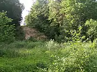
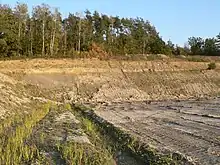 Kozłowice Cement Quarry Outcrop, the main of the Formation | |
| Type | Geological formation |
| Unit of | Kamienna Group |
| Sub-units |
|
| Underlies |
|
| Overlies |
|
| Area | Polish Basin-North German Basin |
| Thickness | 125–500 m (410–1,640 ft) |
| Lithology | |
| Primary | Claystone & abundant Clay Pits[2] |
| Other | Sandy-clayey sediments deposited with traces of breaks and weathering. Grey heteroliths, Mudstones, Claystones, Siltstones and fine-grained Sandstones[2] |
| Location | |
| Country | |
| Extent | 20,000 km2 (7,700 sq mi) |
| Type section | |
| Named for | Ciechocinek, Poland |
| Named by | Stefan Zbigniew Różycki (as an informal unit)[2][3] |
| Year defined | 1958 |
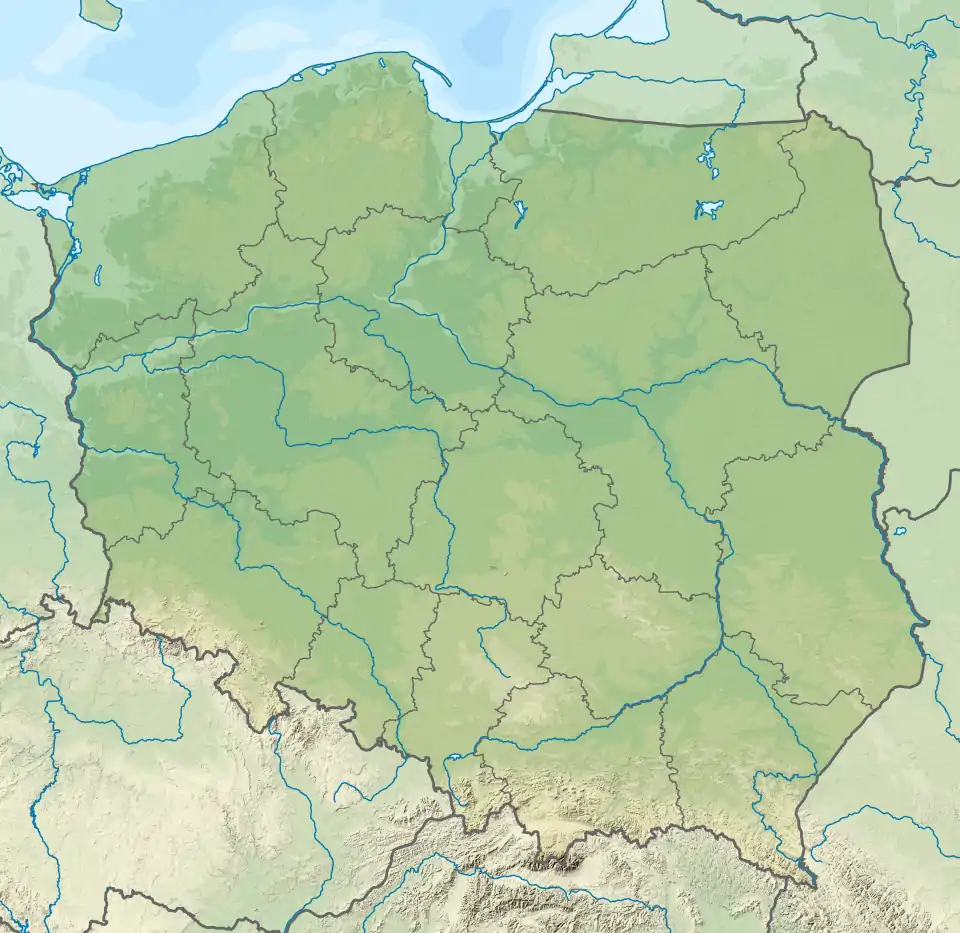 Ciechocinek Formation (Poland) | |
"Green Series"
History
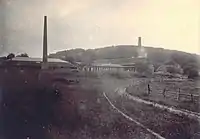
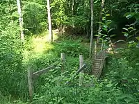
The Green Series (German: Grüne Serie) comes from a series of lower Jurassic sediments found in 1873. The first described deposit consists on several Grey, Plastic Clay from a 300 m railway cutting near the village of Schönenwalde, at 4 kilometres (2.5 mi) at the north of Grimmen.[8][9] Using the ammonites as a reference, it was established in 1909 that the Grimmen Pits were the regional equivalent of the mostly southern Germany Posidonia Shale. Also, some of the sediments were vinculated with finds of the Toarcian of Bornholm.[10] During the 1950-60 there was recorded a wider distribution of the Grimmen Clay sediments on the surrounding areas, which led to the opening of a Klay Pit near Klein Lehmhagen in between 1959 and 1961.[8] Since that year the extension of the former pit has grown, giving detailed insights into the sedimentology.[11] The liassic strata shows a clear Glacial Deformation, with several layers being deposited as a result of last Glacial period erratics.[8] The mined Clay of Klein Lehmhagen was used as an addictive for concrete production.[12] It was closed in 1995, and has filled with freshwater since 2002.[8] Later, the Green Series was established as part of the Ciechocinek Formation, and referred to as such in later works.[13] Other of the related strata are the clay pits along Dobbertin, with the most famous being the Schwinzer Hellberg clay pit.[14] The Toarcian sediments & occurrences in the Schwinzer-Hellberg appear on the northeastern slope of Hellberg, and was first found and excavated out in 1879 by the Rostock geologist Eugen Geinitz, being recognized as such.[15][16] After that, Geinitz did various research on the Pit,[17] with studies about the fauna and fossil content, mostly on the Ammonite fauna.[18] He compared it to the Posidonia Shale that he had studied at the same, and estimated a Toarcian age for the Pit, based mostly on the Ammonite taxa.[19] Other studies pointed out that the strata of the Pit contained also Pliensbachian taxa, with incorrectly classified Ammonites, mostly of Lower to Middle Toarcian, with others from the Latest Pliensbachian.[10] It was Oertel on several studies who divided the strata delimitating it to the late liassic (Pliensbachian-Toarcian) based on the Ammonite Fauna.[14] The former clay pit has been under protection as a geological natural monument since 1991, as the exposed layers are considered an exceptional land–sea facies distribution during the Toarcian and also its international fame, due to its wealth of fossils from the northern margin of Fennoscandia.[14]
Lithology
The lithology of the Pits consists mostly on Gray-yellow and red-brown Clay Marl follow over Pyrite and Gypsum-bearing clay stones of the upper part of the formation strata, that have abundant "Marl" concretions, called "Amaltheentone". The strata is filled with mostly marine fauna, Belemnites, Bivalves, Gastropods, whose hard parts become lithified and part of the deposited grains. There is Silty to fine Sand and weakly carbonatic, Mica-bearing Posidonia Shale facies at the southernmost point.[20] Along with that, there is abundance of layered blue-gray, lime-free Clays of the "Green Series" with lime concretions that contain a rich fauna, such as Ammonites, Bivalves, Insects,[21][22] Crabs and fishes of several orders, all from the Toarcian, since the Pliensbachian strata is not part of the Green Series.[23] Other pits, like the Grambow well, at 9 km distance from the Dobbertin pit, shows stratification on a 70–120 m thick succession, that is composed by an almost monotonous dome with changing Clay, Silt and fine Sand fractions, while in western and central Mecklenburg closes with a blue-gray, locally also greenish, brown-banded Claystone horizon.[23] It follows more at the south the Toarcian black-brown to dark gray-colored, Posidonia shale.[23] The "Green Series" is presented locally with bold clays that begin in Altmark and W-Mecklenburg with an extension to the east of over 100 m thick. There is also a high content and proportion of unstable heavy minerals in the Toarcian clays, that indicate basaltic volcanism sediments, translated probably from nearest inland strata.[24] The local Vulcanism started on the lower Pliensbachian, and extends along the North Sea and mostly from southern Sweden.[25] At this time, the Central Skåne Volcanic Province and the Egersund Basin expulsed most of his strata, with influences on the local tectonics.[25] The Egersund Basin has abundant fresh prophyritic Nephelinite lavas and dykes of lower Jurassic Age, with a composition nearly equal to those found on the clay pits. That reveals the translation of strata from the Continental margin by large fluvial channels, that ended on the sea deposits of the Ciechocinek Formation Green series.[25]
Stratigraphy
The Dobbertin & Grimmen Clay Pits are the main ones, where the Liassic rocks are known only from deposits in the Pleistocene regional modifications.[26] Reflection by seismic measurements show that the upper edge of the Mesozoic layers is at a depth of approximately at 500 m.[23] These are highly deformed sediments of the lower Toarcian, that in contrast to the typical Posidonia Shale in Central and Western Europe, is filled by plastic Clay facies, that get the name of "Green Series". This clay is considered in part as the weathering product of an early Jurassic Alkaline-Basalt volcanism that developed in Skåne,[27] that was transported from the Fennoscandian continental mainland more than 100 km away on the sea through large rivers to the adjacent epicontinental marginal area of the North German Basin.[20] The coastline of the main continental series was divided by Flat islands, Bays and Lagoons. Minor changes in salinity led to more brackish conditions, that result on a lack of abundant marine fauna, such as Echinoderms, Belemnites. There is a glacial deformation of the sediments, that showed thanks to the now low erosion conditions, preventing a detailed recording of the entire sequence, which depends essentially to be reconstructed by the fossil content of the concretions.[20] In the western part of the pit, open, fine-grained Quartz sands with traces of charred plant remains have been interpreted as interglacial moved strata of the formation or rearranged Tertiary material.[28] But it could also be higher areas of the "Green Series" and thus represent an important layer in the Toarcian sequence, implying a descent of the water levels through the Middle Toarcian.[20] Several other pits on the north German Basin, make possible to correlate this and other erratic deposits, using the stratigraphic sequence present, common to most of them.[23] On the Grimmen & Dobbertin Clay Pits, Tertiary coverage over the upper lias strata is already lost, while in Goldberg the strata thickness has decreased due do recent erosion.
| Unit | Age | Lithology | Thickness (metres) | Fossils |
|---|---|---|---|---|
|
Green Series Upper[29] |
Exaratum-Subzone |
Gray-green clays with carbonate concretions. The youngest sediments are made of light quartz sand silt and tapes. |
4–5 m |
Fish remains, bivalves, ostracodans, crustaceans and plants |
|
Green Series B[29] |
Elegantulum-Subzone |
|
2–6 m |
Fish remains, ammonites, belemnnites, icthyosaurs, plesiosaurs, crocodrylomorphs, dinosaurs, insects, bivalves, ostracodans, crustaceans and plants. Frequent occurrence of the ammonites of the species Eleganticeras elegantulum |
|
Posidonia Shale Invasive strata[29] |
Upper Tenuicostatum |
Black shales with abundant ammonoid material. |
3 m |
Fish remains, ammonites, belemnnites, bivalves, ostracodans and crustaceans. The ammonite Dactylioceras is abundant in this layer. |
|
Green Series C[29] |
Lower-Medium Tenuicostatum |
Fine sand with carbonate lenses. A few meters of powerful, dark brown, plastic tones, which occasionally form head-sized, loaf-shaped that contain stratified carbonate concretions with rich fossil guidance. |
4–7 m |
Fish Remains, ammonites, belemnnites, echinoderms, annelidans, anthozoa, icthyosaurs, plesiosaurs, crocodrylomorphs, dinosaurs, insects, bivalves, ostracodans, crustaceans and plants. |
|
Green Series "Basic Toarcian"[29] |
Base Tenuicostatum |
Coarse quartz sand |
1–2 m |
Fish remains, ammonites, belemnnites, icthyosaurs, insects, bivalves, ostracodans, crustaceans and plants. |
|
Uppermost Pliensbachian strata (Domerian)[29] |
Domerian Realm |
Fine sand silt sequence with pyrite concretion |
6 m |
Fish remains, ammonites, belemnnites, echinoderms, bivalves, ostracodans, crustaceans and plants. |
"Ciechocinek Series"
History
Several works were done in the 1920s on the Jurassic sediments of Poland, where the main stages, specially Lias and Dogger where stablished. At the same time, facies along the Town of Ciechocinek were classified as possible Lias-Dogger transition, without anything more clear after this.[30] In 1954 a first drill process was done in Ciechocinek, where the geology of the zone was related to Jurassic sedimentation, although a concrete datation beyond lias was not possible.[31] That first drilled borehole would become latter the main pit of the Formation. It wasn't until 1958, when the eminent Geologist Stefan Zbigniew Różycki proposed the name Ciechocinek Series, that was left temporally as an informal unit.[3] Różycki was the first to study in-depth the strata recovering the formation, that he called "Seria Ciechocińska" (Ciechocinek Series), and report a structure based on clay rocks, represented by mudstones, claystones, and shales with the find of clays with quite a high kaolin content. It also does the first comparation with the slightly younger Seria borucicka (Borurice Beds), and estimate that the rocks were approximately of Late Liassic in age, with the possibility of finding Dogger Sediments on the uppermost parts.[3] Also, suggests that they were analogue to the Ostrowiec series of Świętokrzyskie Mountains.[3] Later works use the name Ciechocinek Series, doing studies about sedimentology on the layers already Drilled, or founding new Boreholes with similar composition of Kaolinite and related materials.[32] Was in the 1960s, when the name "Formazaja Ciechocińska" was first suggested, at the same time the stratigraphy of the formation led to exclude Middle Jurassic Strata, being linked now in first instance to the Posidonia Shale of Germany.[33] The first Polinic studies where done.[34] And in 1966, the name was already established. At this time, the Kaolinitic content was related to a depositional setting based on a large deltaic succession, and compared to large modern rivers, suggesting a tropical climate for the formation.[35] The First Floral analysis came from the comparison with the Borurice Formation in 1973, finding pollen of Lycophyta and others assigned to Isoëtaceae.[36] In the late 1970s was recovered as the Toarcian succession of the Polish Basin, linked in age to the Posidonia Shale and to the deposits of Dobbertin and Grimmen of the same age.[37] A major floral analysis was done in 1980, where Rogalska described an ample variety of flora based on microparts of leaves and pollen, but using modern genera to describe its finds, such as Cedrus.[38] Several works were done related to tectonic changes that affected the sediments in 1988, relating for the first time the formation with possible regional vulcanism.[39] In the 2000s the greatest part of the work on the Formation was done, studying its geology, stratigraphy and sedimentation.[6][7] And in the 2010s was related to the Northern German Deposits, that were confirmed as part of the formation in various studies in 2017[40] and 2018.[4]
Lithology
The Ciechocinek is composed mostly by muds and silts, along with poorly consolidated Mudstones and Siltstones with lenses and subordinate intercalations of fine-grained sandy lenses, typically from 1 mm to less 20 cm thick, extended a few meters, along also with sandstones. Diagenetic Siderite intercalations and concretions, ~20 cm thick, as well as Pyrite concretions are also present.[6] The mineralization of siderite occurs in all types of Ciechocinek Formation deposits. Include fine crystalline variety, coarse crystalline rhombohedra and fine crystalline aggregates impregnated by a mixture of undetermined Fehydroxides.[7] The mineralization of the siderites on certain layers is associated to the abundance of organic matter, with the decay of it ending on a progressive carbonate supersaturation, with an early precipitation on the nucleus of the siderites. They reflect also the conditions of salinity on the water, showing alternances in short periods, associated with the abundance of organic matter.[7] Siderite Spherulites have also been recorded on heaps near Kuraszków and also single spherulites or groups of several appear in the Brody-Lubienia borehole among the light gray Mudstone.[41] Muds and mudstones consist mainly of particles with the size of common clay, some with an admixture of silt; sandy muds and mudstones are also encountered in counterpart to the pure clays and claystones, without admixtures of other fractions, that are rare or extremely rare. Mudstones are poorly consolidated, tren to disintegration, swell and become plastic, being the only exceptional ones those the heavy sideritic mudstones, that range from a wide variety of colors, from brown or cherry-red in colour, with an olive shade often appearing.[6] On the other hand, there are abundant poorly consolidated Quartz sandstones, that are regularly intercalated with Silt and Siltstone.[6] Along the Sandstones, there are Chlorite and Kaolinite grains. Plant microremains are common, concentrated with mica flakes on lamination planes, while larger wood fragments, several cm long, are also moderately frequent.[6] Heavy minerals are present and include as the most common Euhedral forms such as Zircon, Rutile and Tourmaline, along with angular fragments of Rutile, Garnet and Staurolite, with finally well-rounded oval grains of Zircon, Rutile, Garnet and Tourmaline. Outside the main heavy minerals, it is possible to find well-rounded grains of green Hornblende, Apatite, Disthene, Epidote, and finally on one study one Pyroxene grain was found.[6] The presence of Kaolinite, related to continental formation in tropical climate environments for the chemical weathering of different igneous, metamorphic and sedimentary rocks, along with Chlorite & Biotite, suggest a deposition linked to fluvial & deltaic forces. The eastern Sudetes and their foreland are the best candidates to be the origin of the transported material, as they have a nearly identical composition, being the Lower Jurassic deposits in the Fore-Sudetic Monocline linked Cracow-Czêstochowa Monocline, with the strata of the Formation.[6]
Stratigraphy
Deposits of the Ciechocinek Formation are related to a brackish-marine origin, being deposited in an epicontinental sedimentary basin on Poland, that was the eastern arm of the Mid-European Toarcian Basin.[6] Sedimentological analyses pointed to a deposition in a shallow basin, prevalently at <20 m deep, with present features of a large, shallow, brackish embayment.[42] The Structure of the main depositional setting has been seen divided in 3 parts: on the center, near Kaszewy Kościelne there was a major restricted brackish-marine basin, with seasonal influxes of marine water.[42] Around it, a series of restricted brackish-marine embayments where developed, leading to a transitional environment, formed by Lagoons, Dune Barriers, Delta Fronts, Delta Plains and Marshes, influenced by brackish-marine water.[42] All of this was influenced by deltaic facies, that has its origin on marginal parts. Well preserved estructural successions along the strata show that the depositional environment of the formation was strongly influenced by storm periods.[43] During that storm periods, paleocurrents transported sand and other components from nearshore to distal settings, being after that reworked by waves and distributed along the sea floor, by several wave related flows.[43] Distal settings show the influence of the storms with due to the presence of several laminated deposition of sand-silt streaks, cross-laminated Silt, small Sand lenses and interlaid Mud-Silt-Sand Heteroliths.[43] Near Settings are represented on the strata by several centimetre thick layers and sand packets, with several traces and sedimentary structures, such as wave parallel and crossbed ripplemarks. Along this strata, trace fossils are deposited on settings where geochemical analises show the presence of a brackish water influence on the basin.[43] The main component of the deposits are muds, intercalate sandstones & silts disposed on a high variety of structures, with at least twelve lithofacies that run from fine-grained sedimentations to wave-dominated sandy shoals. It is believed that the dominant sedimentation was by quiet mud and silt sedimentation from suspension, which probably come from near River Mouths. It was a sedimentary basin with a continuous influx of Clay and fine Silt, to which sand was brought by events such as river transportation, storms, eustatic effects, and other related.[44] There is a detailed succession of changes in the strata with time, where the location of the river mouths shifted because of effects such as the progradation of deltas, the stop of the flux of river channels and the long-lasting eustatic sea-level changes, all of that can be confirmed by the presence of microstructures as result of erosion and cross lamination in the mud-silt facies.[44] A Marine transgression correlated to the rise of the sea level on the Lower Toarcian is clearly visible on the Silesian-Cracow area, where the sea encroached the Polish Trough, which resulted in the end of the Pliensbachian alluvial sedimentation, that can be observed on the underlying Blanowice Formation. The presence of alluvial sedimentation still on the nearshore environments, as an effect probably related to floods.[44] On some layers it was observed that the chemistry of the sea water was changing as the deposition continues on the most recent layers of the Ciechocinek Formation, implying the possible formation of a brackish environment, probably due to the sedimentation of fluvial currents. Most of the invertebrate traces reported from the formation, come from these layers.[44] It contains several marine dinoflagellate cysts, Foraminiferal linings and a relatively di verse trace fossil, such as Planolites, Palaeophycus, Helminthopsis, Gyrochorte, Protovirgularia, Spongeliomorpha and Diplocraterion associated with pyrite mineralization.[44][43] On the upper levels of the formation there is a clear change in the sedimentation: a sea regression with a palatine alluvial progradation. The sea left seashore lakes, lagoons, deltas, Mangroves, with the emergence of the land confirmed by the occurrence of plant roots and desiccation cracks.[44] This is also shown on the changes on the fauna present, where the trace fossils get more abundant, specially Planolites and there is appearance of phyllopods of the genus Estheria, reflecting decline in water salinity.[43]
Profile
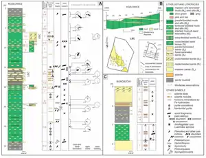
| Unit | Lithology | Thickness (metres) | Fossil Palynology/Flora | Fossil Fauna |
|---|---|---|---|---|
|
Youngest[45] |
Gray-green Clay and Silt, horizontal and lenticular lamination, vegetable chaff, at a depth of 0.6-1.6 m plant roots - levels of fossil soils |
767,4–773,4 m depth on the General Lithological Profile |
|
Non Reported |
|
N1[45] |
Gray, laminated Mud, at a depth of 0.3 m plant roots - fossil soil levels 3.5 m - very fine-grained, gray-green Sandstone, brown in some places, diagonal gutter layering, numerous plant roots in the upper part. The Core of this level is poorly preserved |
773,4–779,8 m depth |
|
|
|
N2[45] |
Undulating heterolite, dolomitic in the upper part (15 cm), with clay, gray-green Mudstone in some places, lenticular lamination and lenticular layering, two levels with plant roots. |
779.8–786.5 depth |
|
Non Reported |
|
N3[45] |
Very fine-grained, gray-yellow Sandstone, Mudstone, subordinate gray-green Clay, horizontal and lenticular lamination, layering lenticular, at a depth of 0.9 m, wavy, chaff. |
786.5–792.8 depth |
|
|
|
N4[45] |
3.5 m - green-gray, wavy and streaky Heterolith, lenticular in the lower part, with two inserts of Sandstones with erosive bases and dome diagonal layering (Tempestites). Followed by a level of horizontally, occasionally lenticular lamination. |
792.8–799.5 m depth |
|
|
|
N5[45] |
4.5 m of gray-green Clay, sometimes with a shade of brown (diffused Siderite), laminated horizontally, occasionally lenticular lamination. Followed by 2.2 m of gray-green, lenticular and wavy heterolithic, Siderite in some places. |
799.5–806.2 m depth |
|
|
|
N6[45] |
3.8 m of gray-green, lenticular and wavy heterolithic, Siderite in some places followed by three 10–20 cm Sandstone inserts with a domed layering with diagonal and erosive floor (tempests). Is followed by very fine-grained gray Sandstone, going downwards into Mudstone/ Green Clay. |
806.2–812.6 m depth |
|
|
|
N7[45] |
Mudstone, in the middle, over a distance of 2 m, gray-green Clay loaf, lenticular lamination, at a depth of 4.4 m with plant roots (fossil soil), in the lower part there is an insert of Siderite clay. |
812.6–819.7 m depth |
|
|
|
N8[45] |
Gray-yellow Sandstone, horizontal layering, tabular and wrinkle diagonals, bottom 50 cm carbonate binder (dolomitic), followed by 2.0 m of gray-green Mudstone, lenticular lamination, Siderite concretions. |
819.7–826.1 m depth |
|
|
|
N9[45] |
Gray-green clay, laminated, muddy in some parts, reddish discoloration (Siderite) at a depth of 835.0 m, a Siderite insert. |
826.1–832.9 m depth |
|
Non Reported |
|
N10[45] |
Gray-green clay loaf, laminated, muddy in some places, reddish discoloration locally (Siderite), followed by gray clay Silt, that on 838.0 m deep is composed by ferruginous-sandy overflows and Siderite Spherulites. |
832.9–839.7 m depth |
|
Non Reported |
|
N11[45] |
Gray, sideritic, with at a depth of 843.0–846.5 m Sandstone and heterolithic material. |
839.7–846.4 m depth |
|
|
|
Oldest (Core)[45] |
Gray Mudstone, lenticular lamination. |
846.4–852.3 m depth |
|
|
| Unit | Lithology | Thickness (metres) | Fossil Palynology/Flora | Fossil Fauna |
|---|---|---|---|---|
|
Youngest[46] |
Loaf and Siltstones with Sandstone inserts at various depths |
2055.0–2087.5 m depth on the General Lithological Profile |
Non Reported |
Non Reported |
|
N1[46] |
2087.5–2092.0 m depth |
Non Reported |
Non Reported | |
|
N2[46] |
2092.0–2099.0 depth |
Non Reported |
Non Reported | |
|
N2[46] |
0.35 m of Quartz Sandstone, fine-grained, light gray, with Muscovite and carbonaceous streaks, moderately concise. Followed by 2.35 m of Quartz Sandstone, fine-grained, light gray, with Muscovite, with 2–5 mm thick interlayers of dark gray Mudstones; a Clay insert with a thickness in the bottom part 0.30 cm, horizontally laminated. The last part is composed by 1.50 m of Sandstone and Mud heterolith, lenticular layered, with flat lenses, elongated, non-laminated, 1–20 mm thick. Abundant Muscovite on the layering planes, light and dark brown in color. |
2099.0–2105.0 depth |
|
Non Reported |
|
Oldest[46] |
2105.0–2108.5 depth |
Non Reported |
Non Reported | |
| Unit | Lithology | Thickness (metres) | Fossil Palynology/Flora | Fossil Fauna |
|---|---|---|---|---|
|
Youngest |
Lagoon-Marsh derived Mudstone & Claystone with varve-like laminations. Storm derived deposits on the lowermost part of the level, coeval with a temporal sea regression. Between 17 and 14 m lack of formal sediments. |
710–715 m depth on the General Lithological Profile |
|
Non Reported |
|
N1 |
Barrier/Lagoon laminated Mudstone, Claystone and Sandstone. Storm derived deposits on mostly of the level. Insertions of Silt and Lime on the lowest part. |
715–721 m depth |
|
Non Reported |
|
N2 |
Hummocky cross stratified and falser bedding Sandstone with Siltstone insertions. Is followe by a series of lenticular bedding and laminated Mudstone. At the lower part there are developed intercalations of wavy-fleser bedding sandstones and lenticular mudstones coeval to the local maximun toarcian flooding. Lacustrine, Backswamp, Embayment and nearshore shoreface deposition occur in this section. |
721–725 m depth |
|
Non Reported |
|
N3 |
Large portion of lenticular laminated mudstones and claystones followed by a temporal intrusion of a wavy bed composed by sandstone and limestone. Next a level of lenticular laminated Mudstone, followed by a ripple-drift cross lamination section composed of sandtones, with abundant coal fragments. The lower part is composed by a great level of lenticular laminated Claystone. Lacustrine, Delta Plain, Barrier/Lagoon Shoreface and Embayment deposition are recovered on this section. |
725–728 m depth |
|
Non Reported |
|
N4 |
Lenticular bedding to lenticular lamination of mudstones and claystones, deposited with Siderite inserts, and Kaolinite debris. Delta distributary channel and delta front sedimentation are common on this level. |
728–732 m depth |
|
Non Reported |
|
Oldest |
The level starts with a tiny section of disturbed bedding composed by Sandstone, with silt, siderite, kaolinite, chlorite and illite. Is followed by tubular cross-beding of sandstones and 2 levels, one of laminated siltstone and other of laminated mudstone. The level ends with tubular cross bedding sandstones intercalated with levels that lacks determinable structures. Channel Filled bars, Delta, Delta Plain, Foreshore-Lacustrine and Shoreface sedimentation is found on this level. |
732–735 m depth |
|
Non Reported |
"Estheria Series"
The "Estheria Series" (Polish: "Seria Esteriowa") was an informal unit named on the 1950s on the Holy Cross Mountains (Świętokrzyskie Voivodeship), and was named due to the abundance of Phyllopods of the genus Palaeestheria (At the time Estheria, now taken by an insect).[47] This Series appears on other different locations such as Pomerania, and is composed by slates and sandstone, with its characteristic Brackish-freshwater fauna dominated by the genus Palaeestheria, and a thickness of near 100 m on the Kowalewo borehole.[48] On places like the Płońsk 1 Borehole appears on depths of 1869 to 1934 m, composed by suspended sandstones and quartz with Coal and gray lenses, clayey buds and shat-green Mudstone.[49] Other profiles, like the Boża Wola borehole at 731.3-852.0 m the "Estheria Subunit" is composed by white sandstones, fine and medium-grained, slightly firm, gray Claystones below greenish and gray and mule trees dark gray with light fine-grained sandstones with numerous charred flora.[50] The Boreholes at Lidzbark Warmiński and Polessk in between Poland and Kalliningrad, show the strata of this subunit: at a depth of 827 m (with some researchers including from 806 to 900 m of "Estheria Subunit") recovering its fluvial-derived layers, composed by sandstones that are covered by the Middle Jurassic layers.[51] This section covers from Lithuania to Masuria, and shows a gradual transition from the east to the west from limnic deposits to Brackish, where on the Lower Toarcian the zone was drained as shown by the deposition of Bald Sandstones, and was later flooded back at maximum spread of the dogger marine transgression.[51] The Limnic "Estheria Subunit" is common on the Polish Lowlands, and is known by its composition of redish-yellow Sandstone, Muscovite in abundance and brown and yellow iron irons.[51] On the Warszawa IG-1 Borehole and Stara Iwiczna drillcores the subunit appears at 1,639.3 - 1,738.9 m, and is composed by green-gray mudstone, sandstones, mules and clayey interlining, sometimes laminated, gray and mottled, where the limit between the Lower Toarcian and the Middle Jurassic isn't clear.[52] At the drillcore of Przysucha, this subunit has approx. 7.5 m of sandstone, that is deposited following the sedimentation of the Ciechocinek Formation parallel until the nearby Kujawy.[53] Here arenaceous facies are common, and located specially on the boreholes of Zakościele and Dąbrówka, being here the dominant strata a sandstone complex with inserts and lateral mudstones from a more humid deposit, while in Zakościtel and Sielec the sandstones cover all the level.[53]
The Estheria Series was recovered in 1951 on the vicinity of Żarnów, as a unit with series of green loams, characteristic Siderite inserts and phyllopods Palaeestheria sp., and was assigned to the informal Żarnów series until Samsonowicz described in 1954 the Ciechocinek series, where it discovered not only the identical lithology but also the species Palaeestheria minuta and Palaeestheria brodieana.[47] Despite the coincidence, the Estheria Series was named and was informally linked with the Zarzecka series from the Świętokrzyskie region.[47] This view was widely accepted for a long time, until thanks to the finds on the Mechowo IG I borehole, Irena Jurkiewicz stablished that this series was the equivalent of the Ciechocinek series and the Green series. Two sections are part of this sub unit, the called esterium (green) and the lower series podesteriowa (pod-green).[47] This series is composed by mudstones and sandstones with overfills of fine-grained sandstones, sometimes even medium-grained and siderite inserts in the form of siderite mudstones or brown in color or sandstones impregnated with siderite. In addition, iron spherulites appear here, occurring in some levels in mass. These rocks contain a lot mica, mostly muscovite.[47] In the area of Wyżyna Krakowsko-Częstochowska there is abundant the microfauna represented by Ammodiscus glumaceus, A. orbis, A. cf. orbis, Trochammina sp., Haplophragmoides sp., Glomospira sp. and Lenticulina sp. along with also mussels here, unfortunately due to the poor state of preservation not determinate (Probably Modiolus sp.). The Paxitriletes phyllicus megaspore is found in great numbers.[54]
Profile
| Unit | Lithology | Thickness (metres) | Fossil Palynology/Flora | Fossil Fauna |
|---|---|---|---|---|
|
Range complex[55] |
Aquamarine and green-gray Siltstone with inserts of Sand mulberry laminated with Sandstone; Hasty sandstone, Spherosiderite, Siderite Spherulites, Mica, fossil soil levels, dolomitization tracks; sandstones in the spring. |
25 m |
| |
|
Walkway complex[55] |
Mudstone and olive-gray with clayey yellows and cross-over; Mica; in the spag sandstones from the Mudstone nesting place, subsolifuction disorders. |
25 m |
Non Reported |
|
|
Bottom complex[55] |
Interleaves of sandstones with gray and olive gray Mudstone inserts; mica, subsolifuction disorders |
20 m |
Non Reported |
|
Economical Implications
Local Diagenetic processes were not sufficient to transform kaolinite, but it may have altered Smectite and mixed-layers into Illite and/or Chlorite.[56] The levels of Clay from the lower part of the Ciechocinek Formation have real economic significance because of lithologic development and lower Siderite content.[56] This strata is filled with economic resources and reserves of raw materials that are good for building Ceramics and some type of Stoneware Clays.[56] Kaolinite varieties that can be made into ceramic raw materials can only be expected locally in regions where its content was additionally increased as a result of erosion and re-sedimentation of older (Pliensbachian specially) weathered covers.[56] Due to the lower Toarcian global warming and dampening the climate enrichment with kaolinite was commonly seen in the upper part of the formation, but the periodic increase in progression had caused these deposist to left only silt and sandy heteroliths.[56]
Sediments belonging to the formation on Mazovia have revealed potential (based on geological and geophysical data) to be CO2 storage sites.[57] Petrophysical parameters obtained both from direct core analyzes as well as those calculated for the total scales of the Ciechocinek Formation on the northern region it has a good potential amount of CO2, compared with the collectors from the Drzewica Formation and other older formations.[57] Analisis done by previous Italian researchers found porosities in the range 1.53-11.56%. A single heterolith of the Ciechocinek Formation yield values of 15.1% and 0.159 mD, respectively.[57] Archival data for various sections of the Ciechocinek formation show porosity in the range of 3.67-22.59% and permissibility from <0.1 to 50.92 mD.[57] These levels are often barred by the existence of discontinuous deformations within the region very poor documentation of petrophysical properties of the system.[57]
Paleoenvironment
Polish Coastal-Marine Basin
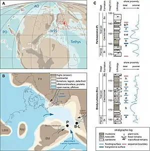
The Ciechocinek Formation on the Polish Basin mainly represents a large and shallow brackish embayment, with a lower part deposited in a restricted offshore environment, with lagoonal, deltaic and other seashore deposits, that translates to a deeper, nearly fully-marine environment in the Pomeranian region.[58] Concretely the Ciechocinek Formation was a basin that covered the nearshore deposits of the Eastern and North Bohemian Massif and the southwest margin of Fennoscandia[59] On Parkoszowice the shores of the Eastern Bohemian Massif ended on a large delta, where organic matter and trunks were deposited.[59] This zone has more developed aquatic conditions with a marked marine influence, where the presence of a river coming from Czech Republic, as the organic matter that was translated to the shore was more probably derived from thermally mature sediments, Carboniferous strata present on the Eastern Margin of the Massif.[59] The Brody-Lubienia borehole represented the coastal section of the Fennoscandinavian shield, with also river deltas, but with a stronger terrestrial influence, and with the river eroded material coming from Ordovician/Silurian black shales from Lublin.[59]
In the Polish basin, it has recently been found (based on studies of phytoclasts in terrigenous material) sharp negative anomalies (CIE) on the 13C curves, attesting to further episodes of gradually increasing warming.[60] The Presence of abundant clay on the marine deposits suggest a great flux of terrestrial facies.[58] There is a significant diagenetic overprint (especially illitization of Smectite), with burial depths up to 2000 m, with most of the studied sediments not been buried more than 1500–2000 m, which indicates that the Toarcian sediments weren't modified on a visible scale by Thermal Diagenesis.[58] The Kaolinite content of the strata on the formation is important, due to its resistance to Diageneric conditions, while on the Ciechocinek Deposits is observed that there wasn't enough diagenesis to transform the Kaolinite into Illite, with the Clay minerals are detrital and the organic matter is very immature, as palynomorphs show low thermal action.[61][58] This Kaolinite was reovered mostly on the Brody-Lubenia borehole, set on the end of a large river system.[62] On the Epicontinental Polish Basin, the Total organic carbon from the Toarcian Deposits lack connection with the Climate changes observed worldwide, with the organic carbon associated with the burial of terrestrial matter.[58] The Lower Part of the Ciechocinek Formation show conditions of sediment burial, typical under moderate climate conditions, reflected by the reduction of carbon content due to the onset of warming, maybe related with the marine flooding due to the Early Toarcian transgression, reworking the swampy lowland deposits.[61][58] During this stage there was a clear time of enhanced erosion and runoff, showed on surrounding landmasses, that result in the delivery of sediments with diverse mineralogies to the marine basin.[61][58]
The presence of green facies in the modern Polish Realm is related to an ancient ironstone paleoenvironment, with shallow marine facies that show a decreasing presence of iron.[6][61] The occurrence of this type of deposit in modern strata is related to intertropical regions in the vicinity of river mouths, where the clay mineral composition was moderately altered by the effects of local tectonic movements, sea-level changes, erosion, and recycling of ancient sediments or by hydraulic sorting during the transport and deposition.[61][63] Those relations made attribute the strata to deposition on a warm and really humid climate, with dominant swampy or marshy environments, along brackish-marine environments, consisting of lagoons, embayments, estuaries, mangroves, low-energy deltas and near sand wave fields or barrier islands, similar to the modern Caribbean Sea islands and seashore environments.[6][61]
The high presence of Kaolinite on the strata of the formation suggest a biochemical weathering in Tropical or Humid-subtropical climate with perennial rainfall, as modern Kaolinite deposits are typically present in Humid Jungle settings.[64][61][58] Finds across Europe on Toarcian strata suggest that the formation of Kaolinite in tropical soils and its deposition in marine sediments could be almost contemporaneous during the Early Jurassic in the Peritethyan Domain.[64][58] On the Suliszowice borehole was recorded a gradual mineralogical change, while on the Mechowo borehole there is a clear oscillation of the Kaolinite content, where is also recovered Milankovitch cycles, short climate variations due to the deposition of the Kaolinite on sea facies, where a change on climate conditions led to increase locally erosion and rework of pre-Jurassic Kaolinitic rocks.[64] Decreasing Kaolinite on the strata can suggest a hot but less humid climate.[64] In the middle part of the Ciechocinek Formation, as expose the abundant amount of Kaolinite show that was develop as a result of intense humidity of the environments, with the increasing presence of several fossils and minerals on the strata outside the measurements of the iron precipitation.[64][58] Organic matter is of Type III Kerogen, with fragments of microscopic plants and several traces of organic matter. Fungal material is present, where is shown how an increase on the number of specimens can be linked to the climate change on the lower Toarcian.[65] Beyond that, by the use of clay mineral data was possible to establish how the changes on the early Toarcian affected the Polish Basin: the increasing warming temperatures were measured by changes in the Kaolinite deposition on the Polish margin of the Formation, where is exposed that the subtropical climate of the region was affected by runoffs from the Tethyan realms, with the super-greenhouse/anoxic event event linked to methane expulsion.[64] There was a decline in rainfalls towards the Tenuicostatum-Falciferum boundary, exposing a transition to less humid conditions, noted by the decreasing amount of Kaolinite.[64][58]
Biota & Wildfires
The Lublin Coal Basin Flora is the main discovered on the formation. Found on the Bogdanka Coal Mine on the L-95 borehole, is dominated mainly by Bennettitales and Cycads, while Ginkgo and Cheirolepidiaceae, are subordinate, same for Ferns, where are find only large arboreal ones.[66][67] The flora is above Carboniferous strata, with conservation status of Jurassic flora is clearly different and is also different than Świętokrzyskie flora (Hettangian). The flora has detritus, forming the main components of laminae in sandstones, along numerous Lignites, that prove the occurrence of numerous fires locally.[66][67]
The organic matter found includes the oldest known Biomolecules (Labdanoic Acid, Ferruginol, Sugiol and 7-Oxototarol) from the "Blanowice brown coals", what probe the presence of abundant Wildfires and/or peat fires on the formation, with the Cupressaceae and/or Podocarpaceae families the main peat-forming plant species.[68] Posterior revision of the Lignites of the Brown Coals had revealed a major distribution of Benzohopane derivatives in these coals and surrounding sandstones, that implicate probable differences in the degree of Biodegradation, and also a low Coalification range, typical of Lignites.[69] Later largers studies cover a really big influence of the fires on the region.[42] After the Toarcian Anoxic Event on the called "Kaszewy-1" (Where the Toarcian makes ~150 m of the strata) the wildfire activity was widely recorded.[42] The great abundance of Charcoal is the main indicator of the fire activity locally, but also the Polycyclic Aromatic Hydrocarbons, whose abundance reflects an increase in wildfire activity.[42] Coarse Charcoal particles abundance is low, while the fine Charcoal particles are more abundant on nearly all the measured samples, vinculated to small reductions of the Sea Level locally.[42] The most abundant Polycyclic Hydrocarbon found locally is Phenanthrene, and along the Charcoal data shows how the Fires locally increased around the Carbon Isotope Excursion on the Toarcian Anoxic Event Worldwide.[42] Along this period, mostly of the strata of the region shows at least 6 periods of fire intensification, that are coeval to anothers found on Yorkshire, Wales and Peniche.[42]
Sporomorphs have been found, with Minerisporites richardsoni as one of the most abundant, being a genus related to Isoëtaceae. Other examples of flora include Ferns, Bennettitales ands Cycads.[70] On the recent layers there are more flora as a response to the fall of the sea level, with the presence of larger wood fragments (Baieroxylon, Simplicioxylon and Podocarpoxylon), up to 1 m long, along with trunks.[44][61] There is a high dominance of spores in the whole Polish Basin is observed on the Lower Toarcian strata, with average only 20% of bisaccate pollen grains against 80% of spores, contrasting with the other strata from older intervals of the Early Jurassic.[70] The presence of abundant spores is related to palaeoclimatic factors, as sediments show that the climate at that time was much warmer and much more humid (with a small exception on the Tenuicostatum biochronozone) than in the Hettangian-Pliensbachian interval.[70] The bisaccate pollen grain/spore ratio in the Lower Toarcian deposits in Poland is always strongly biased towards spores, which dominate even in the brackish-offshore settings.[70] The dominance of Spores was probably associated with regional climate fluctuations, associated with proximity of the West European Sea in Pomerania, and more continental climate related to higher altitudes in the East.[70] This finds are related with the Pollen and plant remains found on the Chinese Hsiangchi Formation (Also Toarcian), pointing warm and humid climate, that changed after to a drier conditions, as observed on the Quaidam Basin.[70]
Marine-Deltaic German realm
The German realm shows to be a mostly marine unit, composed by Basinal Marine to marginal marine deposits, with washed fauna from the continental deposits, where the anoxic oceanic bottom waters prevented high predatory behavior on the carcasses of most of the deceased animals. Mostly of the deposits around Grimmen, Dobbertin and others where on the Toarcian fully marine environments, that advanced towards the east forming first an enclosed inland sea in the Hettangian-Sinemurian[71] and towards the Pliensbachian-Toarcian transforming to an open shelf sea connected to both the Boreal and the Tethys Oceans.[71] The Clay Pits of Grimmen and Dobbertin tend to occur as concretions within clay to Marlstones, that are related to a pre-diagenetic carbonate migration and concentration, along early diagenetic cementation, often around organic remains.[72] The changes in the mineralogy of the environment is vinculated with the freshwater basins of Fennoscandia, draining the continent to the south. A General Moonsonal events are believed to occur on the two realms, being the main probe of it the washed insects to the sea on the German realm.[73][74] Most of the fossils come from benthonic zones[75] The marine origin of the Sediments on the German Realm are well known due to the fossil-rich carbonate concretions of the Toarcian.[76] The marine setting was regionally uniform, where sandstones were deposited as carbonate-cemented silts within fine sand lenses, which can be seen as channel fillings within the clay. Along with Ahrensburg layers are likely to show a continuous marine basin setting from Grimmen to the Baltic Sea, where marine marginal marine, to depth basin deposits occur.[76] This is also proved due to the presence of salt structures from Malchin and Dobbertin.[76] There are several strata with marine fauna, with a 15 cm thick conglomerate-like pack of Belemnites and rearranged and unrolled Ammonites along with vertebrate remains, related to an Anoxic Sea Bottom deposition, where there is also the presence of terrigenous material, including Kaolinite and several Volcanic detrits, probably coming from the Scania section of Fennoscandia, that was volcanic active during the time of deposition of the German Margin.[76]
With the presence of diagenetic carbonation that has left to an early deposition is accompanied by the presence of fine-grained sandstones and the presence of terrestrial fragments, such as dinosaur remains and plant fragments, including trunks.[77] There is a clear reduction of salinity, as probes the absence of euryhaline macroinvertebrates.[77] Depending on the interpretation of the sediments of the erratic boulders, the Ringkøbing-Fyn Island may have also played a role as a sediment source. Most of the washed sediments can have come also from the Polish realm and the seashore formations of Bornholm. There is a visible correlation between the sandstones and conglomerates from the Rya Formation. The Sorthat Formation shows clearly prodeltaic facies, part of the large Toarcian–Bajocian deltaic systems, that come from Sweden and the Polish Realm.[77]
The large Toarcian–Bajocian deltaic systems locally where the shoreline influenced by the vicinity between brackish to freshwater and continental biofacies.[78][79] The North German Basin shows that on approximately 14.4 m.a, four third-order relative sea-level fluctuations led the subsequent formation of four individual delta generations in the Bifrons-Thouarsense (Toarcian), Murchisonae-Bradfordensis (Aalenian) and Humpresianum-Garatiana (Bajocian).[78] The Toarcian section was dominated by regressive elongated river-dominated deltas, where due to the fall of the sea level the south to southwest directed delta progradation between the Lower-Upper Toarcian, that was deposited as 40 m of deltaic successions, found on places like Prignitz (East) and Brandenburg (North).[78] On the Bifrons zone (180.36-178.24 m.a) to the Thouarense zone (176.23-174.97 m.a) there was the final outbuilding of the local delta plains, where there was a stretching of about 200 km from the northern margins of the basin to the center.[78] The Toarcian local deltas are mostly regressive or constructive, with a characterised elongate morphology, covering with its plains approximately 15,000 km2 (Bifrons) to 20,000 km2 (Thouarsense).[78] The Upper deltaic plains lack any marine influence, with biofacies composed mostly by Palynomorphs, where in the southwest the lower part of the plains shows the influence of temporal marine incursions. The lower plain of the delta covered approx. 10,000 km2 (Bifrons).[78] The deltas where connected with several networks of delatic channel belts, where on zones like Usedom (Northeast) there is a clear path with bifurcations and reunification of the channel belts.[78] On the lower delta plain lithofacies plant detritus and wood debris are very common, deposited probably on interdistributary bays formed embayments, thanks to overbank flooding from near distributaries, that covered approx. 2000 km2 (Bifrons).[78]
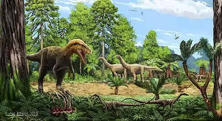
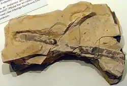
Paleofauna
Insects are abundant on the German realm, including collections of up to 3000 specimens.[80] In contrast to the famous Posidonia Shale, considerably fewer vertebrates are known from coeval sediments and most in northeastern Germany. Recent works on the pits have reveal several vertebrate fauna, including fishes, crocodrylomorphs, gravisaurians and others.[81] Of the invertebrate fauna insects,[82][83] bivalves, sea snails and ammonites (Genus Tiltoniceras, Eleganticeras and Lobolytoceras) have been found. The vertebrate fauna is also varied, with fossils of the fish genus Saurorhynchus,[84] and the new genus Grimmenichthys[85] and Grimmenodon.[86] Marine reptiles include Ichthyosauria[75][77] indet., indeterminate Plesiosauria,[75][77] and rhomaleosaurid[75][77] plesiosaurs. Crocodyliformes include indeterminate Mesoeucrocodylia[75][77] (probably Goniopholididae) and indeterminate Thalattosuchia.[75][77] Dinosaur taxa from the formation includes at least two gravisaurian sauropods,[87] probably an Averostran theropod,[88] and the thyreorphoran Emausaurus.[89] On the Polish realm the fauna is represented by Conchostracans, rare Foraminifera and scarce Ostracoda as the main components, with occasional undetermined Bivalves, Gastropods and Fish teeth & scales.[90] and various ichnospecies of vertebrate and invertebrate fauna. Invertebrates include mostly marine organisms, such as Planolites (Worm-like animals), Palaeophycus (Polychaeta), Protovirgularia (Nuculoidea) and Spongeliomorpha (Decapoda).
See also
- List of fossiliferous stratigraphic units in Germany
- List of fossiliferous stratigraphic units in Poland
- Toarcian turnover
- Toarcian formations
- Marne di Monte Serrone, Italy
- Calcare di Sogno, Italy
- Irlbach Sandstone, Germany
- Sachrang Formation, Austria
- Saubach Formation, Austria
- Blanowice Formation, Southern Poland
- Krempachy Marl Formation, Poland and Slovakia
- Djupadal Formation, Central Skane
- Lava Formation, Lithuania
- Azilal Group, North Africa
- Whitby Mudstone, England
- Fernie Formation and Poker Chip Shale, Alberta and British Columbia
- Whiteaves Formation, British Columbia
- Navajo Sandstone, Utah
- Los Molles Formation, Argentina
- Mawson Formation, Antarctica
- Kandreho Formation, Madagascar
- Kota Formation, India
- Cattamarra Coal Measures, Australia
References
- Menning, M., Pieńkowski, G., Käding, K. C., Maletz, J., Kemnitz, H., Kramer, W., ... & Hiß, M. (2020). Korrekturen und Ergänzungen zur Stratigraphischen Tabelle von Deutschland 2016 (STD 2016). Zeitschrift der Deutschen Gesellschaft für Geowissenschaften.
- Pieñkowski, G. (2004). The epicontinental Lower Jurassic of Poland. Polish Geological Institute Special Papers, 12, 1–154.
- Rózycki S.Z., 1958 — Dolna jura poludniowych Kujaw. Biul. Inst. Geol., 133: 1–99.
- Barth, G., Pieńkowski, G., Zimmermann, J., Franz, M., & Kuhlmann, G. (2018) Palaeogeographical evolution of the Lower Jurassic: high-resolution biostratigraphy and sequence stratigraphy in the Central European Basin. Geological Society, London, Special Publications, 469(1), 341–369
- Gripp, K. (1933) Geologie von Hamburg: und seiner näheren und weiteren Umgebung. Ges. d. Freunde d. Vaterländischen Schul-und Erziehungswesen
- Leonowicz, P. (2005) The Ciechocinek Formation (Lower Jurassic) of SW Poland: petrology of green clastic rocks. Geological Quarterly, 49(3), 317-330
- Leonowicz, P. (2007). Origin of siderites from the Lower Jurassic Ciechocinek Formation from SW Poland. Geological Quarterly, 51(1), 67–78
- Ansorge, J. (2007). Lower Jurassic clay pit of Klein Lehmhagen near Grimmen. The Central European Basin System–from the Bottom to the Top. Geo-Pomerania, Szczechin, 37–41.
- Ernst, W. 1991. Der Lias im Ton-Tagebau bei Grimmen (Vorpommern). Fundgrube 27: 171–183.
- Stolley, E. (1909). Über den oberen Lias und den unteren Dogger Norddeutschlands.
- Ernst, W. 1992. Der Lias der Scholle von Dobbertin (Mecklenburg). Fundgrube 28: 56–70.
- Geinitz, F. E. (1904). Die Entwicklung der mecklenburgischen Geologie: Rede zur Feier des 28. Februar 1904. Druck der Ratsbuchdruckerei von C. Michaal.
- Mönnig E, Franz M, Schweigert G. 2018. Der Jura in der Stratigraphischen Tabelle von Deutschland (STD 2016)/The stratigraphic chart of Germany (STD 2016): jurassic. ZDGG. 169:225–246.
- Zessin, W. (2010). The Dobbertine Jura (Lias ε, Mecklenburg) and its importance for paleoentomology. Virgo, newsletter of the Entomological Association Mecklenburg , 13 (1), 4–9.
- Geinitz, E. 1879: I. Beitrag zur Geologie Mecklenburgs. -Arch. Nat. Meckl. 33: 209-305
- Geinitz, E. 1915: Die Namen der mecklenburgischen Solle. Mecklenburg-Zeitschrift des Heimatbundes Mecklenburg 10: 14–28
- Kalettka, T. (1996). Die Problematik der Sölle (Kleinhohlformen) im Jungmoränengebiet Nordostdeutschlands. Naturschutz und Landschaftspflege in Brandenburg, Sonderheft, 4-12.
- Geinitz, F. E. (1894). Die Käferreste des Dobbertiner Lias. Archiv des Vereins der Freunde der Naturgeschichte in Mecklenburg, 48(1), 71–78.
- Geinitz, F. E. (1922). Geologie Mecklenburgs: mit geologischer Übersichtskarte von Mecklenburg (Vol. 1). Verlag von Carl Hinstorffs Hofbuchdruckerei.
- Ernst, W. (1992). Der Lias der Scholle von Dobbertin (Mecklenburg). Fundgrube, 28(2), 57–70.
- Ansorge, J., & Schlüter, T. (1990). The earliest chrysopid: Liassochrysa stigmatica ng, n. sp. from the Lower Jurassic of Dobbertin, Germany. Neuroptera International, 6(2), 87-93.
- Ansorge, J. (2004). Insekten aus Liasgeoden der Ahrensburger Geschiebesippe–mit einem Ausblick auf lokale Anreicherungen von Liasgeoden in Mecklenburg-Vorpommern. Archiv für Geschiebekunde, 3(8/12), 779–784.
- Ansorge, J., & Obst, K. (2015). Lias clay pit near Dobbertin. A. Börner, R.-O. Niedermeyer, and K. Schütze (eds.) , 79 , 227–240.
- Schlünz, F. K. (1935). Eine mikroskopische, röntgenographische und chemische Untersuchung des Liastons von Dobbertin. Chemie der Erde, 10, 116-125.
- Bergelin, I., Obst, K., Söderlund, U., Larsson, K., & Johansson, L. (2011). Mesozoic rift magmatism in the North Sea region: 40 Ar/39 Ar geochronology of Scanian basalts and geochemical constraints. International Journal of Earth Sciences, 100(4), 787-804.
- Lorenz, Sebastian, & Schult, Manuela (2004). Das Durchbruchstal der Mildenitz bei Dobbertin (Mecklenburg)–Untersuchungen zur spätglazialen und holozänen Talentwicklung an Terrassen und Schwemmfächern. Meyniana, 56, 47-68.
- Fuchs, A., & Zimmerle, W. (1991). Zur Bedeutung des Lias-Aufschlusses von Dobbertin (Mecklenburg)–unter Betrachtung vorläufiger tonmineralogischer Untersuchungen. Geschiebekunde aktuell, 7, 179–186.
- Malzahn, E. (1937). Die Geologie des Dobbertiner Lias und seiner Umgebung. Mitt. Mecklenb. geol. Landesamt, Rostock, 46, 1–16.
- Ansorge, J. (1996). Insekten aus dem oberen Lias von Grimmen (Vorpommern, Norddeutschland) (Vol. 2). CPress.
- Lewiñski J. 1928 – Jura i kajper w g³êbokim wierceniu w Czêstochowie. Spraw. Pos. Tow. Nauk. Warsz., 21 (3–5): 99–111
- Samsonowicz, J. (1954). Wyniki hydrogeologiczne dwu głebokich wierceń w Ciechocinku: Hydrogeologic results of two deep drillings in Ciechocinek (North-West Poland). Wydawn. geologiczne.
- Znosko, J. (1959). Wstępny zarys stratygrafii utworów jurajskich w południowo-zachodniej części Niżu polskiego. Geological Quarterly, 3(3), 501–528.
- Deczkowski, Z. (1962). Stratygrafia i litologia liasu na obszarze kalisko-częstochowskim. Geological Quarterly, 6(1), 50–71.
- Nielubowicz, B. (1963). Przyczynek do poznania okruszcowania uranowego w węglach warstw radwanickich na Dolnym Śląsku. Geological Quarterly, 7(1), 114–130.
- Żelichowski, A. M. (1966). sedymentologicznych materiału rdzeniowego na przykładzie utworów karbońskich z Ostrzeszowa. Kwartalnik geologiczny, 10(3), 742.
- Marcinkiewicz, T. (1973). Otozamites falsus (Bennettitales) from the Upper Liassic of the Holy Cross Mts, Poland. Acta Palaeontologica Polonica, 18(2).
- Dadlez, R. (1978). Stan litostratygrafii epikontynentalnej dolnej jury w Polsce i propozycje jej usystematyzowania. Geological Quarterly, 22(4).
- Rogalska, M. et al. (1980) Lower Jurassic microflora. (In: Atlas Skamienialosci Przewodnich i Charakterystycznych. L.Malinowska, W.Bielecka and M.Rogalska, editors.Warsaw) [ Jura Dolna(Mikroflora). (In: Atlas Skamienialosci Przewodnich i Charakterystycznych. L.Malinowska, W.Bielecka and M.Rogalska, editors.Warsaw) ] Budowa Geologiczna Polski Vol. 3 # 2 pp. 52–97
- Deczkowski, Z., & Franczyk, M. (1988). Paleomiąższość, litofacje i paleotektonika noryku i retyku na Niżu Polskim. Geological Quarterly, 32(1), 93–104.
- Racki, G. (2017). Artykuły Informacyjne Portal prezentujący kościonośny kajper Górnego Śląska w świetle wyników grantu N307 11703. Przegląd Geologiczny, 65(5), 275–281.
- Wyrwicki, R. (1964). Sferolity retyku i liasu świętokrzyskiego. Przegląd Geologiczny, 12(3), 134.
- Pointer, R. (2019). Fire & Global Change During Key Intervals of the Late Triassic & Early Jurassic with a Focus on the Central Polish Basin.
- Leonowicz, P. M. (2016). Tubular tempestites from Jurassic mudstones of southern Poland. Geological Quarterly, 60(2), 385-394.
- Leonowicz, P. (2011). Sedimentation of Lower Toarcian (Lower Jurassic) brackish deposits from the Częstochowa-Wieluń region (SW Poland). Acta Geologica Polonica, 61(2), 215-241.
- Czapowski, G., Dadlez, R., Feldman-Olszewska, A., Gortyńska, S., Jaskowiak-Schoeneichowa, M., Kasiński, J. R., ... & Znosko, J. (2014). Szczegółowy profil litologiczno-stratygraficzny.
- Marek, S., KasińsKi, J., Krassowska, A., Leszczyński, K., Niemczycka, T., Feldman-Olszewska, A., ... & Gajewska, I. (2018). Szczegółowy profil litologiczno-stratygraficzny.
- Jurkiewiczowa, I. (1967). Lias zachodniego obrzeżenia Gór Świętokrzyskich i jego paralelizacja z liasem Wyżyny Krakowsko-Częstochowskiej. Biul. Inst. Geol, 200, 5-132.
- Dembowska, J. (1959). Zarys stratygrafii liasu i doggeru w okolicy Szubina. Przegląd Geologiczny, 7(6), 265.
- Stemulak, J. (1957). Komunikat o wierceniu Płońsk 1. Geological Quarterly, 1(2), 268-274.
- Jurkiewicz, H. (1965). Profil wiercenia w Bożej Woli. Przegląd Geologiczny, 13(9), 378.
- Znosko, J. (1962). W sprawie stratygrafii otworów w Lidzbarku Warmińskim i Labiawie. Przegląd Geologiczny, 10(6), 280.
- Areń, B. (1965). Wyniki wiercenia Warszawa IG-1. Przegląd Geologiczny, 13(9), 369.
- Kozydra, Z. (1960). Zarys wykształcenia litologicznego serii "ciechocińskiej" liasu w rejonie Przysuchej. Przegląd Geologiczny, 8(9), 456.
- Osika, R. (1958). Profil górnego liasu i doggeru okolic Złotowa. Geological Quarterly, 2(4), 765-784.
- Karaszewski, W. (1960). Nowy podział liasu świętokrzyskiego. Geological Quarterly, 4(4), 899-920.
- Brański, P. (2010). Geneza osadów ilastych formacji ciechocińskiej (jura dolna, toark) w południowej Polsce a ich znaczenie gospodarcze. Biuletyn Państwowego Instytutu Geologicznego, (439 (2)), 249-258.
- FELDMAN-OLSZEWSKA, A. N. N. A., ADAMCZAK-BIAŁY, T. E. R. E. S. A., & BECKER, A. (2012). Charakterystyka poziomów zbiornikowych i uszczelniających formacji jury i triasu północnego Mazowsza pod kątem geologicznego składowania CO2 na podstawie danych z głębokich otworów wiertniczych. Biuletyn Państwowego Instytutu Geologicznego, 448(1), 27-46.
- Brański, P. (2012). The mineralogical record of the Early Toarcian stepwise climate changes and other environmental variations (Ciechocinek Formation, Polish Basin). Volumina Jurassica, 10(10), 1–24.
- Ruebsam, W., Pieńkowski, G., & Schwark, L. (2020). Toarcian climate and carbon cycle perturbations–its impact on sea-level changes, enhanced mobilization, and oxidation of fossil organic matter. Earth and Planetary Science Letters, 546, 116417.
- Branski, P.(2012):Mineralogiczny Zapis Efektu Cieplarnianego W osadach dolnego Toarku W Basenie Polskim. Jurassica X Conference. Pañstwowy Instytut Geologiczny – Pañstwowy Instytut Badawczy, ul. Rakowiecka 4, 00-975 Warszawa
- Brański, P. (2011). Clay mineral composition in the Triassic and Jurassic deposits from the Polish Basin–a record of palaeoclimatic and palaeoenvironmental changes. Biuletyn Państwowego Instytutu Geologicznego, 444, 15-32.
- Brański, P. (2008). Epizody kaolinitowe w profilu Brody--Lubienia-zapis efektu cieplarnianego (?) we wczesnym toarku. Geologia/Akademia Górniczo-Hutnicza im. Stanisława Staszica w Krakowie, 34, 165-166.
- Pieńkowski, G., Brański, P., 2019: Palaeoclimatic and palaeoenvironmental significance of the clay minerals from the Lower Jurassic (and Rhaetian) in Kaszewy 1 borehole (central part of the Mid-Polish Trough). JURASSICA XIII. abstract volume
- Brański, P. (2010). Kaolinite peaks in early Toarcian profiles from the Polish Basin–an inferred record of global warming. Geological Quarterly, 54(1), 15-24.
- Pieńkowski, G., Hodbod, M., & Ullmann, C. V. (2016). Fungal decomposition of terrestrial organic matter accelerated Early Jurassic climate warming. Scientific reports, 6(1), 1–11.
- Migier T. 1978. Nowe stanowiska flory jurajskiej w Lubelskim Zagłębiu Węglowym. Materiały III Naukowej Konferencji Paleontologów poświęconej badaniom regionu górnośląskiego oraz karbonu LZW i GZW. Streszczenia komunikatów: 33–34.Uniwersytet Śląski, Katowice.
- Szydeł, Z., & Szydeł, R. (1981). Profil utworów liasu na obszarze Lubelskiego Zagłębia Węglowego. Przegląd Geologiczny, 29(11), 568-571.
- Rybicki, M., Marynowski, L., Misz-Kennan, M., & Simoneit, B. R. T. (2016). Molecular tracers preserved in Lower Jurassic "Blanowice brown coals" from southern Poland at the onset of coalification: Organic geochemical and petrological characteristics. Organic Geochemistry, 102, 77–92. doi:10.1016/j.orggeochem.2016.09.012
- Rybicki, M., Marynowski, L., & Simoneit, B. R. (2017). Benzohopane Series, Their Novel Di-, Tri-, and Tetraaromatic Derivatives, and Diaromatic 23-and 24-Norbenzohopanes from the Lower Jurassic Blanowice Formation, Southern Poland. Energy & Fuels, 31(3), 2617-2624.
- Pieñkowski, G., & Waksmundzka, M. (2009). Palynofacies in Lower Jurassic epicontinental deposits of Poland: tool to interpret sedimentary environments. Episodes, 32(1), 21-32.
- Lott, G.K., Wong, T.E., Dusar, M., Andsbjerg, J., Mönnig, E., Feldman-Olszewska, A. & Verreussel, R.M.C.H. 2010. Jurassic. In: Doornenbal, J.C. & Stevenson, A.G. (eds) Petroleum Geological Atlas of the Southern Permian Basin Area. European Association of Geoscientists and Engineers (EAGE), Houten, The Netherlands, 175–193
- Lierl, H.-J. 1990. Die Ahrensburger Geschiebesippe. Fossilien, 7, 256–267.
- Maisch, M. W., & Ansorge, J. (2004). The Liassic ichthyosaurStenopterygius cf. quadriscissus from the lower Toarcian of Dobbertin (northeastern Germany) and some considerations on lower Toarcian marine reptile palaeobiogeography. Paläontologische Zeitschrift, 78(1), 161-171.
- Lehmann, U. (1968). Stratigraphie und Ammonitenführung der Ahrensburger Glazial-Geschiebe aus dem Lias epsilon (= Unt. Toarcium). Mitteilungen aus dem Geologischen Staatsinstitut in Hamburg, 37, 41-68.
- Stumpf, S. (2017). A Synoptic Review of the Vertebrate Fauna from the "Green Series" (Toarcian) of Northeastern Germany with Descriptions of New Taxa: A Contribution to the Knowledge of Early Jurassic Vertebrate Palaeobiodiversity Patterns (Doctoral dissertation, Mathematisch-Naturwissenschaftliche Fakultät der Ernst-Moritz-Arndt-Universität Greifswald)
- Ansorge, J. & Grimmebergen, G. (2016):Grätensandsteine und andere Geschiebe des oberen Lias (Toarcium) aus Norddeutschland [Upper Liassic sandstones with fish remains (so-called Grätensandsteine) and other Toarcian glacial erratics from northern Germany]. Geschiebekunde aktuell 32 (4): 121-141, 12 Abb
- Sachs, S., Hornung, J. J., Lierl, H. J., & Kear, B. P. (2016). Plesiosaurian fossils from Baltic glacial erratics: evidence of Early Jurassic marine amniotes from the southwestern margin of Fennoscandia. Geological Society, London, Special Publications, 434(1), 149–163.
- Zimmermann, J., Franz, M., Schaller, A., & Wolfgramm, M. (2017). The Toarcian-Bajocian deltaic system in the North German Basin: Subsurface mapping of ancient deltas-morphology, evolution and controls. Sedimentology, 65(3), 897–930. doi:10.1111/sed.12410
- Barth, G., Pieńkowski, G., Zimmermann, J., Franz, M., & Kuhlmann, G. (2018). Palaeogeographical evolution of the Lower Jurassic: high-resolution biostratigraphy and sequence stratigraphy in the Central European Basin. Geological Society, London, Special Publications, 469(1), 341-369.
- Ansorge, J. (2003). Insects from the lower Toarcian of middle Europe and England. Acta zoologica cracoviensia, 46(SUPPL.), 291–310.
- Zessin, W., & Krempien, W. (2010). Bemerkenswerte Saurier-, Krokodil-und Fischfunde aus dem Lias von Grimmen, Vorpommern. Geschiebekunde Aktuell Sonderheft, 8, 5-18.
- Rasnitsyn, AP, Ansorge, J., & Zessin, W. (2003). New hymenopterous insects (Insecta: Hymenoptera) from the Lower Toarcian (Lower Jurassic) of Germany. New yearbook for geology and paleontology treatises , 321–342.
- Ansorge, J. (1996). Zur systematischen Position vonSchesslitziella haupti Kuhn 1952 (Insecta: Phasmatodea) aus dem Oberen Lias von Nordfranken (Deutschland). Paläontologische Zeitschrift, 70(3-4), 475-479.
- E. E. Maxwell and S. Stumpf. 2017. Revision of Saurorhynchus (Actinopterygii: Saurichthyidae) from the Early Jurassic of England and Germany. European Journal of Taxonomy 321:1-29
- M. Konwert and M. Hörnig. 2018. Grimmenichthys ansorgei, gen. et sp. nov. (Teleostei, 'Pholidophoriformes'), and other 'pholidophoriform' fishes from the early Toarcian of Grimmen (Mecklenburg-Western Pomerania, Germany). Journal of Vertebrate Paleontology 38:e1451871
- S. Stumpf, J. Ansorge, C. Pfaff and J. Kriwet. 2017. Early Jurassic diversification of pycnodontiform fishes (Actinopterygii, Neopterygii) after the end-Triassic extinction event: evidence from a new genus and species, Grimmenodon aureum. Journal of Vertebrate Paleontology 37:e1344679
- S. Stumpf, J. Ansorge, and W. Krempien. 2015. Gravisaurian sauropod remains from the marine late Early Jurassic (Lower Toarcian) of North-Eastern Germany.
- F. v. Huene. 1966. Ein Megalosauriden-Wirbel des Lias aus norddeutschem Geschiebe [A megalosaurid vertebra from the Lias of a north German boulder]. Neues Jahrbuch für Geologie und Paläontologie 1966(5):318–319
- Haubold, H. 1990. Ein neuer Dinosaurier (Ornithischia, Thyreophora) aus dem Unteren Jura des nördlichen Mitteleuropa. Revue de Paleobiologie 9(1):149–177. [In German]
- Kopik, J. (1998). Lower and Middle Jurassic of the north-eastern margin of the Upper Silesian Coal Basin. Biuletyn Państwowego Instytutu Geologicznego, 378, 67-129.