Balaguier-sur-Rance
Balaguier-sur-Rance is a commune in the Aveyron department in the Occitanie region of southern France.
Balaguier-sur-Rance | |
|---|---|
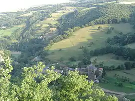 Balaguier-sur-Rance seen from the nearby hillside | |
Location of Balaguier-sur-Rance 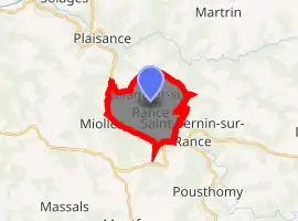
| |
 Balaguier-sur-Rance  Balaguier-sur-Rance | |
| Coordinates: 43°53′55″N 2°34′39″E | |
| Country | France |
| Region | Occitanie |
| Department | Aveyron |
| Arrondissement | Millau |
| Canton | Causses-Rougiers |
| Intercommunality | Pays Saint-Serninois |
| Government | |
| • Mayor (2014–2020) | David Maury |
| Area 1 | 9.8 km2 (3.8 sq mi) |
| Population (2017-01-01)[1] | 92 |
| • Density | 9.4/km2 (24/sq mi) |
| Time zone | UTC+01:00 (CET) |
| • Summer (DST) | UTC+02:00 (CEST) |
| INSEE/Postal code | 12019 /12380 |
| Elevation | 253–748 m (830–2,454 ft) (avg. 271 m or 889 ft) |
| 1 French Land Register data, which excludes lakes, ponds, glaciers > 1 km2 (0.386 sq mi or 247 acres) and river estuaries. | |
The inhabitants of the commune are known as Balaguiérois or Balaguiéroises.[2]
Geography
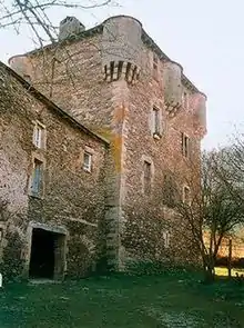
Balaguier-sur-Rance is located some 32 km east of Albi and just north of Saint-Sernin-sur-Rance. The whole western border of the commune is the departmental boundary between Aveyron and Tarn. The commune is divided into two parts situated on either side of the Rance river. Balaguier le Maigre (the thin) or le Vieux (the old) is on the right bank with its houses clinging to a rocky outcrop that supported a fortified structure of which there remains no trace. On the left bank is Balaguier le Gras (the fat) with the church, the town hall, and a chateau from the 15th and 16th centuries. Both banks are connected by a stone bridge from the 15th century. Access to the commune is by the D33 road from Curvalle in the north-west which passes through the commune and the village and joins the D999 on the communal border then continues to Saint-Sernin-sur-Rance. The D999 passes through the south of the commune as it goes from Alban to Vabres-l'Abbaye.[3]
The Rance river flows through the centre of the commune from east to west where it continues north-west to join the Tarn east of Trébas. Many tributaries rise in the commune on both banks of the Rance and flow into it.[3]
Administration
| From | To | Name | Party | Position |
|---|---|---|---|---|
| 1846 | 1870 | Pierre Cadas | ||
| 1870 | 1876 | Casimir Guy | ||
| 1876 | 1902 | Pierre Sylvain Frédéric Villeneuve | ||
| 1902 | 1904 | Auguste Louis Cadas | ||
| 1995 | 2014 | Philippe Boularan | ||
| 2014 | 2020 | David Maury |
(Not all data is known)
Demography
In 2017 the commune had 92 inhabitants.
|
| |||||||||||||||||||||||||||||||||||||||||||||||||||||||||||||||||||||||||||||||||||||||||||||||||||
| Source: EHESS[5] and INSEE[6] | ||||||||||||||||||||||||||||||||||||||||||||||||||||||||||||||||||||||||||||||||||||||||||||||||||||
Sites and monuments
Notable people linked to the commune
- Hippolyte Coste, born 20 December 1858 in Balaguier-sur-Rance at Mas d'Estioussès.
See also
References
- "Populations légales 2017". INSEE. Retrieved 6 January 2020.
- Inhabitants of Aveyron (in French)
- Google Maps
- List of Mayors of France (in French)
- Des villages de Cassini aux communes d'aujourd'hui: Commune data sheet Balaguier-sur-Rance, EHESS. (in French)
- Population en historique depuis 1968, INSEE
External links
- Balaguier-sur-Rance on the old National Geographic Institute website (in French)
- Balaguier-sur-Rance on Lion1906
- Balaguier-sur-Rance on Géoportail, National Geographic Institute (IGN) website (in French)
- Balaguier on the 1750 Cassini Map
| Wikimedia Commons has media related to Balaguier-sur-Rance. |
| Authority control |
|---|