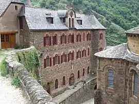
Conques-en-Rouergue
Conques-en-Rouergue is a commune in the department of Aveyron, southern France. It lies on the Lot river. The municipality was established on 1 January 2016 by merger of the former communes of Conques, Grand-Vabre, Noailhac and Saint-Cyprien-sur-Dourdou.[2]
Conques-en-Rouergue | |
|---|---|
 | |
Location of Conques-en-Rouergue 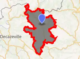
| |
 Conques-en-Rouergue  Conques-en-Rouergue | |
| Coordinates: 44°35′56″N 2°23′53″E | |
| Country | France |
| Region | Occitanie |
| Department | Aveyron |
| Arrondissement | Rodez |
| Canton | Lot et Dourdou |
| Area 1 | 106.23 km2 (41.02 sq mi) |
| Population (2017-01-01)[1] | 1,673 |
| • Density | 16/km2 (41/sq mi) |
| Time zone | UTC+01:00 (CET) |
| • Summer (DST) | UTC+02:00 (CEST) |
| INSEE/Postal code | 12076 /12320 |
| 1 French Land Register data, which excludes lakes, ponds, glaciers > 1 km2 (0.386 sq mi or 247 acres) and river estuaries. | |
Further reading
- Parayre, Henry (1951). Conques-en-Rouergue... son église, son trésor. Toulouse: Imprimerie du Sud-Ouest. OCLC 465841464.
References
- "Populations légales 2017". INSEE. Retrieved 6 January 2020.
- Arrêté préfectoral 19 November 2015 (in French)
See also
| Authority control |
|---|
This article is issued from Wikipedia. The text is licensed under Creative Commons - Attribution - Sharealike. Additional terms may apply for the media files.