Belcastel, Aveyron
Belcastel (Bèl Castèl in Occitan) is a commune in the Aveyron department in southern France.
Belcastel | |
|---|---|
_pont.jpg.webp) 15th-century bridge | |
.svg.png.webp) Coat of arms | |
Location of Belcastel 
| |
 Belcastel  Belcastel | |
| Coordinates: 44°23′22″N 2°20′16″E | |
| Country | France |
| Region | Occitanie |
| Department | Aveyron |
| Arrondissement | Villefranche-de-Rouergue |
| Canton | Enne et Alzou |
| Intercommunality | Pays Rignacois |
| Government | |
| • Mayor (2008–2014) | Claude Cayla |
| Area 1 | 10.74 km2 (4.15 sq mi) |
| Population (2017-01-01)[1] | 191 |
| • Density | 18/km2 (46/sq mi) |
| Time zone | UTC+01:00 (CET) |
| • Summer (DST) | UTC+02:00 (CEST) |
| INSEE/Postal code | 12024 /12390 |
| Elevation | 391–707 m (1,283–2,320 ft) (avg. 450 m or 1,480 ft) |
| 1 French Land Register data, which excludes lakes, ponds, glaciers > 1 km2 (0.386 sq mi or 247 acres) and river estuaries. | |
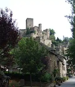
The village is medieval in character, with cobbled streets and lauze-roofed (stone tiled) houses. The bulk of the village and the castle (Château de Belcastel) are situated on the steep north bank of the Aveyron river. Several buildings including the 15th-century church are on the south side of the river, with a similarly aged bridge (pictured) connecting the two. A ruined fort, Fort du Lourdou, can also be found about a kilometre west of the village on the south bank of the river at the Roc d'Anglars. It was nominated as one of the "most beautiful villages of France" (Les Plus Beaux Villages de France), and the local council regularly hosts watercolour competitions and art exhibitions during the summer.
Population
| Year | Pop. | ±% |
|---|---|---|
| 1962 | 279 | — |
| 1968 | 280 | +0.4% |
| 1975 | 266 | −5.0% |
| 1982 | 249 | −6.4% |
| 1990 | 245 | −1.6% |
| 1999 | 251 | +2.4% |
| 2008 | 228 | −9.2% |
See also
References
- "Populations légales 2017". INSEE. Retrieved 6 January 2020.
External links
| Wikimedia Commons has media related to Belcastel (Aveyron). |
- Tourism in Belcastel
- Photographs of Belcastel
- Route des Seigneurs du Rouergue (in French)
- The Roc d'Anglars
| Authority control |
|---|