Harar
"Harar" also refers to the fruit of Terminalia chebula.
Harar
ሐረር (in Amharic)
Harar (in Oromo) هرر (in Arabic) | |
|---|---|
City | |
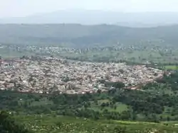 Old Harar enclosed by the jugol (defensive wall) | |
 Flag | |
| Nickname(s): City of Saints (مدينة الأَوْلِيَا) | |
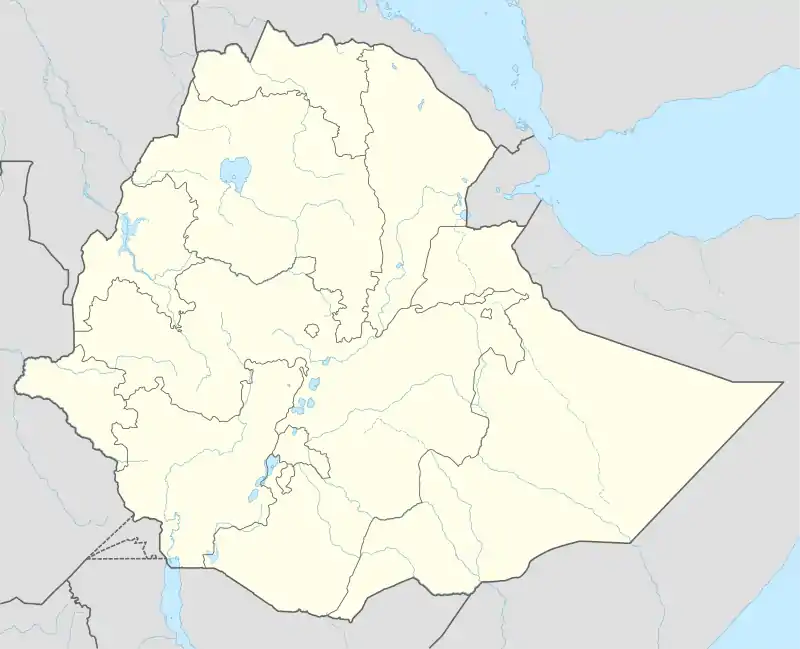 Harar Location within Ethiopia | |
| Coordinates: 9°19′N 42°7′E | |
| Country | Ethiopia |
| Region | Harari |
| Zone | East Hararghe Zone |
| Government | |
| • President | Ordin Bedri |
| Elevation | 1,885 m (6,184 ft) |
| Population (2012) | |
| • Total | 151,977 |
| Time zone | UTC+3 (EAT) |
| Official name | Harar Jugol, the Fortified Historic Town |
| Criteria | Cultural: ii, iii, iv, v |
| Reference | 1189 |
| Inscription | 2006 (30th session) |
| Area | 48 ha |
Harar (Amharic: ሐረር; ጌይ Gē "the City",[1] Oromo: Adare Biyyo [lower-alpha 1]) is a walled city in eastern Ethiopia. It is known in Arabic as the City of Saints (Arabic: مدينة الأَوْلِيَاء).
Harar is the capital of the East Hararghe Zone and the capital of the Harari Region of Ethiopia.[3] The city is located on a hilltop in the eastern extension of Oromia, about five hundred kilometers from the seat of federal Government and Oromia's capital Addis Ababa at an elevation of 1,885 metres (6,184 ft). Based on figures from the Central Statistical Agency in 2005, Harar had an estimated total population of 122,000, of whom 60,000 were male and 62,000 were female.[4] According to the census of 1994, on which this estimate is based, the city had a population of 76,378.
For centuries, Harar has been a major commercial center, linked by the trade routes with the rest of Ethiopia, the entire Horn of Africa, the Arabian Peninsula, and, through its ports, the outside world. Harar Jugol, the old walled city, was listed as a World Heritage Site in 2006 by UNESCO in recognition of its cultural heritage.[5] Because of Harar's long history of involvement during times of trade in the Arabian Peninsula, the Government of Ethiopia has made it a criminal offence to demolish or interfere with any historical sites or fixtures in the city. These include stone homes, museums and items discarded from war. According to UNESCO, it is "considered 'the fourth holiest city' of Islam" with 82 mosques, three of which date from the 10th century, and 102 shrines.[6][7]
Yahyá Naṣrallāh's Fatḥ Madīnat Harar, an unpublished history of the city in the 13th century, records that the Qadi Abadir Umar ar-Rida and several other religious leaders settled in Harar c. 1216 (612 AH).[8] Harar was later made the new capital of the Adal Sultanate in 1520 by the Sultan Abu Bakr ibn Muhammad.[9] The city saw a political decline during the ensuing Emirate of Harar, only regaining some significance in the Khedivate of Egypt period. During the Ethiopian Empire, the city decayed while maintaining a certain cultural prestige.
History
It is likely the original inhabitants of the region were the Harla people.[10] Harar was part of the Harla Kingdom's domain in the sixth century.[11][12] In the Islamic period, the city was under an alliance of confederated states of Zeila.[3] According to the twelfth-century Iberian Jewish traveler Benjamin of Tudela, the Zeila region was the land of the Havilah, confined by al-Habash in the west.[13][14]
In the ninth century, Harar was under the Maḥzūmī dynasty's Sultanate of Showa.[15][16]
The rise of Muslim Harar
Harar emerged as the center of Islamic culture and religion in the Horn of Africa during end of the Middle Ages.
According to the Fatḥ Madīnat Harar, the cleric Abadir Umar ar-Rida, along with several other religious leaders, came from the Arabian Peninsula to settle in Harar circa 612H (1216 CE). Abadir was met by the Harla, Gaturi and Argobba.[17] Abadir's brother Fakr ad-Din subsequently founded the Sultanate of Mogadishu and another one of his descendants founded the Hadiya Sultanate.[18][19]
According to the 14th century chronicles of Amda Seyon I, Gēt (Gēy) was a colony in the Harla country.[20] During the Middle Ages, Harar was part of the Adal Sultanate, becoming its capital in 1520 under Sultan Abu Bakr ibn Muhammad. The sixteenth century was the city's Golden Age. The local culture flourished, and many poets lived and wrote there. It also became known for coffee, weaving, basketry and bookbinding.
From Harar, Ahmad ibn Ibrahim al-Ghazi, also known as "Gurey" and "Grañ", both meaning "the Left-handed", launched a war of conquest in the sixteenth century that extended the polity's territory and threatened the existence of the neighboring Oriental Orthodox Christian Ethiopian Empire. His successor, Emir Nur ibn Mujahid, built a protective wall around the city.[21] Four meters in height with five gates, this structure, called the Jugol, is still intact and is a symbol of the town to the inhabitants. Siltʼe, Wolane, Halaba and Harari people lived in Harar, while the former three moved to the Gurage region.[22]
The Emirate of Harar also struck its own currency, the earliest possible issues bearing a date that may be read as 615 AH (1218/19 CE); but the first coins were definitely issued by 1789 CE, and more were issued into the nineteenth century.[23]
Elisée Reclus (1886) describes the two main ancient routes leading from Harar to Zeila, one route passing through the country of the Gadabuursi and one route passing through Issa territory, both subclans of the Dir clan family:
"Two routes, often blocked by the inroads of plundering hordes, lead from Harrar to Zeila. One crosses a ridge to the north of the town, thence redescending into the basin of the Awash by the Galdessa Pass and valley, and from this point running towards the sea through Issa territory, which is crossed by a chain of trachytic rocks trending southwards. The other and more direct but more rugged route ascends north-eastwards towards the Darmi Pass, crossing the country of the Gadibursis or Gudabursis. The town of Zeila lies south of a small archipelago of islets and reefs on a point of the coast where it is hemmed in by the Gadibursi tribe. It has two ports, one frequented by boats but impracticable for ships, whilst the other, not far south of the town, although very narrow, is from 26 to 33 feet deep, and affords safe shelter to large craft."[24]
The decline of Harar
_LCCN2014683643.jpg.webp)
Following the death of Emir Nur, Harar began a steady decline in wealth and power. A later ruler, Imam Muhammed Jasa, a kinsman of Ahmad Gragn, known as, Ahmad ibn Ibrahim al Ghazi yielded to the pressures of increasing Oromo raids and in 1577 abandoned the city, relocating to Aussa and making his brother ruler of Harar. The new base not only failed to provide more security from the Oromos, it attracted the hostile attention of the neighboring Afar people, who raided caravans traveling between Harar and the coast. The Imamate of Aussa declined over the next century while Harar regained its independence under `Ali ibn Da`ud, the founder of a dynasty that ruled the city from 1647 until 1875, when it was conquered by Egypt.[25]
Harar was very dependent on Berbera for trade since the Middle Ages. According to Richard Francis Burton, who visited both Berbera and Harar during his travels, he repeated a famous Harari saying he heard in 1854: "He who commands at Berbera, holds the beard of Harar in his hands."[26] A significant portion of the trade between the two historic towns was controlled by merchants belonging to the Habr Awal Somali clan, who also partook in the trade of the renowned Harari coffee bean, which were named Berbera Coffee in the international market.[27]
Colonialism until the present day
In 1875 Muhammad Rauf Pasha led an Egyptian force from Zeila into the interior of southeast Ethiopia, pretending to be a scientific expedition. It occupied Harar on 11 October 1875.[28] During the period of Egyptian rule (1875-1884), Arthur Rimbaud lived in the city as the local functionary of several different commercial companies based in Aden; he returned in 1888 to resume trading in coffee, musk, and skins until a fatal disease forced him to return to France. A house said to have been his residence is now a museum.[29]
In 1885, Harar regained its independence, but this lasted only two years until 6 January 1887 when the Battle of Chelenqo led to Harar's conquest by Emperor Menelik II of Ethiopia's growing empire based in Shewa.
Harar lost some of its commercial importance with the creation of the French-built Addis Ababa–Djibouti Railway, initially intended to run via the city but diverted north of the mountains between Harar and the Awash River to save money. As a result of this, Dire Dawa was founded in 1902 as New Harar. The British planned to revitalise the historic Harar-Berbera trade route by connecting the two cities via rail as a means to bolster trade. However, the initiative was vetoed by parliament on the grounds that it would harm the Entente Cordiale between France and Britain.[30]
A railway from Berbera to Harrar in Abyssinia was suggested as a means of bringing the interior of the protectorate within easy access, and at the same time of catering for the trade of Abyssinia; but it was vetoed on the ground that to compete with the French railway from Jibouti to Adis Ababa would be poor policy at a time when the entente cordiale had just been firmly cemented.[31]
.jpg.webp)
Harar was captured by Italian troops under Marshall Rodolfo Graziani during the Second Italo-Ethiopian War on 8 May 1936. The 1st battalion of the Nigeria Regiment, advancing from Jijiga by way of the Marda Pass, captured the city for the allies 29 March 1941.[32] Following the conclusion of the Anglo-Ethiopian Agreement in 1944, the government of the United Kingdom were granted permission to establish a consulate in Harar, although the British refused to reciprocate by allowing an Ethiopian one at Hargeisa. After numerous reports of British activities in the Haud that violated the London Agreement of 1954, the Ethiopian Ministry of Foreign Affairs ordered the consulate closed March 1960.[33]
In 1995, the city and its environs became an Ethiopian region (or kilil) in its own right. A pipeline to carry water to the city from Dire Dawa is currently under construction.
According to Sir Richard Burton Harar is the birthplace of the khat plant.[34] The original domesticated coffee plant is also said to have been from Harar.[35]
Climate
The climate of Harar is classified as subtropical highland climate (Cwb) in Köppen-Geiger climate classification system.
Throughout the year, afternoon temperatures are warm to very warm, whilst mornings are cool to mild. Rain falls between March and October with a peak in August, whilst November to February is usually dry.
| Climate data for Harar | |||||||||||||
|---|---|---|---|---|---|---|---|---|---|---|---|---|---|
| Month | Jan | Feb | Mar | Apr | May | Jun | Jul | Aug | Sep | Oct | Nov | Dec | Year |
| Average high °C (°F) | 25.3 (77.5) |
26.3 (79.3) |
27.1 (80.8) |
26.9 (80.4) |
27.0 (80.6) |
25.5 (77.9) |
23.8 (74.8) |
22.6 (72.7) |
23.9 (75.0) |
26.1 (79.0) |
25.8 (78.4) |
25.8 (78.4) |
25.5 (77.9) |
| Average low °C (°F) | 11.9 (53.4) |
12.9 (55.2) |
13.7 (56.7) |
14.5 (58.1) |
14.6 (58.3) |
14.1 (57.4) |
14.0 (57.2) |
13.6 (56.5) |
13.5 (56.3) |
13.1 (55.6) |
12.1 (53.8) |
12.0 (53.6) |
13.3 (56.0) |
| Average rainfall mm (inches) | 17 (0.7) |
20 (0.8) |
57 (2.2) |
84 (3.3) |
91 (3.6) |
68 (2.7) |
99 (3.9) |
126 (5.0) |
94 (3.7) |
49 (1.9) |
12 (0.5) |
6 (0.2) |
723 (28.5) |
| Source: Climate-Data[36] | |||||||||||||
Demographics
According to the latest census Harar city has close to 100,000 residents.[37]
Ethnicity
In 1855 Richard Francis Burton described Harar as having an approximately 8,000 inhabitants; 3,000 Bedouins (referring to seasonal nomads who "come and go", 2,500 Hararis, and 2,500 Somalis.[38] Burton further reported a large Oromo presence leading to the town.[39]
During his visit in the Khedivate of Egypt occupation of the Emirate of Harar, researcher Paultischke describes Harar as having roughly 40,000 inhabitants with 25,000 of these being Hararis, 6,000 Oromo, 5,000 Somalis, 3,000 Abyssinians as well as a minority of Europeans and Asians.[40]
_(14586268478).jpg.webp)
After the conquest of the Emirate of Harar by Ethiopian Empire, an influx of Amhara settled in Harar and its surroundings.[41] The Somali population of the town was decimated following the overthrow of Iyasu V by Abyssinian militias.[42]
Today the ethnic make up of the town consists of Amhara 40.5%, Oromo 28.1%, Harari 11.8% Gurage 7.9% and Somali 6.8%.[43][44][45] The indigenous Harari natives who once were majority within the walled city are under 15%, due to ethnic cleansing by the Haile Selassie regime.[46][47][48] As a result of the repression by the Ethiopian regime, in the late 1970's Hararis residing in Addis Ababa outnumbered those in Harar.[49] According to Feener, the Harari have not recovered from the 1948 state led crackdown on their population.[50]
The Somali tribes surrounding Harar are mainly from the Gadabuursi and Issa subclans of the Dir and the Karanle subclan of the Hawiye. They represent the most native Somali clans in the region.[51] The Darod clans of the Geri and Jidwaaq also inhabit areas near Harar. The Gadabuursi and Geri Somali strike immediately north and north eastwards of the town. Richard Francis Burton (1856) describes the Gadabuursi and Geri Somali clans as extending to within sight of Harar.[52][53] The Issa and Karanle Hawiye strike north and north westwards whilst the Jidwaaq strike eastwards.[54][55]
I.M. Lewis (1998) states:
"Including the land round Harar and Dire Dawa inhabited by the Somalis of the 'Iise and Gadabuursi clans."[56]
Attractions
_00.jpg.webp)
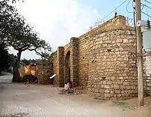
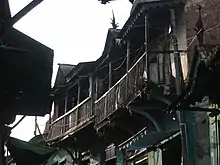
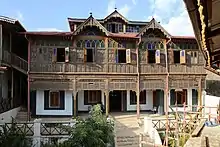
Besides the stone wall surrounding the city, the old town is home to 110 mosques and many more shrines, centered on Feres Magala square. Notable buildings include Medhane Alem Cathedral, the house of Ras Makonnen Wolde Mikael, the Monument to Ras Makonnen, sculpted by Antun Augustinčić in 1959 which has been destroyed in June 2020, the house of Arthur Rimbaud, the sixteenth century Jami Mosque and historic Great Five Gates of Harar. Harrar Bira Stadium is the home stadium for the Harrar Beer Bottling FC. One can also visit the market.
A long-standing tradition of feeding meat to spotted hyenas also evolved during the 1960s into an impressive night show for tourists.[57] (See spotted hyenas in Harar.)
Other places of interest include the highest amba overlooking the city, the Kondudo or "W" mountain, which hosts an ancient population of feral horses. A 2008 scientific mission has unleashed efforts for their conservation, as the animals are greatly endangered.[58]
The Harar Brewery was established in 1984. Its beers can be sampled at the brewery social club adjacent to the brewery in Harar.[59][60]
Intercity bus service is provided by the Selam Bus Line Share Company.
Sister cities
| Country | Town |
|---|---|
Notable residents
- 'Abd Allah II ibn 'Ali 'Abd ash-Shakur, last emir of Harar
- Abadir Umar ar-Rida, Muslim cleric
- Amha Selassie, Emperor of the Ethiopian Empire (Designate)
- Mahfuz, Imam and General of the Adal Sultanate
- Bati del Wambara, wife of Ahmad ibn Ibrahim al-Ghazi
- Nur ibn Mujahid, Emir of Harar
- Abdullah al-Harari, leader of al-Ahbash
- Malik Ambar, Leader of Ahmadnagar Sultanate
- `Ali ibn Da`ud, Founder of Emirate of Harar
- Arthur Rimbaud, the French poet, settled as a merchant in Harar between 1880 and 1891
- Haile Selassie, Emperor of Ethiopia
- Ahmad ibn Ibrahim al-Ghazi, Leader of Adal Sultanate
- Sheikh Madar Shirwa, Somali Sheikh who founded the Hargeisa Tariqa (religious commune)
- Ambassador Mohammed Abdurahman, first Harari Lawyer who graduated in McGill university.
- Mr Abdusamad Idris, Harari historian
See also
- East Hararghe
- West Hararghe
- Dire dawa
- Harar Brewery
- Coffee production in Harar
- Harari language
- Harari people
- Hargeisa, a city in Somaliland also called "Little Harar"
- Islam in Ethiopia
- Project Harar
- Silt'e people, an ethnic claiming to originate from Harar
- List of World Heritage Sites in Ethiopia
Notes
- Formerly written as Harrar, [2] other variants include Hārer and Harer.
- Leslau, Wolf (1959). "An Analysis of the Harari Vocabulary". Annales d'Ethiopie. 3: 275. doi:10.3406/ethio.1959.1310.
- Chisholm, Hugh, ed. (1911). . Encyclopædia Britannica. 18 (11th ed.). Cambridge University Press. p. 16.
- Wehib, Ahmed (October 2015). History of Harar and Harari (PDF). Harari people regional state, culture, heritage and tourism bureau. p. 5.CS1 maint: date and year (link)
- CSA 2005 National Statistics, Table B.4
- "Panda sanctuary, tequila area join UN World Heritage sites". Un.org. 2006-07-13. Retrieved 2013-07-23.
- "Harar Jugol, the Fortified Historic Town". World Heritage List. UNESCO World Heritage Centre. Retrieved 6 August 2009.
It is considered 'the fourth holy city' of Islam, having been founded by a holy missionary from the Arabic Peninsula.
- "Five new heritage sites in Africa". BBC. July 13, 2006. Retrieved 2006-12-18.
Harar Jugol, seen as the fourth holiest city of Islam, includes 82 mosques, three of which date from the 10th Century, and 102 shrines.
- Siegbert Uhlig, Encyclopaedia Aethiopica: He-N, Volume 3, (Otto Harrassowitz Verlag: 2007), pp.111 & 319.
- Richard Pankhurst, History of Ethiopian Towns (Wiesbaden: Franz Steiner Verlag, 1982), p. 49.
- Gebissa, Ezekiel (2004). Leaf of Allah: Khat & Agricultural Transformation in Harerge, Ethiopia 1875-1991. Ohio State University Press. ISBN 978-0-85255-480-7., page 36
- Belayneh, Anteneh (2014). "Ethnomedicinal plants used to treat human ailments in the prehistoric place of Harla and Dengego valleys, eastern Ethiopia". Journal of Ethnobiology and Ethnomedicine. 10: 18. doi:10.1186/1746-4269-10-18. PMC 3933041. PMID 24499509.
- Insoll, Timothy. "First Footsteps in the Archaeology of Harar, Ethiopia". Journal of Islamic Archaeology.
- Adler, Elkan Nathan (2014). Jewish Travellers. Routledge. p. 61. ISBN 978-1-134-28606-5.
- The St. James's Magazine. Houlston & Wright. 1868. p. 84.
- The Ethno-History of Halaba People (PDF). p. 15. Retrieved 20 October 2017.
- Østebø, Terje (2011). Localising Salafism: Religious Change Among Oromo Muslims in Bale, Ethiopia. BRILL. p. 56. ISBN 978-90-04-18478-7.
- Braukämper, Ulrich (2002). Islamic History and Culture in Southern Ethiopia: Collected Essays. LIT Verlag Münster. ISBN 978-3-8258-5671-7., page 107
- Hassen, Mohammed (2015). The Oromo and the Christian Kingdom of Ethiopia: 1300-1700. Boydell & Brewer. p. 99. ISBN 978-1-84701-117-6.
- Luling, Virginia (2002). Somali Sultanate: The Geledi City-state Over 150 Years. Transaction Publishers. ISBN 978-0-7658-0914-8.
- Budge, E. A. Wallis (2014). A History of Ethiopia: Volume I (Routledge Revivals): Nubia and Abyssinia. Routledge. p. 297. ISBN 978-1-317-64915-1.
- Dr. Enrico Cerulli, Documenti arabi per la storia dell’Ethiopia, Memoria della Accademia Nazionale dei Lincei, Vol. 4, No. 2, Rome, 1931
- Crass, Joachim (2001). "The Qabena and the Wolane: Two peoples of the Gurage region and their respective histories according to their own oral traditions". Annales d'Éthiopie. 17 (1): 180. Retrieved 15 February 2017.
- Richard Pankhurst, An Introduction to the Economic History of Ethiopia (London: Lalibela House, 1961), p. 267.
- Reclus, Elisée (1886). The Earth and its Inhabitants The Universal Geography Vol. X. North-east Africa (PDF). J.S. Virtue & Co, Limited, 294 City Road.
Two routes, often blocked by the inroads of plundering hordes, lead from Harrar to Zeila. One crosses a ridge to the north of the town, thence redescending into the basin of the Awash by the Galdessa Pass and valley, and from this point running towards the sea through Issa territory, which is crossed by a chain of trachytic rocks trending southwards. The other and more direct but more rugged route ascends north-eastwards towards the Darmi Pass, crossing the country of the Gadibursis or Gudabursis. The town of Zeila lies south of a small archipelago of islets and reefs on a point of the coast where it is hemmed in by the Gadibursi tribe. It has two ports, one frequented by boats but impracticable for ships, whilst the other, not far south of the town, although very narrow, is from 26 to 33 feet deep, and affords safe shelter to large craft.
- Richard Pankhurst, The Ethiopian Borderlands (Lawrenceville: Red Sea Press, 1997), pp. 375-377
- Jonas, Raymond (2011). The Battle of Adwa. Harvard University Press. p. 74.
- Hunter, Frederick (1877). An Account of the British Settlement of Aden in Arabia. Cengage Gale. p. 41.
- Zewde, Bahru (17 March 2002), A History of Modern Ethiopia, 1855–1991, Ohio University Press, p. PT74, ISBN 978-0-8214-4572-3
- Munro-Hay, Stuart (2002). Ethiopia, the Unknown Land: A Cultural and Historical Guide. Bloomsbury Academic. p. 184. ISBN 978-1-86064-744-4.
- "Berbera-Harrar Railway Survey Vol. 1".
- The Navy Everywhere, 1919. p. 244
- Anthony Mockler, Haile Selassie's War (New York: Olive Branch, 2003), pp. 145, 367f
- John Spencer, Ethiopia at Bay: A personal account of the Haile Selassie years (Algonac: Reference Publications, 1984), pp. 282-287
- Libermn, Mark (2003). "LANGUAGE RELATIONSHIPS: FAMILIES, GRAFTS, PRISONS". Basic Reference. pittsburgh, USA: University Pennsylvania Academics. 28: 217–229. Retrieved 2012-04-27.
- Wild, Antony (2004). Coffee: A Dark History. Fourth Estate. ISBN 978-1-84115-649-1.
- "Climate-Data : Ethiopia". Retrieved 11 July 2013.
- "Harar". BRILL.
- "Journal of the Asiatic Society of Bombay". Asiatic Society of Bombay. 16: 121. 1885.
- Burton, Richard (1894). First Footsteps in East Africa. Tylston and Edwards. p. 19.
Up to the city gates the country is peopled by the Gallas.
- "local history of Ethiopia" (PDF). Nordic Africa Institute. Retrieved 9 October 2017.
- Plural Medical Systems In The Horn Of Africa: The Legacy Of Sheikh Hippocrates. Routledge. 28 October 2013. ISBN 9781136143380.
- Ficquet, Éloi (2014). The Life and Times of Lïj Iyasu of Ethiopia: New Insights. LIT Verlag Münster. p. 158. ISBN 9783643904768.
- Desplat, Patrick (2016-09-01). "Harar". Encyclopaedia of Islam, THREE.
- "Harar". BRILL.
- Okazaki, Rumi (2012). "A STUDY ON THE LIVING ENVIRONMENT OF HARAR JUGOL, ETHIOPIA". Japan Science and Technology Agency. 77: 951.
- Adunga, Ayanlem. "Harari" (PDF). Ethiopian Demography and Health.
- Wehib, Ahmed (October 2015). History of Harar and Harari (PDF). Harari people regional state, culture, heritage and tourism bureau. p. 141. Retrieved 26 November 2017.
- Matshanda, Namhla (2014). Centres in the Periphery: Negotiating Territoriality and Identification in Harar and Jijiga from 1942 (PDF). The University of Edinburgh. p. 199. S2CID 157882043.
- Shetler, Jan. "Building a "City of Peace" through Intercommunal Association Muslim-Christian Relations in Harar, Ethiopia, 1887-2009" (PDF). Manchester University.
- Feener, Michael (2004). Islam in World Cultures: Comparative Perspectives. ABC-CLIO. p. 230. ISBN 9781576075166.
- The universal geography : earth and its inhabitants (PDF).
- Burton, Richard (1856). First Footsteps in East Africa (1st ed.). Longman, Brown, Green, and Longmans.
and thence strikes south-westwards among the Gudabirsi and Girhi Somal, who extend within sight of Harar.
- Lewis, I. M. (1998). Saints and Somalis: Popular Islam in a Clan-based Society. p. 100. ISBN 9781569021033.
- Slikkerveer (2013-10-28). Plural Medical Systems In The Horn Of Africa: The Legacy Of Sheikh Hippocrates. Routledge. p. 140. ISBN 9781136143304.
- Lewis, I. M. (17 March 2003). A Modern History of the Somali: Nation and State in the Horn of Africa. ISBN 9780821445730.
- Lewis, I. M. (2000). Saints and Somalis: Popular Islam in a Clan-based Society (PDF). p. 11. ISBN 9781569021033.
Including the land round Harar and Dire Dawa inhabited by the Somalis of the 'Iise and Gadabuursi clans.
- "The hyena man of Harar". BBC News. 2002-07-01. Retrieved 2013-07-23.
- "Wild horses exist in Ethiopia, but face danger of extinction: Exploratory Team". Archived from the original on July 15, 2009.
- "Embassy staff visits Harar Brewery". Norway.org.et. Archived from the original on 2012-03-19. Retrieved 2013-07-23.
- EthioNetworks.com. "Harrar Brewery, Ethiopia". Ethiopianrestaurant.com. Retrieved 2013-07-23.
Further reading
- Fritz Stuber, "Harar in Äthiopien - Hoffnungslosigkeit und Chancen der Stadterhaltung" (Harar in Ethiopia - The Hopelessness and Challenge of Urban Preservation), in: Die alte Stadt. Vierteljahreszeitschrift für Stadtgeschichte, Stadtsoziologie, Denkmalpflege und Stadtentwicklung (W. Kohlhammer Stuttgart Berlin Köln), Vol. 28, No. 4, 2001, ISSN 0170-9364, pp. 324–343, 14 ill.
- David Vô Vân, Mohammed Jami Guleid, Harar, a cultural guide, Shama Books, Addis Abeba, 2007, 99 pages
- Salma K. Jayyusi; et al., eds. (2008). "Harar: the Fourth Holy City of Islam". The City in the Islamic World. Leiden: Koninklijke Brill. pp. 625–642. ISBN 9789004162402.
External links
| Wikivoyage has a travel guide for Harar. |
| Wikimedia Commons has media related to Harar. |
- Harar City
- Everything Harar
- Fascist plan to destroy and rebuild Harar along ideological guidelines (1936)
| ||