Borough of Colchester
The Borough of Colchester is a local government district and borough in Essex, England, named after its main town, Colchester. The borough covers an area of 125 square miles (320 km2) and stretches from Dedham Vale on the Suffolk border in the north to Mersea Island on the Colne Estuary in the south.
Borough of Colchester | |
|---|---|
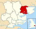 Colchester shown within Essex | |
| Sovereign state | United Kingdom |
| Constituent country | England |
| Region | East of England |
| Non-metropolitan county | Essex |
| Status | Non-metropolitan district, Borough |
| Admin HQ | Colchester |
| Incorporated | 1 April 1974 |
| Government | |
| • Type | Non-metropolitan district council |
| • Body | Colchester Borough Council |
| • Leadership | Leader & Cabinet (Liberal Democrat / Labour / Independent) |
| • MPs | Bernard Jenkin Priti Patel Will Quince |
| Area | |
| • Total | 128.64 sq mi (333.18 km2) |
| Area rank | 128th (of 317) |
| Population (mid-2019 est.) | |
| • Total | 194,706 |
| • Rank | 96th (of 317) |
| • Density | 1,500/sq mi (580/km2) |
| • Ethnicity | 92% White 3.6% Asian 1.4% Black 1.8% Mixed 1% Arab or Other |
| Time zone | UTC0 (GMT) |
| • Summer (DST) | UTC+1 (BST) |
| ONS code | 22UG (ONS) E07000071 (GSS) |
| OS grid reference | TL997254 |
| Website | www |
The borough was formed on 1 April 1974 by the merger of the former borough of Colchester, covering an area of around 17.7 square miles (46 km2),[1] with the urban districts of West Mersea and Wivenhoe, along with Lexden and Winstree Rural District.
Demography
The Essex County Standard of September 4, 2009 said that "Government estimates" made Colchester the largest borough in the county: its officially acknowledged population is second highest among non-London boroughs, behind Northampton.
According to the Office for National Statistics as of 2008, Colchester had a population of approximately 181,000.[2] Average life expectancy was 78.7 for males. and 83.3 for females.[3]
Based on ethnic groups, predominantly of 92% of the population is White (87.5% British, 0.7% Irish and 3.8% Other White), Asians were the second largest making up 3.6% (0.8% Indian, 0.2% Pakistani, 0.2% Bangladeshi and 1% Chinese, other 1.4%), Black people constituted 1.4% (0.3% Caribbean, 1% African, 0.1% other), those of mixed race made up 1.8%, 0.6% were Arab and there were 0.4% from other ethnic groups.[4]
In the 2011 census, 57.7% identified themselves as Christian, while 31.4% had no affiliation to a religion. Of other religions, 1.6% identified as Muslim, 0.7% Hindu, 0.6% Buddhist, 0.2% Jewish, 0.1% Sikh, 0.5% others, and 7.3% did not answer.[5] There are more than 100 churches located in Colchester: other religious places of worship include the Colchester Islamic Cultural Association and the Jewish Community Synagogue.
History
Colchester is the oldest recorded town in Britain, being founded by the Romans as their capital. Colchester was one of the three towns attacked by Boadicea. It is home to many historic buildings, including the Norman castle, built on the remains of a Roman temple; the Tudor town house, now Red Lion Inn, which was owned by the Howard family; a Saxon church and many more.
Governance
Elections to Colchester Borough Council are held in three out of every four years, with one third of the 51 seats on the council being elected at each election. Since the 1998 election no party has held a majority on the council apart from the period between 2007 and the 2008 election when the Conservative party had a majority. Since the 2008 election the council has been run by a coalition between the Liberal Democrats, Labour and independent groups and as of the 2019 election the council is composed of the following councillors:
| Party | Councillors | |
| Conservative Party | 23 | |
| Liberal Democrats | 13 | |
| Labour Party | 11 | |
| Independent | 3 | |
| Green Party | 1 | |
Places in Colchester District
- Abberton
- Aldham
- Birch
- Boxted
- Braiswick
- Chappel
- Colchester
- Copford
- Dedham
- Easthorpe
- Eight Ash Green
- Fingringhoe
- Fordham
- Great Horkesley
- Great Tey
- Great Wigborough
- Hythe
- Inworth
- Langham
- Langham Moor
- Layer Breton
- Layer de la Haye
- Layer Marney
- Lexden
- Little Horkesley
- Little Tey
- Little Wigborough
- Marks Tey
- Mersea Island
- Mount Bures
- Rowhedge
- Salcott
- Smythe's Green
- Stanway
- Tiptree
- Virley
- Wakes Colne
- West Bergholt
- Wivenhoe
See also
- List of Mayors of Colchester
References
- A P Baggs; Beryl Board; Philip Crummy; Claude Dove; Shirley Durgan; N R Goose; R B Pugh; Pamela Studd; C C Thornton (1994). Janet Cooper; C R Elrington (eds.). "The Borough of Colchester". A History of the County of Essex: Volume 9: The Borough of Colchester. Institute of Historical Research. Retrieved 29 June 2013.
- Colchester Resident Population ONS. Retrieved on 2010-03-07.
- Colchester Life Expectancy ONS. Retrieved on 2010-03-07.
- "Neighbourhood Statistics". Office for National Statistics (ONS). Retrieved 2012-12-22.
- "2011 Census: Religion, local authorities in England and Wales". Office for National Statistics (ONS). Retrieved 2012-12-22.
| Authority control |
|---|