Buschwiller
Buschwiller (German: Buschweiler) is a commune in the Haut-Rhin department in Alsace in north-eastern France.
Buschwiller | |
|---|---|
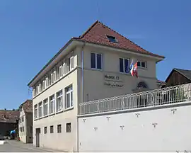 The town hall and school in Buschwiller | |
.svg.png.webp) Coat of arms | |
Location of Buschwiller 
| |
 Buschwiller  Buschwiller | |
| Coordinates: 47°33′33″N 7°30′29″E | |
| Country | France |
| Region | Grand Est |
| Department | Haut-Rhin |
| Arrondissement | Mulhouse |
| Canton | Saint-Louis |
| Government | |
| • Mayor (2008–2014) | Christèle Willer |
| Area 1 | 4.16 km2 (1.61 sq mi) |
| Population (2017-01-01)[1] | 1,040 |
| • Density | 250/km2 (650/sq mi) |
| Time zone | UTC+01:00 (CET) |
| • Summer (DST) | UTC+02:00 (CEST) |
| INSEE/Postal code | 68061 /68220 |
| Elevation | 282–372 m (925–1,220 ft) (avg. 315 m or 1,033 ft) |
| 1 French Land Register data, which excludes lakes, ponds, glaciers > 1 km2 (0.386 sq mi or 247 acres) and river estuaries. | |
See also
Geography and climate
Geography
Buschwiller is a village located in the french suburb of Basel. It is adjacent to the swiss town of Schönenbuch.
Climate
Due to its position, in the far north-east of France, Buschwiller features a semi-continental climate (Köppen : Cfb), characterized by warm to hot, humid summers and cool to cold, drier winters. It usually snows every year, but without substantial accumulation.
| Climate data for Basel (Binningen), elevation: 316 m (1,037 ft), 1981–2010 normals, extremes 1901–present | |||||||||||||
|---|---|---|---|---|---|---|---|---|---|---|---|---|---|
| Month | Jan | Feb | Mar | Apr | May | Jun | Jul | Aug | Sep | Oct | Nov | Dec | Year |
| Record high °C (°F) | 19.0 (66.2) |
22.0 (71.6) |
25.2 (77.4) |
30.5 (86.9) |
33.5 (92.3) |
38.4 (101.1) |
39.0 (102.2) |
38.7 (101.7) |
35.0 (95.0) |
29.6 (85.3) |
21.9 (71.4) |
20.6 (69.1) |
39.0 (102.2) |
| Average high °C (°F) | 4.5 (40.1) |
6.4 (43.5) |
11.2 (52.2) |
15.2 (59.4) |
19.6 (67.3) |
22.9 (73.2) |
25.3 (77.5) |
24.7 (76.5) |
20.3 (68.5) |
15.2 (59.4) |
8.7 (47.7) |
5.2 (41.4) |
14.9 (58.8) |
| Daily mean °C (°F) | 1.6 (34.9) |
2.7 (36.9) |
6.6 (43.9) |
10.0 (50.0) |
14.2 (57.6) |
17.4 (63.3) |
19.7 (67.5) |
19.1 (66.4) |
15.1 (59.2) |
10.9 (51.6) |
5.5 (41.9) |
2.6 (36.7) |
10.5 (50.9) |
| Average low °C (°F) | −1.1 (30.0) |
−0.5 (31.1) |
2.5 (36.5) |
5.1 (41.2) |
9.2 (48.6) |
12.4 (54.3) |
14.5 (58.1) |
14.2 (57.6) |
10.9 (51.6) |
7.4 (45.3) |
2.7 (36.9) |
0.1 (32.2) |
6.5 (43.7) |
| Record low °C (°F) | −24.2 (−11.6) |
−23.8 (−10.8) |
−14.8 (5.4) |
−6.3 (20.7) |
−2.7 (27.1) |
1.1 (34.0) |
5.1 (41.2) |
3.6 (38.5) |
−1.3 (29.7) |
−5.5 (22.1) |
−11.0 (12.2) |
−20.9 (−5.6) |
−24.2 (−11.6) |
| Average precipitation mm (inches) | 47 (1.9) |
45 (1.8) |
55 (2.2) |
64 (2.5) |
99 (3.9) |
86 (3.4) |
91 (3.6) |
80 (3.1) |
78 (3.1) |
73 (2.9) |
59 (2.3) |
66 (2.6) |
842 (33.1) |
| Average snowfall cm (inches) | 8.9 (3.5) |
11.5 (4.5) |
4.6 (1.8) |
0.7 (0.3) |
0.0 (0.0) |
0.0 (0.0) |
0.0 (0.0) |
0.0 (0.0) |
0.0 (0.0) |
0.1 (0.0) |
2.6 (1.0) |
8.5 (3.3) |
36.9 (14.5) |
| Average precipitation days (≥ 1.0 mm) | 9.3 | 8.4 | 9.8 | 10.2 | 12.4 | 10.9 | 10.2 | 9.9 | 8.8 | 10.1 | 10.0 | 10.4 | 120.4 |
| Average snowy days (≥ 1.0 cm) | 3.0 | 2.9 | 1.3 | 0.2 | 0.0 | 0.0 | 0.0 | 0.0 | 0.0 | 0.1 | 1.0 | 2.6 | 11.1 |
| Average relative humidity (%) | 81 | 76 | 70 | 68 | 72 | 71 | 70 | 72 | 77 | 81 | 82 | 82 | 75 |
| Mean monthly sunshine hours | 67 | 80 | 119 | 149 | 175 | 196 | 223 | 206 | 150 | 104 | 68 | 52 | 1,590 |
| Percent possible sunshine | 29 | 32 | 36 | 40 | 41 | 45 | 51 | 53 | 45 | 36 | 29 | 25 | 40 |
| Source 1: MeteoSwiss[2] | |||||||||||||
| Source 2: KNMI[3] | |||||||||||||
.
References
- "Populations légales 2017". INSEE. Retrieved 6 January 2020.
- "Climate Normals Basel Binningen (Reference period 1981−2010)" (PDF). Lugano, Switzerland: Swiss Federal Office of Metreology and Climatology, MeteoSwiss. 4 January 2017. Retrieved 12 February 2019.
- "Indices Data - Lugano (Station 239)". KNMI. Retrieved 12 February 2019.
| Wikimedia Commons has media related to Buschwiller. |
| Authority control |
|---|
This article is issued from Wikipedia. The text is licensed under Creative Commons - Attribution - Sharealike. Additional terms may apply for the media files.