Pfetterhouse
Pfetterhouse (Alemannic German: Pfatterhüse; German: Pfetterhausen) is a commune in the Haut-Rhin department in Alsace in north-eastern France.
Pfetterhouse
Pfatterhüse | |
|---|---|
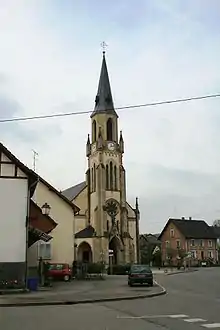 The church in Pfetterhouse | |
.svg.png.webp) Coat of arms | |
Location of Pfetterhouse 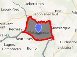
| |
 Pfetterhouse  Pfetterhouse | |
| Coordinates: 47°30′06″N 7°10′02″E | |
| Country | France |
| Region | Grand Est |
| Department | Haut-Rhin |
| Arrondissement | Altkirch |
| Canton | Masevaux |
| Government | |
| • Mayor (2020–2026) | Jean-Rodolphe Frisch[1] |
| Area 1 | 14.28 km2 (5.51 sq mi) |
| Population (2017-01-01)[2] | 980 |
| • Density | 69/km2 (180/sq mi) |
| Time zone | UTC+01:00 (CET) |
| • Summer (DST) | UTC+02:00 (CEST) |
| INSEE/Postal code | 68257 /68480 |
| Elevation | 391–501 m (1,283–1,644 ft) (avg. 481 m or 1,578 ft) |
| 1 French Land Register data, which excludes lakes, ponds, glaciers > 1 km2 (0.386 sq mi or 247 acres) and river estuaries. | |
Geography
Pfetterhouse is located in Jura Alsatian foothills, just in the border of Switzerland and Territoire de Belfort.
Origins of its name
The first mention of this village is dated from 732 AD and comes from Latin : Petrosa "the rocky one". An explanation of this origin could be the fact that rocks from Pfetterhouse's career were used to build a Roman station not far from Petrosa or the presence of a Roman paved road. It explains the use of the French variant form Pérouse. The Alemanic form is already mentioned as Phetterhusen in a 1296 document. The spelling ph in Old High German notes pf in Modern German.
From the 17th century to 1919, the German Pfetterhausen (-hausen is an often-used suffix for German village names) was used instead, then in 1919 Pérouse (which more sounds French, because Alsace was taken back by France) and, in the end, Pfetterhouse, -house is a widespread spelling in Alsace (see Mulhouse) for the Alemanic -hüse and the German -hausen
History
Before World War I, a big clock factory attracted several new citizens, but this factory didn't manage to recover after World War I and World War II, and finally closed just after World War II.
The Borne des Trois Puissances (Three Powers Boundary Stone) is situated in Pfetterhouse area. Until 1919, this stone was the point where the borders of France, Germany and Switzerland met. This boundary stone gave to the village an international renown: many people from France, Germany or Switzerland came to have their photograph taken with it, which they could send to relatives as a postal card.
A railway once passed through Pfetterhouse, but because of a lack of travellers and industry, it closed in the 1960s. The rail station was renovated for housing.
Demography
1962: 789
1968: 809
1975: 906
1982: 924
1990: 971
1999: 972
2006: 1050
See also
References
- "Répertoire national des élus: les maires". data.gouv.fr, Plateforme ouverte des données publiques françaises (in French). 2 December 2020. Retrieved 7 December 2020.
- "Populations légales 2017". INSEE. Retrieved 6 January 2020.
External links
| Wikimedia Commons has media related to Pfetterhouse. |
| Authority control |
|
|---|