Rixheim
Rixheim (French pronunciation: [ʁiksaim]; Alsatian: Rixe) is a commune in the Haut-Rhin department in Grand Est in northeastern France. It forms part of the Mulhouse Alsace Agglomération, the inter-communal local government body for the Mulhouse conurbation.[2]
Rixheim
Rixe | |
|---|---|
 The commandery in Rixheim | |
.svg.png.webp) Coat of arms | |
Location of Rixheim 
| |
 Rixheim  Rixheim | |
| Coordinates: 47°44′58″N 7°24′19″E | |
| Country | France |
| Region | Grand Est |
| Department | Haut-Rhin |
| Arrondissement | Mulhouse |
| Canton | Rixheim |
| Intercommunality | Mulhouse Alsace Agglomération |
| Government | |
| • Mayor (2020–2026) | Ludovic Haye |
| Area 1 | 19.53 km2 (7.54 sq mi) |
| Population | 13,902 |
| • Density | 710/km2 (1,800/sq mi) |
| Time zone | UTC+01:00 (CET) |
| • Summer (DST) | UTC+02:00 (CEST) |
| INSEE/Postal code | 68278 /68170 |
| Elevation | 232–366 m (761–1,201 ft) |
| 1 French Land Register data, which excludes lakes, ponds, glaciers > 1 km2 (0.386 sq mi or 247 acres) and river estuaries. | |
Geography
Rixheim lies 5 kilometers east from the city center of Mulhouse, at the crossroads of Strasbourg and Mulhouse (A35-A36 to Sausheim) and Habsheim to Ottmarsheim (ancient Roman roads), the municipality of Rixheim is located in a loop of the Rhine ditch on the borders of the Hardt forest, the Sundgauvian hills and the alluvial plain of the Jll. The altitudes vary between 365 meters (Zürenwald) and 232 meters (Pont du Bouc). Rixheim lies six Kilometer east of Mulhouse.
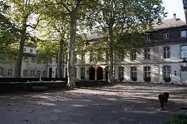
There was a commendam of the Teutonic Order, their buildings preserved to this day, were built by Johann Caspar Bagnato. It was under the command of the commendam Altshausen.
Neighbourship of Rixheim
The neighbourship of Rixheim, clockwise, start in the north:
| Illzach | Sausheim | Ottmarsheim | |
| Riedisheim |  |
Hombourg | |
| Bruebach | Habsheim, Zimmersheim |
Population
| Year | Pop. | ±% p.a. |
|---|---|---|
| 1968 | 5,723 | — |
| 1975 | 8,419 | +5.67% |
| 1982 | 10,718 | +3.51% |
| 1990 | 11,669 | +1.07% |
| 1999 | 12,608 | +0.86% |
| 2007 | 13,103 | +0.48% |
| 2012 | 13,632 | +0.79% |
| 2017 | 13,902 | +0.39% |
| Source: INSEE[3] | ||
Education
Rixheim has a public secondary school, the College Captain Dreyfus. It also has 4 elementary schools.
Twin towns
Notable places
- The former Commandery of the Teutonic Order
- The Saint-Léger church, with organ and the old presbytery
- Fountain of John of Nepomuk
- War memorial
- The museum of wallpaper
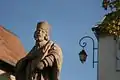 Fountain of John of Nepomuk
- The former Commandery
.jpg.webp) Entrance to the Park of the Commandery
Entrance to the Park of the Commandery Museum of wallpaper
 Saint-Léger church
 Rixheim Station
See also
References
- "Populations légales 2017". INSEE. Retrieved 6 January 2020.
- "Mulhouse Alsace Agglomération". Mulhouse Alsace Agglomération. Retrieved 2019-03-27.
- Population en historique depuis 1968, INSEE
External links
- Official website (in French)
| Wikimedia Commons has media related to Rixheim. |
| Authority control |
|
|---|