Husseren-les-Châteaux
Husseren-les-Châteaux (German: Häusern) is a commune in the Haut-Rhin department in Grand Est in north-eastern France. The village lies on the edge of the Ballons des Vosges Nature Park, where the Vosges meet the Upper Rhine Plain.
Husseren-les-Châteaux | |
|---|---|
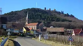 The road into Husseren-les-Châteaux | |
.svg.png.webp) Coat of arms | |
Location of Husseren-les-Châteaux 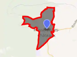
| |
 Husseren-les-Châteaux  Husseren-les-Châteaux | |
| Coordinates: 48°02′08″N 7°16′54″E | |
| Country | France |
| Region | Grand Est |
| Department | Haut-Rhin |
| Arrondissement | Colmar-Ribeauvillé |
| Canton | Wintzenheim |
| Government | |
| • Mayor (2008–2014) | Édouard Leiber |
| Area 1 | 1.2 km2 (0.5 sq mi) |
| Population (2017-01-01)[1] | 514 |
| • Density | 430/km2 (1,100/sq mi) |
| Time zone | UTC+01:00 (CET) |
| • Summer (DST) | UTC+02:00 (CEST) |
| INSEE/Postal code | 68150 /68420 |
| Elevation | 320–595 m (1,050–1,952 ft) (avg. 380 m or 1,250 ft) |
| 1 French Land Register data, which excludes lakes, ponds, glaciers > 1 km2 (0.386 sq mi or 247 acres) and river estuaries. | |
The village is overlooked by the ruins of three castles which stand in close proximity to each other: Dagsbourg, Wahlenbourg and Weckmund. They are known locally as Les Trois Chateaux. Although the ruins can be reached by car they are a popular hiking destination.
This village is one of the many villages along 'La Route des Vins d'Alsace', close to Eguisheim and is in the middle of vineyards. The village is connected to Eguisheim by the Route du Vin (D14).
See also
References
- "Populations légales 2017". INSEE. Retrieved 6 January 2020.
| Wikimedia Commons has media related to Husseren-les-Châteaux. |
| Authority control |
|---|
This article is issued from Wikipedia. The text is licensed under Creative Commons - Attribution - Sharealike. Additional terms may apply for the media files.