Steinbrunn-le-Bas
Steinbrunn-le-Bas (German: Niedersteinbrunn) is a commune in the urban area of Mulhouse located in north-eastern France.
Steinbrunn-le-Bas | |
|---|---|
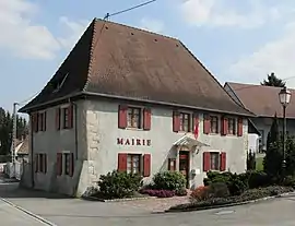 Town Hall | |
.svg.png.webp) Coat of arms | |
Location of Steinbrunn-le-Bas 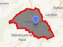
| |
 Steinbrunn-le-Bas  Steinbrunn-le-Bas | |
| Coordinates: 47°40′36″N 7°22′04″E | |
| Country | France |
| Region | Grand Est |
| Department | Haut-Rhin |
| Arrondissement | Mulhouse |
| Canton | Brunstatt |
| Intercommunality | CA Mulhouse Alsace Agglomération |
| Government | |
| • Mayor (2020–2026) | Daniel Hassler[1] |
| Area 1 | 8.58 km2 (3.31 sq mi) |
| Population (2017-01-01)[2] | 757 |
| • Density | 88/km2 (230/sq mi) |
| Time zone | UTC+01:00 (CET) |
| • Summer (DST) | UTC+02:00 (CEST) |
| INSEE/Postal code | 68323 /68440 |
| Elevation | 257–403 m (843–1,322 ft) (avg. 275 m or 902 ft) |
| 1 French Land Register data, which excludes lakes, ponds, glaciers > 1 km2 (0.386 sq mi or 247 acres) and river estuaries. | |
Its inhabitants are called Steinbrunnois and Steinbrunnoises.
Toponomy
- Steinebrun in 823
- Steinebronnen inferius, 1028
Etymologically, Steinbrunn means the source of the stone. The town owes its name to a nearby spring Taufsteinbrunn whose name is "the source of the baptismal font."
There was an old manor house, called Schlössel which had the right to tithes and a chapel known as the name Apollonia St., near which there was a source of water and where there are Roman brick remains. This chapel is dedicated to St. Appoline. One might assume that before the region was Christianised, the site was dedicated to Apollo. This town, once much larger, was, before the Reformation, divided into two parishes. The location of the church of Saint Léger is also known under the name of Kirchhof.
See also
References
- "Répertoire national des élus: les maires". data.gouv.fr, Plateforme ouverte des données publiques françaises (in French). 2 December 2020. Retrieved 7 December 2020.
- "Populations légales 2017". INSEE. Retrieved 6 January 2020.
| Wikimedia Commons has media related to Steinbrunn-le-Bas. |
| Authority control |
|
|---|
