Wettolsheim
Wettolsheim is a communes in the Haut-Rhin department in Grand Est in north-eastern France.
Wettolsheim | |
|---|---|
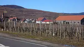 The road into Wettolsheim | |
.svg.png.webp) Coat of arms | |
Location of Wettolsheim 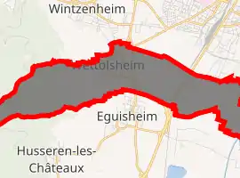
| |
 Wettolsheim  Wettolsheim | |
| Coordinates: 48°03′28″N 7°18′00″E | |
| Country | France |
| Region | Grand Est |
| Department | Haut-Rhin |
| Arrondissement | Colmar-Ribeauvillé |
| Canton | Wintzenheim |
| Intercommunality | Colmar Agglomération |
| Government | |
| • Mayor (2014-2020) | Lucien Muller |
| Area 1 | 8.86 km2 (3.42 sq mi) |
| Population (2017-01-01)[1] | 1,733 |
| • Density | 200/km2 (510/sq mi) |
| Time zone | UTC+01:00 (CET) |
| • Summer (DST) | UTC+02:00 (CEST) |
| INSEE/Postal code | 68365 /68920 |
| Elevation | 188–688 m (617–2,257 ft) (avg. 220 m or 720 ft) |
| 1 French Land Register data, which excludes lakes, ponds, glaciers > 1 km2 (0.386 sq mi or 247 acres) and river estuaries. | |
It is situated at the eastern margin of the southern Vosges Mountains. The commune is part of the Parc naturel régional des Ballons des Vosges.
Places of interest
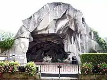
Grotte de Lourdes grandeur réelle: In 1912, after the destruction of the house of his birth by a fire, arch bishop François-Xavier Schoepfer (1843–1927), bishop of Tarbes and Lourdes from 1899 until 1927, decided to let build an exact copy of the grotto Massabielle in Lourdes at the same place where the house stood. The statue of the Virgin Mary was placed on a stone coming from the site where St. Bernadette Soubirous first saw the Immaculate Conception in 1858. The cavern in the heart of the village is still a place for a lot of religious ceremonies.
Population
| Year | Pop. | ±% |
|---|---|---|
| 2006 | 1,705 | — |
| 2007 | 1,701 | −0.2% |
| 2008 | 1,697 | −0.2% |
| 2009 | 1,693 | −0.2% |
| 2010 | 1,684 | −0.5% |
| 2011 | 1,675 | −0.5% |
| 2012 | 1,682 | +0.4% |
| 2013 | 1,688 | +0.4% |
| 2014 | 1,694 | +0.4% |
| 2015 | 1,703 | +0.5% |
| 2016 | 1,727 | +1.4% |
See also
References
- "Populations légales 2017". INSEE. Retrieved 6 January 2020.
| Wikimedia Commons has media related to Wettolsheim. |
| Authority control |
|
|---|