Chalampé
Chalampé (German: Eichwald) is a commune in the Haut-Rhin department in Alsace in north-eastern France, just across the Rhein River from Neuenburg, Germany.
Chalampé
Chalampé / Eichwald (arch.) | |
|---|---|
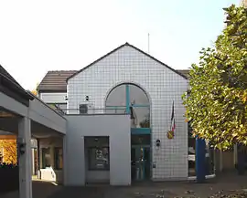 The town hall in Chalampé | |
.svg.png.webp) Coat of arms | |
Location of Chalampé 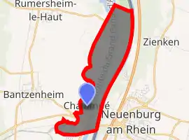
| |
 Chalampé  Chalampé | |
| Coordinates: 47°49′N 7°32′E | |
| Country | France |
| Region | Grand Est |
| Department | Haut-Rhin |
| Arrondissement | Mulhouse |
| Canton | Rixheim |
| Intercommunality | CA Mulhouse Alsace Agglomération |
| Government | |
| • Mayor (2020–2026) | Christine Dupont-Dufeutrelle |
| Area 1 | 4.77 km2 (1.84 sq mi) |
| Population (2017-01-01)[1] | 950 |
| • Density | 200/km2 (520/sq mi) |
| Time zone | UTC+01:00 (CET) |
| • Summer (DST) | UTC+02:00 (CEST) |
| INSEE/Postal code | 68064 /68490 |
| Dialling codes | 0389 |
| Elevation | 211–217 m (692–712 ft) (avg. 215 m or 705 ft) |
| 1 French Land Register data, which excludes lakes, ponds, glaciers > 1 km2 (0.386 sq mi or 247 acres) and river estuaries. | |
The town was founded by soldiers of Marshal Dubourg who in 1709 had beaten the Austrians under Count Claude Florimond de Mercy in the War of the Spanish Succession. It is located in an area called Eichwald (oak forest) by the otherwise German-speaking population of the Alsace, and bears its French name since 1735. Before Johann Gottfried Tulla and others straightened the Rhine in the 19th century, the river had changed its course several times, moving the border. Thus, the village was sometimes considered to be part of Germany.
See also
References
- "Populations légales 2017". INSEE. Retrieved 6 January 2020.
| Wikimedia Commons has media related to Chalampé. |
| Authority control |
|
|---|
This article is issued from Wikipedia. The text is licensed under Creative Commons - Attribution - Sharealike. Additional terms may apply for the media files.