Wattwiller
Wattwiller (Alemannic German: Wǎttwillr; German: Wattweiler) is a commune in the Haut-Rhin department of the Grand Est region, which lies in the north-eastern part of France.
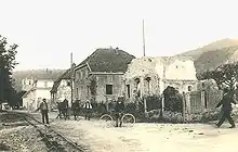
Wattwiller ruins in 1920
Wattwiller
Wǎttwillr | |
|---|---|
 A general view of Wattwiller | |
.svg.png.webp) Coat of arms | |
Location of Wattwiller 
| |
 Wattwiller  Wattwiller | |
| Coordinates: 47°50′13″N 7°10′51″E | |
| Country | France |
| Region | Grand Est |
| Department | Haut-Rhin |
| Arrondissement | Thann-Guebwiller |
| Canton | Cernay |
| Intercommunality | Thann-Cernay |
| Government | |
| • Mayor (2020–2026) | Mathieu Ermel |
| Area 1 | 13.61 km2 (5.25 sq mi) |
| Population (2017-01-01)[1] | 1,634 |
| • Density | 120/km2 (310/sq mi) |
| Time zone | UTC+01:00 (CET) |
| • Summer (DST) | UTC+02:00 (CEST) |
| INSEE/Postal code | 68359 /68700 |
| Elevation | 266–1,121 m (873–3,678 ft) (avg. 360 m or 1,180 ft) |
| 1 French Land Register data, which excludes lakes, ponds, glaciers > 1 km2 (0.386 sq mi or 247 acres) and river estuaries. | |
Located near the Vosges mountain rocky spur of Hartmannswillerkopf, Wattwiller was a strategic village in the Alsace, and suffered attacks in or near it during the Thirty Years' War and in both World Wars.
Nowadays Wattwiller is best known for its mineral water.
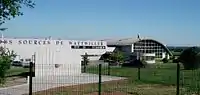 Mineral water plant
 Wattwiller mineral water
Population
| Year | Pop. | ±% |
|---|---|---|
| 2006 | 1,714 | — |
| 2007 | 1,721 | +0.4% |
| 2008 | 1,727 | +0.3% |
| 2009 | 1,734 | +0.4% |
| 2010 | 1,741 | +0.4% |
| 2011 | 1,738 | −0.2% |
| 2012 | 1,731 | −0.4% |
| 2013 | 1,706 | −1.4% |
| 2014 | 1,681 | −1.5% |
| 2015 | 1,656 | −1.5% |
| 2016 | 1,646 | −0.6% |
See also
References
- "Populations légales 2017". INSEE. Retrieved 6 January 2020.
| Wikimedia Commons has media related to Wattwiller. |
| Authority control |
|
|---|
This article is issued from Wikipedia. The text is licensed under Creative Commons - Attribution - Sharealike. Additional terms may apply for the media files.