Hégenheim
Hégenheim (French pronunciation: [eɡənaim]; German: Hegenheim; Alsatian: Hagena) is a commune in the Haut-Rhin department in Alsace in north-eastern France. It is adjacent to the Swiss town of Allschwil, and is part of the Basel urban area.
Hégenheim | |
|---|---|
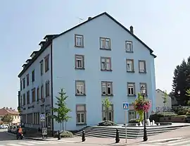 The town hall in Hégenheim | |
.svg.png.webp) Coat of arms | |
Location of Hégenheim 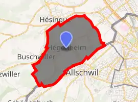
| |
 Hégenheim  Hégenheim | |
| Coordinates: 47°33′41″N 7°31′37″E | |
| Country | France |
| Region | Grand Est |
| Department | Haut-Rhin |
| Arrondissement | Mulhouse |
| Canton | Saint-Louis |
| Intercommunality | Trois Frontières |
| Government | |
| • Mayor (2008–2014) | Thomas Zeller |
| Area 1 | 6.7 km2 (2.6 sq mi) |
| Population (2017-01-01)[1] | 3,420 |
| • Density | 510/km2 (1,300/sq mi) |
| Time zone | UTC+01:00 (CET) |
| • Summer (DST) | UTC+02:00 (CEST) |
| INSEE/Postal code | 68126 /68220 |
| Elevation | 254–347 m (833–1,138 ft) (avg. 275 m or 902 ft) |
| 1 French Land Register data, which excludes lakes, ponds, glaciers > 1 km2 (0.386 sq mi or 247 acres) and river estuaries. | |
Geography
Hégenheim is a town in Grand Est region (or in Alsace), next to the Swiss border. Basel is the nearest major city, located 5 kilometers to the South-East. The nearest mountains are the Jura mountains, its foothills located 10 kilometers further South.
Climate
Under the Köppen climate classification, Hégenheim features an oceanic climate (Cfb), with strong warm-summer humid continental climate (Dfb) influences, due to its interior position within France. Winters are usually cold and moderately snowy, while summers are warm to hot, and potentially stormy.
| Climate data for Hégenheim, elevation: 316 m (1,037 ft) | |||||||||||||
|---|---|---|---|---|---|---|---|---|---|---|---|---|---|
| Month | Jan | Feb | Mar | Apr | May | Jun | Jul | Aug | Sep | Oct | Nov | Dec | Year |
| Record high °C (°F) | 16.6 (61.9) |
22.0 (71.6) |
25.6 (78.1) |
30.0 (86.0) |
33.2 (91.8) |
36.5 (97.7) |
37.7 (99.9) |
38.1 (100.6) |
33.5 (92.3) |
28.0 (82.4) |
22.5 (72.5) |
17.4 (63.3) |
38.1 (100.6) |
| Average high °C (°F) | 5.0 (41.0) |
7.0 (44.6) |
11.8 (53.2) |
16.2 (61.2) |
19.9 (67.8) |
23.8 (74.8) |
25.8 (78.4) |
25.3 (77.5) |
20.7 (69.3) |
15.4 (59.7) |
9.2 (48.6) |
5.6 (42.1) |
15.5 (59.9) |
| Daily mean °C (°F) | 2.4 (36.3) |
3.6 (38.5) |
7.3 (45.1) |
11.0 (51.8) |
14.8 (58.6) |
18.5 (65.3) |
20.5 (68.9) |
20.1 (68.2) |
16.0 (60.8) |
11.6 (52.9) |
6.4 (43.5) |
3.1 (37.6) |
11.3 (52.3) |
| Average low °C (°F) | −0.3 (31.5) |
0.1 (32.2) |
2.8 (37.0) |
5.7 (42.3) |
9.6 (49.3) |
13.2 (55.8) |
15.1 (59.2) |
14.9 (58.8) |
11.2 (52.2) |
7.8 (46.0) |
3.5 (38.3) |
0.6 (33.1) |
7.0 (44.6) |
| Record low °C (°F) | −24.1 (−11.4) |
−23.8 (−10.8) |
−14.8 (5.4) |
−6.3 (20.7) |
−2.7 (27.1) |
0.0 (32.0) |
5.1 (41.2) |
3.6 (38.5) |
−1.3 (29.7) |
−5.5 (22.1) |
−11.0 (12.2) |
−20.9 (−5.6) |
−24.1 (−11.4) |
| Average precipitation mm (inches) | 47.4 (1.87) |
45.0 (1.77) |
49.5 (1.95) |
62.8 (2.47) |
97.2 (3.83) |
85.4 (3.36) |
88.6 (3.49) |
88.1 (3.47) |
69.8 (2.75) |
74.2 (2.92) |
64.7 (2.55) |
64.6 (2.54) |
837.5 (32.97) |
| Mean monthly sunshine hours | 67.7 | 88.4 | 138.1 | 167.5 | 181.8 | 207.4 | 231.8 | 218.8 | 162.5 | 112.8 | 66.8 | 56.3 | 1,699.9 |
| Source: MeteoSwiss | |||||||||||||
References
- "Populations légales 2017". INSEE. Retrieved 6 January 2020.
External links
| Wikimedia Commons has media related to Hégenheim. |
- Official site
- Travel Index guide (in French)
| Authority control |
|
|---|
