Stockinbingal
Stockinbingal is a town in the South West Slopes and Riverina regions of New South Wales, Australia. The town is in the Cootamundra–Gundagai Regional Council local government area and on the Burley Griffin Way. At the 2016 census, Stockinbingal had a population of 374.[1]
| Stockinbingal New South Wales | |
|---|---|
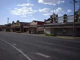 Main Street of Stockinbingal | |
Stockinbingal | |
| Coordinates | 34°30′0″S 147°53′0″E |
| Population | 374 (2016 census)[1] |
| Postcode(s) | 2725 |
| Elevation | 303 m (994 ft) |
| Location |
|
| LGA(s) | Gundagai Council |
| County | Bland |
| State electorate(s) | Cootamundra |
| Federal Division(s) | Hume |
Stockinbingal Post Office opened on 16 May 1891.[2]
Railways
It is the location of a railway junction connecting the Cootamundra to Lake Cargelligo railway line (completed to Stockinbingal in 1893) to Parkes, which provides an alternative route from Sydney to Parkes to the route over the Blue Mountains, avoiding that route's steep grades and is now as a result the major route for freight between Sydney and Perth. The route from Cootamundra to Stockinbingal and Parkes is also part of a rail bypass of Sydney for traffic between Melbourne and Brisbane via Dubbo, Werris Creek and Maitland.[3]
Stockinbingal is the closest town to the Yeo Yeo district, where the Bradman family had a farm and Don Bradman lived as a child. The shell of the old Yeo Yeo schoolhouse may be seen a few km from town on the road to Wallendbeen.
Gallery
 Commercial Hotel, Stockinbingal
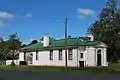 Former Bank of New South Wales
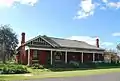 Former Stockinbingal Hotel
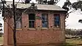 Old schoolhouse in Yeo Yeo district, now a farm outbuilding
References
- Australian Bureau of Statistics (27 June 2017). "Stockinbingal (L) (Urban Centre/Locality)". 2016 Census QuickStats. Retrieved 3 August 2019.

- Phoenix Auctions History, Post Office List, retrieved 3 February 2021
- NSWRail.Net
External links
![]() Media related to Stockinbingal at Wikimedia Commons
Media related to Stockinbingal at Wikimedia Commons