Leeton Shire
Leeton Shire is a local government area in the Riverina region of New South Wales, Australia. The Shire is located adjacent to the Murrumbidgee River and falls within the Murrumbidgee Irrigation Area.
| Leeton Shire New South Wales | |||||||||||||||
|---|---|---|---|---|---|---|---|---|---|---|---|---|---|---|---|
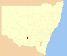 Location in New South Wales | |||||||||||||||
| Coordinates | 34°33′S 146°24′E | ||||||||||||||
| Population | |||||||||||||||
| • Density | 9.570/km2 (24.786/sq mi) | ||||||||||||||
| Established | 6 January 1928[3] | ||||||||||||||
| Area | 1,167 km2 (450.6 sq mi)[4] | ||||||||||||||
| Mayor | Paul Maytom[5] | ||||||||||||||
| Council seat | Leeton[6] | ||||||||||||||
| Region | Riverina | ||||||||||||||
| State electorate(s) | Murray | ||||||||||||||
| Federal Division(s) | Farrer[7] | ||||||||||||||
| Website | Leeton Shire | ||||||||||||||
| |||||||||||||||
The Shire includes the town of Leeton and the small towns of Yanco, Gogeldrie, Whitton, Wamoon, Stoney Point, Murrami, Corbie Hill, Amesbury, Merungle Hill, Fivebough and Stanbridge and the suburbs of Parkview, Wattle Hill, Wiradjuri, North Leeton, Gralee and Willimbong.
The shire was created on 6 January 1928 under the provisions of the Irrigation Act 1912 from land previously part of Yanko Shire and was originally called Willembong Shire.[3] It was renamed as Leeton Shire on 10 July 1946.[8]
The mayor of Leeton Shire is Paul Maytom.
Council
Current composition and election method
Leeton Shire Council is composed of nine councillors elected proportionally as a single ward. All Councillors are elected for a fixed four-year term of office. The mayor is elected by the councillors at the first meeting of the Council. The most recent election was held on 10 September 2016, and the makeup of the Council is as follows:[9]
| Party | Councillors | |
|---|---|---|
| Independents and Unaligned | 8 | |
| Vacant | 1 | |
| Total | 9 | |
The current Council, elected in 2016, in order of election, is:[9]
| Councillor | Party | Notes | |
|---|---|---|---|
| Paul Maytom | Independent | Mayor[10] | |
| George Weston | Independent | Deputy Mayor[10] | |
| Paul Smith | Unaligned | ||
| Tony Reneker | Unaligned | ||
| Tracey Morris | Independent | ||
| Michael Kidd | Unaligned | ||
| Tony Ciccia | Independent | ||
| Sandra Nardi | Independent | ||
| Peter Davidson | Independent | ||
Heritage listings
Leeton Shire has a number of heritage-listed sites, including:
References
- Australian Bureau of Statistics (27 June 2017). "Leeton (A) (Local Government Area)". 2016 Census QuickStats. Retrieved 27 June 2017.

- "3218.0 – Regional Population Growth, Australia, 2017-18". Australian Bureau of Statistics. 27 March 2019. Retrieved 27 March 2019. Estimated resident population (ERP) at 30 June 2018.
- "Irrigation Act 1912-1926. Proclamation (2)". Government Gazette of the State of New South Wales. 6 January 1928. p. 42. Retrieved 24 December 2019 – via National Library of Australia.
- "Leeton Regional Profile". Riverina Regional Development Board. Retrieved 28 August 2008.
- Gray, John (20 September 2012). "Council's top pair return unopposed". The Irrigator. Retrieved 3 October 2012.
- "Leeton Shire Council". Department of Local Government. Retrieved 8 November 2006.
- "Profile of the electoral division of Farrer (NSW)". Australian Electoral Commission. 25 February 2016. Retrieved 12 July 2016.
- "Local Government Act 1919. Proclamation (78)". Government Gazette of the State of New South Wales. 19 July 1946. p. 1597. Retrieved 24 December 2019 – via National Library of Australia.
- "Leeton Shire Council: Summary of First Preference and Group Votes for each Candidate". Local Government Elections 2016. Electoral Commission of New South Wales. 20 September 2016. Retrieved 5 November 2016.
- "Leeton Shire Council - Elected Councillors". www.leeton.nsw.gov.au. Retrieved 5 November 2016.
- "Gogeldrie Weir". New South Wales State Heritage Register. Office of Environment and Heritage. H00961. Retrieved 18 May 2018.
- "Hydro Hotel". New South Wales State Heritage Register. Office of Environment and Heritage. H00247. Retrieved 18 May 2018.
- "Koonadan". Office of Environment and Heritage. Retrieved 4 June 2019.
- "Leeton District Lands Office". New South Wales State Heritage Register. Office of Environment and Heritage. H00965. Retrieved 18 May 2018.
- "Leeton District Office - Artefacts in Reception Lobby Showcase 1". New South Wales State Heritage Register. Office of Environment and Heritage. H00966. Retrieved 18 May 2018.
- "Leeton Railway Station and yard group". New South Wales State Heritage Register. Office of Environment and Heritage. H01178. Retrieved 18 May 2018.
- "Roxy Community Theatre". New South Wales State Heritage Register. Office of Environment and Heritage. H01747. Retrieved 18 May 2018.
- "Yanco Weir and site". New South Wales State Heritage Register. Office of Environment and Heritage. H00969. Retrieved 18 May 2018.