Coolac, New South Wales
Coolac is a village in the Riverina region of New South Wales, Australia in Gundagai Council. At the 2016 census, Coolac had a population of 216.[1]
| Coolac New South Wales | |||||||||
|---|---|---|---|---|---|---|---|---|---|
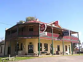 Coolac Hotel | |||||||||
Coolac | |||||||||
| Coordinates | 34°55′0″S 148°09′0″E | ||||||||
| Population | 216 (2016 census)[1] | ||||||||
| Established | 1824 | ||||||||
| Postcode(s) | 2727 | ||||||||
| Elevation | 308 m (1,010 ft) | ||||||||
| Location |
| ||||||||
| LGA(s) | Gundagai Council | ||||||||
| County | Harden | ||||||||
| State electorate(s) | Cootamundra | ||||||||
| Federal Division(s) | Riverina | ||||||||
| |||||||||
History
The place name Coolac is derived from the local Aboriginal name for a plant which was abundant in the area and also from the Aboriginal word meaning "native bear".[4]
Coolac Post Office opened on 1 June 1870.[5]
The 11 kilometre section of the Hume Highway at Coolac was the last two-lane section of highway between Sydney and the Sturt Highway interchange. Since 1986, plans had been drawn-up for the Coolac bypass, with a review of environmental factors report completed in 1997 but construction did not commence until May 2007 with the project opening in August 2009 - Under AusLink.[6][7][8][9][10][11]
In August 2009, the Coolac bypass was officially opened.[12]
Bald Archy
The satirical Bald Archy art competition (named from the more prestigious Archibald Prize) began in Coolac at the Coolac Festival of Fun, launched by Peter Batey. The home of this competition is now the Museum of the Riverina in Wagga Wagga and it also travels to Sydney and Melbourne for exhibition once Maude the Cockatoo, who is the official judge, selects the winning entries each year.
Coolac Geological Site
The Coolac Geological Site 48 kilometres (30 mi) north-east of Coolac, is the best known example in Australia of a substantial ophiolite assemblage. The distinctive rock assemblage over a 130-hectare (320-acre) site provides insights into events in the continental evolution of eastern Australia.[13][14] The rocks here were part of the oceanic crust and mantle, normally not exposed on the Earth's surface. The rock from the mantle is called Coolac Serpentinite.
References
- Australian Bureau of Statistics (27 June 2017). "Coolac (State Suburb)". 2016 Census QuickStats. Retrieved 1 April 2018.

- "Gundagai to Coolac". Google Maps.
- "Summary statistics Gundagai (William Str)". Bureau of Meteorology. Commonwealth of Australia. 2 June 2011. Retrieved 5 June 2011.
- "Coolac". Geographical Names Register (GNR) of NSW. Geographical Names Board of New South Wales.
- Premier Postal History. "Post Office List". Retrieved 11 June 2009.
- $179 million Coolac Bypass officially opens Archived 2011-02-22 at the Wayback Machine
- ABC Riverina NSW 2009 finish date for Hume Highway work
- Work begins on bypassing Hume Hwy black spot
- AbiGroup - Coolac Bypass, NSW
- Coolac bypass construction officially begins Quote: "Mrs Hull said the project has been fully funded by the Australian Government at a cost of $179 million and the 12 kilometre bypass and four-kilometre highway upgrade is due to be open in November 2009. "
- Gundagai bridge to open this month: RTA
- "Coolac Bypass". Roads and Traffic Authority. Archived from the original on 18 September 2009. Retrieved 25 August 2009.
- Australian Government Department Transport and Regional Services, Segment 1.4 Wagga to Yass Archived 2006-09-03 at the Wayback Machine
- for example, abstract of article in GeoScience World Tectonic significance of 400 Ma zircon ages for ophiolitic rocks from the Lachlan fold belt, eastern Australia and an article in the Journal and Proceedings of the Royal Society of New South Wales entitled Hydrothermal Ca-Al Silicates in Ophiolitic Rocks near Coolac, N.S.W. Archived 2006-11-04 at the Wayback Machine
External links
![]() Media related to Coolac, New South Wales at Wikimedia Commons
Media related to Coolac, New South Wales at Wikimedia Commons