Berrigan Shire
Berrigan Shire is a local government area in the southern Riverina region of New South Wales, Australia. The Shire lies on the New South Wales State border with Victoria formed by the Murray River. The Shire is adjacent to the Newell and Riverina Highways. The Shire is a mainly agricultural region, with dairying, cattle raising, woolgrowing and cropping the main activities. The vast majority of the Shire is irrigated. Tourism is another major activity, concentrated on the river towns of Tocumwal and Barooga.
| Berrigan Shire New South Wales | |||||||||||||||
|---|---|---|---|---|---|---|---|---|---|---|---|---|---|---|---|
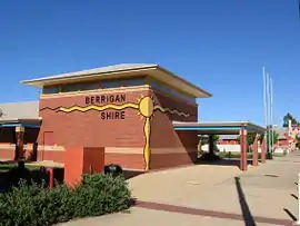 Berrigan Shire Office, Chanter Street, Berrigan. | |||||||||||||||
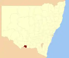 Location of Berrigan Shire, on map of New South Wales. | |||||||||||||||
| Coordinates | 35°38′S 145°48′E | ||||||||||||||
| Population |
| ||||||||||||||
| • Density | 4.0958/km2 (10.608/sq mi) | ||||||||||||||
| Established | 1906 | ||||||||||||||
| Area | 2,066 km2 (797.7 sq mi) | ||||||||||||||
| Mayor | Cr. Matt Hannan (Unaligned)[3] | ||||||||||||||
| Council seat | Berrigan | ||||||||||||||
| Region | Riverina | ||||||||||||||
| State electorate(s) | Murray | ||||||||||||||
| Federal Division(s) | Farrer | ||||||||||||||
| Website | Berrigan Shire | ||||||||||||||
| |||||||||||||||
The mayor of Berrigan Shire is Cr. Matt Hannan, an unaligned politician.[3]
Towns and localities
Towns in the shire are:
Demographics
| Selected historical census data for Berrigan Shire local government area | ||||||
|---|---|---|---|---|---|---|
| Census year | 2011[4] | 2016[1] | ||||
| Population | Estimated residents on census night | 8,066 | ||||
| LGA rank in terms of size within New South Wales | 97th | |||||
| % of New South Wales population | ||||||
| % of Australian population | ||||||
| Cultural and language diversity | ||||||
| Ancestry, top responses | English | |||||
| Australian | ||||||
| Italian | ||||||
| Chinese | ||||||
| Irish | ||||||
| Language, top responses (other than English) | Italian | |||||
| Mandarin | ||||||
| Cantonese | ||||||
| Korean | ||||||
| Greek | ||||||
| Religious affiliation | ||||||
| Religious affiliation, top responses | Catholic | |||||
| No religion | ||||||
| Anglican | ||||||
| Eastern Orthodox | ||||||
| Buddhism | ||||||
| Median weekly incomes | ||||||
| Personal income | Median weekly personal income | A$ | ||||
| % of Australian median income | ||||||
| Family income | Median weekly family income | |||||
| % of Australian median income | ||||||
| Household income | Median weekly household income | |||||
| % of Australian median income | ||||||
Proposed amalgamation
A 2015 review of local government boundaries by the NSW Government Independent Pricing and Regulatory Tribunal recommended that the Berrigan Council merge with parts of the Jerilderie Shire to form a new council with an area of 4,022 square kilometres (1,553 sq mi) and support a population of approximately 10,000.[5] The Jerilderie Shire Council submitted an alternate proposal to the Minister for Local Government that the entire Jerilderie Shire amalgamate with the Murrumbidgee Shire.[6]
The NSW Government decided in May 2016 not to proceed with the proposed amalgamation.
Council
Current composition and election method
Berrigan Shire Council is composed of eight councillors elected proportionally as a single ward. All councillors are elected for a fixed four-year term of office. The mayor is elected by the councillors at the first meeting of the Council. The most recent election was held on 10 September 2016, and the makeup of the council is as follows:[7] A by-election was held in July 2018 to fill the spot left vacant by the death of Berrigan candidate Bernard Curtin.
| Party | Councillors | |
|---|---|---|
| Independents and Unaligned | 8 | |
| Total | 8 | |
The current Council, elected in 2016, with a by-election in June 2018, in order of election, is:[7]
| Councillor | Party | Notes | |
|---|---|---|---|
| John Bruce | Unaligned | ||
| Colin Jones | Unaligned | ||
| Matt Hannan | Unaligned | Mayor[3] | |
| Daryll Morris | Unaligned | Deputy Mayor[3] | |
| Denis Glanville | Unaligned | ||
| John Taylor | Unaligned | ||
| Ross Bodey | Unaligned | ||
| Roger Reynoldson | Unaligned | ||
References
- Australian Bureau of Statistics (27 June 2017). "Berrigan (A)". 2016 Census QuickStats. Retrieved 7 July 2017.

- "3218.0 – Regional Population Growth, Australia, 2017-18". Australian Bureau of Statistics. 27 March 2019. Retrieved 27 March 2019. Estimated resident population (ERP) at 30 June 2018.
- Bunn, Anthony (22 September 2016). "Berrigan Shire's youngest councillor has become mayor after its oldest decided to step aside". Border Mail. Fairfax. Retrieved 23 September 2016.
- Australian Bureau of Statistics (31 October 2012). "Berrigan (A)". 2011 Census QuickStats. Retrieved 7 July 2017.
- "Merger proposal: Berrigan Shire Council, Jerilderie Shire Council (part)" (PDF). Government of New South Wales. January 2016. p. 8. Retrieved 13 March 2016.
- Jerilderie Shire Council (26 January 2016). "Merger proposal: Jerilderie Shire Council and Murrumbidgee Shire Council" (PDF). Council Boundary Review. Government of New South Wales. Retrieved 13 March 2016.
- "Berrigan Shire Council - Candidates in Sequence of Election". Local Council Elections 2016. NSW Electoral Commission. 15 September 2016. Retrieved 23 September 2016..