The Rock, New South Wales
The Rock is a town with a population of 1,236,[1] in the Riverina region of southern New South Wales, Australia, in Lockhart Shire. It is 32 kilometres (20 mi) south-west of Wagga Wagga on the Olympic Highway.
| The Rock New South Wales | |
|---|---|
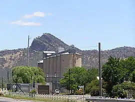 View across the rail lines and silos to The Rock Hill | |
The Rock | |
| Coordinates | 35°16′0″S 147°06′0″E |
| Population | 1,236 (2016 census)[1] |
| Postcode(s) | 2655 |
| Elevation | 236 m (774 ft) |
| Location | 32 km (20 mi) from Wagga Wagga |
| LGA(s) | Lockhart Shire |
| County | Mitchell |
| State electorate(s) | Wagga Wagga |
| Federal Division(s) | Farrer |
The town is named after the large rocky hill overlooking the town, now called The Rock Hill[2] but called Yerong in the local indigenous language. The reserve that includes The Rock Hill is an attraction in the area for bush-walking, rock-climbing, and observation of wildlife. It is also an Aboriginal sacred site, called Kengal.[3]
History
The Rock Post Office opened on 1 September 1890.[4]
Heritage listings
The Rock has a number of heritage-listed sites, including:
- Main Southern railway: The Rock railway station[5]
Transport
It is a railway junction town, being the junction point of the Boree Creek line from the Main South line. The Rock railway station is served by the twice daily NSW TrainLink XPT service to Melbourne and Sydney.
References
- Australian Bureau of Statistics (27 June 2017). "The Rock". 2016 Census QuickStats. Retrieved 26 August 2019.

- See www.exploroz.com, The Rock Hill – NSW; and Riverina Tourism, Lockhart surrounding towns and villages; both consulted on 20 December 2012.
- Environment and Heritage New South Wales, The Rock Nature Reserve (Kengal).
- Premier Postal History, Post Office List, retrieved 11 June 2009
- "The Rock Station and yard group". New South Wales State Heritage Register. Office of Environment and Heritage. H01268. Retrieved 18 May 2018.
| Wikimedia Commons has media related to The Rock, New South Wales. |