Kywong, New South Wales
Kywong is a rural locality in the Riverina region of New South Wales, Australia. The locality is situated on the Sturt Highway, 520 kilometres south west of the state capital, Sydney and 64 kilometres west of Wagga Wagga.
| Kywong New South Wales | |
|---|---|
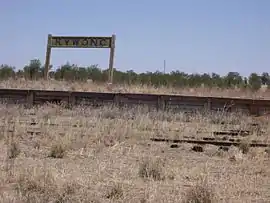 Kywong Railway Siding - closed 1975 | |
Kywong | |
| Coordinates | 34°59′0″S 146°44′0″E |
| Postcode(s) | 2700 |
| Location |
|
| LGA(s) | Narrandera Shire |
| County | Mitchell |
| State electorate(s) | Cootamundra |
| Federal Division(s) | Riverina |
Kywong was the terminus of a branch line of the Main Southern railway line, opened in 1929 and closed in 1975.[1] Shortly after, the Government Grain Elevators, later known as the Australian Wheat Board (AWB), constructed silos at Kywong for the storage of grain prior to rail transport to markets. The Kywong Public School opened in 1940 and closed in 1985. In 2001, the owners of the Kywong silos, GrainCorp announced their closure.[2]
References
| Wikimedia Commons has media related to Kywong, New South Wales. |
- "Kywong Branch". www.nswrail.net. Retrieved 2 February 2007.
- Tompson, Clem. "Kywong". Archived from the original on 27 February 2007. Retrieved 2 February 2007.
This article is issued from Wikipedia. The text is licensed under Creative Commons - Attribution - Sharealike. Additional terms may apply for the media files.