Junee Shire
The Junee Shire is a local government area in the Riverina region of New South Wales, Australia. The Shire comprises an area of 2,030 square kilometres (780 sq mi) and is located adjacent to the Olympic Highway and the Main South railway line. It was formed on 1 January 1981 from the amalgamation of the Municipality of Junee and Illabo Shire resulting from the Local Government Areas Amalgamation Act 1980.[3]
| Junee Shire New South Wales | |||||||||||||||
|---|---|---|---|---|---|---|---|---|---|---|---|---|---|---|---|
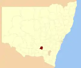 Location in New South Wales | |||||||||||||||
| Coordinates | 34°52′S 147°34′E | ||||||||||||||
| Population | |||||||||||||||
| • Density | 3.101/km2 (8.032/sq mi) | ||||||||||||||
| Established | 1 January 1981[3] | ||||||||||||||
| Area | 2,030 km2 (783.8 sq mi) | ||||||||||||||
| Mayor | Cr. Neil Smith (Unaligned)[4] | ||||||||||||||
| Council seat | Junee[5] | ||||||||||||||
| Region | Riverina | ||||||||||||||
| State electorate(s) | Cootamundra | ||||||||||||||
| Federal Division(s) | Riverina | ||||||||||||||
| Website | Junee Shire | ||||||||||||||
| |||||||||||||||
The Shire includes the town of Junee and the small towns of Bethungra, Illabo, Wantabadgery, Harefield, Old Junee, Junee Reefs, Dirnaseer and Eurongilly.
The mayor of Junee Shire is Cr. Neil Smith, an unaligned politician.[4]
Council
Current composition and election method
Junee Shire Council is composed of nine councillors elected proportionally as a single ward. All councillors are elected for a fixed four-year term of office. The mayor is elected by the councillors each September. The most recent council election was held on 10 September 2016, and the makeup of the Council is as follows:[6]
| Party | Councillors | |
|---|---|---|
| Independents and Unaligned | 9 | |
| Total | 9 | |
The current Council, elected in 2016, in order of election, is:[6]
| Councillor | Party | Notes | |
|---|---|---|---|
| Neil Smith | Independent | Mayor[4] | |
| Pam Halliburton | Unaligned | ||
| Matt Austin | Unaligned | Deputy Mayor[4] | |
| Robin Asmus | Independent | ||
| Kerri Walker | Unaligned | ||
| David Carter | Unaligned | ||
| Mark Cook | Independent | ||
| Bob Callow | Independent | ||
| Martin Holmes | Independent | ||
Gallery
 Former Illabo Shire Offices
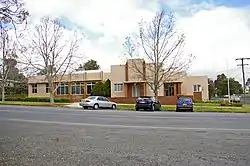
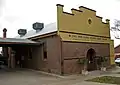 Regional Library
 Fire station, Council Emergency Control Centre and NSW State Emergency Service
References
- Australian Bureau of Statistics (27 June 2017). "Junee (A) (Local Government Area)". 2016 Census QuickStats. Retrieved 27 June 2017.

- "3218.0 – Regional Population Growth, Australia, 2017-18". Australian Bureau of Statistics. 27 March 2019. Retrieved 27 March 2019. Estimated resident population (ERP) at 30 June 2018.
- Local Government Areas Amalgamation Act 1980 (NSW) Schedule 1.
- "Your Councillors & Your Staff". Your council. Junee Shire Council. Archived from the original on 10 June 2014. Retrieved 21 October 2016.
- "Junee Shire Council". Department of Local Government. Archived from the original on 7 September 2006. Retrieved 7 November 2006.
- "Junee Shire Council: Summary of First Preference and Group Votes for each Candidate". Local Government Elections 2016. Electoral Commission of New South Wales. 17 September 2016. Retrieved 21 October 2016.