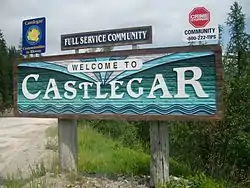
Castlegar, British Columbia
Castlegar is the second largest community in the West Kootenay region of British Columbia, Canada.
Castlegar | |
|---|---|
| City of Castlegar | |
 | |
| Motto(s): | |
 Castlegar Location of Castlegar in British Columbia | |
| Coordinates: 49°19′32″N 117°39′58″W | |
| Country | |
| Province | |
| Region | West Kootenay |
| Regional district | Central Kootenay |
| Incorporated | 1946 |
| Government | |
| • Type | Elected city council |
| • Mayor | Bruno Tassone |
| • Governing body | Castlegar City Council |
| • MP | Richard Cannings (NDP) |
| • MLA | Katrine Conroy (BC NDP) |
| Area | |
| • Total | 19.58 km2 (7.56 sq mi) |
| Elevation | 450 m (1,480 ft) |
| Population (2016) | |
| • Total | 8,039 |
| • Density | 408.6/km2 (1,058/sq mi) |
| Time zone | UTC−08:00 (PST) |
| Forward sortation area | V1N |
| Area code(s) | 250 / 778 / 236 |
| Highways | |
| Waterways | Columbia River Kootenay River |
| Website | City of Castlegar |
Castlegar is located within the Selkirk Mountains at the confluence of the Kootenay and Columbia Rivers. Castlegar is a regional trade and transportation centre, with a local economy fuelled by forestry, mining and tourism.
Castlegar was recently cited as one of the Top 8 Places in British Columbia for most promising growth.[2] It is home to Selkirk College, a regional airport, a pulp mill, and several sawmills. The population of 7,259 people includes many Doukhobors, who were largely responsible for much of Castlegar's early development and growth.
The area which was to become Castlegar was an important centre for the Sinixt (Lakes) Peoples. Outside the city limits are the small surrounding communities of Ootischenia, Brilliant, Robson, Robson West, Raspberry, Tarrys, Thrums, Glade,[3] Shoreacres, Fairview, Genelle, Pass Creek and Krestova. There are also the much smaller communities of Deer Park, Renata, and Syringa on Lower Arrow Lake.
Taken together, these outlying areas comprise an approximate population of a further 8,000 people.
History
On 5 September 1811, David Thompson arrived at the location where Castlegar now sits, where he camped near the mouth of the Kootenay River. A plaque dedicated to David Thompson can be found on the east bank of the Columbia River overlooking the present day site of Castlegar.
The first settlement in the area was West Waterloo, now known as South Castlegar. There was widespread provincial interest in gold prospecting in the late 19th century, and by 1895 there were forty houses in Waterloo. The town boomed until the end of the century when interest in the local mines declined.
Castlegar takes its name from Castlegar, County Galway in Ireland, the ancestral home of townsite founder Edward Mahon. (Castlegar is on the eastern boundary of the city of Galway.) The city was planned in 1897.[4] Around 1902, the Canadian Pacific Railway (CPR) built the bridge at Castlegar[5] and laid the wide gauge railway tracks to Trail. They put in a box car station at the old Waterloo trail crossing and called it Kinnaird Station in honour of Lord Kinnaird who was a shareholder in the CPR.[6]
There was little in Castlegar until after the completion of the CPR bridge. A Mr. Farmer built the first store in town, housing both the post office and the town hall. William Gage built the Castlegar Hotel in 1908, standing until 1982 when it was destroyed by fire. Also in 1908, the first schoolhouse was built by a few local residents who bought the lumber and erected the building. A dance pavilion, garage, tourist cabins and a slaughterhouse had all been established by 1925.
On 30 October 1946, Castlegar was incorporated into a village, then in 1966 into a town. It amalgamated with the neighbouring town of Kinnaird into a city on 1 January 1974, effectively doubling the population. On 20 May 2004, the City's boundary was extended to include the Blueberry Creek Irrigation District.
Indigenous peoples history
Castlegar is located in the border area between the Sinixt (Interior Salish) and the Ktunaxa Indian bands. Experts cannot agree where the Ktunaxa range ended, and where the Sinixt began. There was much overlapping of cultural and territorial activity between the two peoples. Most recent information suggests that the Sinixt were the original people in the area, and that the Kootenai arrived several hundred years ago from central Canada.
"Kp'itl'els", was a site on the north side of the Kootenay River, just above the junction with the Columbia River. Native implements (arrowheads, pestles, etc.) have been found along the nearby Arrow Lakes. A reconstructed kekuli dwelling was formally located on Zuckerberg Island, at the confluence of the Kootenay and Columbia rivers.
Doukhobor history
The Doukhobors put a ferry into operation near Brilliant on the Kootenay River in 1910 and the Christian Community of Universal Brotherhood (CCUB) made an application to the CPR for a railway station and siding to this point. Brilliant was the centre of the CCUB commercial enterprises. Located on the site was the Brilliant Jam Factory, a grain elevator, and a flax seed mill.
Demographics
- Population (2016): 9,023[7]
- Population (2011): 7,816
- Population (2006): 7,259
- Growth Rate: +7.7%
- Total Private Dwellings: 3,349
- Population Density: 399.3 per km²
- Area: 19.8 km²
- Median Age: 46.1
- Mother Tongue:
- English: 6,500
- French: 65
- Other: 1,010
- Number of Immigrants: 725
| Canada 2016 Census | Population | % of Total Population | |
|---|---|---|---|
| Visible minority group Source:[8] | South Asian | 215 | 2.8% |
| Chinese | 80 | 1% | |
| Black | 75 | 1% | |
| Filipino | 25 | 0.3% | |
| Latin American | 25 | 0.3% | |
| Arab | 0 | 0% | |
| Southeast Asian | 25 | 0.3% | |
| West Asian | 0 | 0% | |
| Korean | 0 | 0% | |
| Japanese | 20 | 0.3% | |
| Other visible minority | 0 | 0% | |
| Mixed visible minority | 20 | 0.3% | |
| Total visible minority population | 480 | 6.2% | |
| Aboriginal group Source:[9] | First Nations | 155 | 2% |
| Métis | 240 | 3.1% | |
| Inuit | 10 | 0.1% | |
| Total Aboriginal population | 415 | 5.3% | |
| White | 6,885 | 88.5% | |
| Total population | 7,780 | 100% | |
Climate
Castlegar has a humid continental climate (Köppen Dfb) or an inland oceanic climate (Cfb), bordering an inland warm-summer mediterranean climate (Köppen Csb). Summers are warm and sunny, with late summer being quite dry, while winters are cool and frequently unsettled. Precipitation peaks in the winter months when the Aleutian Low is strongest, and a range of precipitation is experienced, sometimes in short time periods. Castlegar is wetter than most places in the Southern Interior of BC, and the city receives around 400 mm more precipitation than nearby Kelowna, Penticton and Kamloops (which are in the drier Okanagan region of British Columbia, while Castlegar is in the Kootenay region).
The highest temperature ever recorded in Castlegar was 41.1 °C (106 °F) on 2 July 1924 and 11 July 1926.[10][11] The coldest temperature ever recorded was −30.6 °C (−23 °F) on 30 December 1968.[12]
| Climate data for West Kootenay Regional Airport, 1981–2010 normals, extremes 1916–present[lower-alpha 1] | |||||||||||||
|---|---|---|---|---|---|---|---|---|---|---|---|---|---|
| Month | Jan | Feb | Mar | Apr | May | Jun | Jul | Aug | Sep | Oct | Nov | Dec | Year |
| Record high °C (°F) | 10.0 (50.0) |
14.3 (57.7) |
23.1 (73.6) |
32.2 (90.0) |
34.5 (94.1) |
39.7 (103.5) |
41.1 (106.0) |
40.0 (104.0) |
36.8 (98.2) |
27.2 (81.0) |
19.4 (66.9) |
11.7 (53.1) |
41.1 (106.0) |
| Average high °C (°F) | 0.5 (32.9) |
3.2 (37.8) |
9.4 (48.9) |
15.3 (59.5) |
20.0 (68.0) |
23.6 (74.5) |
28.1 (82.6) |
28.2 (82.8) |
22.0 (71.6) |
12.9 (55.2) |
4.7 (40.5) |
0.0 (32.0) |
14.0 (57.2) |
| Daily mean °C (°F) | −1.6 (29.1) |
−0.1 (31.8) |
4.4 (39.9) |
8.8 (47.8) |
13.3 (55.9) |
16.8 (62.2) |
20.2 (68.4) |
20.0 (68.0) |
14.7 (58.5) |
8.0 (46.4) |
2.1 (35.8) |
−2.1 (28.2) |
8.7 (47.7) |
| Average low °C (°F) | −3.7 (25.3) |
−3.5 (25.7) |
−0.7 (30.7) |
2.3 (36.1) |
6.5 (43.7) |
10.0 (50.0) |
12.2 (54.0) |
11.7 (53.1) |
7.3 (45.1) |
3.0 (37.4) |
−0.6 (30.9) |
−4.2 (24.4) |
3.4 (38.1) |
| Record low °C (°F) | −25.7 (−14.3) |
−25.0 (−13.0) |
−18.3 (−0.9) |
−10.0 (14.0) |
−3.9 (25.0) |
−1.1 (30.0) |
3.3 (37.9) |
0.0 (32.0) |
−7.8 (18.0) |
−11.3 (11.7) |
−20.2 (−4.4) |
−30.6 (−23.1) |
−30.6 (−23.1) |
| Average precipitation mm (inches) | 75.5 (2.97) |
51.2 (2.02) |
62.9 (2.48) |
59.3 (2.33) |
70.3 (2.77) |
72.3 (2.85) |
48.1 (1.89) |
30.4 (1.20) |
42.4 (1.67) |
51.3 (2.02) |
96.7 (3.81) |
90.3 (3.56) |
750.9 (29.56) |
| Average rainfall mm (inches) | 26.2 (1.03) |
28.1 (1.11) |
50.1 (1.97) |
57.1 (2.25) |
70.1 (2.76) |
72.3 (2.85) |
48.1 (1.89) |
30.4 (1.20) |
42.4 (1.67) |
49.4 (1.94) |
58.7 (2.31) |
31.3 (1.23) |
564.3 (22.22) |
| Average snowfall cm (inches) | 55.4 (21.8) |
25.7 (10.1) |
13.2 (5.2) |
2.0 (0.8) |
0.2 (0.1) |
0 (0) |
0 (0) |
0 (0) |
0 (0) |
1.9 (0.7) |
37.5 (14.8) |
64.8 (25.5) |
200.6 (79.0) |
| Average precipitation days (≥ 0.2 mm) | 16.5 | 13.4 | 14.5 | 14.4 | 15.5 | 14.4 | 9.7 | 7.7 | 8.2 | 12.1 | 17.4 | 16.6 | 160.3 |
| Average rainy days (≥ 0.2 mm) | 7.8 | 8.1 | 12.4 | 14.2 | 15.5 | 14.4 | 9.7 | 7.7 | 8.2 | 12.0 | 13.0 | 5.7 | 128.5 |
| Average snowy days (≥ 0.2 cm) | 12.6 | 8.6 | 4.9 | 1.2 | 0.2 | 0 | 0 | 0 | 0 | 0.7 | 8.2 | 14.5 | 50.7 |
| Average relative humidity (%) (at 3pm) | 76.0 | 66.6 | 52.5 | 42.8 | 43.7 | 45.7 | 37.3 | 35.0 | 42.6 | 58.1 | 74.6 | 77.7 | 54.4 |
| Mean monthly sunshine hours | 38.9 | 76.1 | 128.8 | 173.8 | 226.7 | 233.0 | 291.9 | 276.3 | 204.0 | 123.2 | 48.2 | 33.4 | 1,854.2 |
| Percent possible sunshine | 14.4 | 26.7 | 35.0 | 42.3 | 47.8 | 48.0 | 59.6 | 61.9 | 53.8 | 36.8 | 17.5 | 13.0 | 38.1 |
| Source: Environment Canada[12][13] | |||||||||||||
Airport
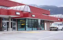
The West Kootenay Regional Airport is owned and operated by the City of Castlegar. The Airport has regular service to both Vancouver International Airport and Calgary International Airport. Nearby airports include Trail Airport, which is 40 km (25 mi) to the south.
Schools
Castlegar is part of School District 20 Kootenay-Columbia and schools in the town include:
Four elementary schools:
- Castlegar Primary School
- Kinnaird Elementary School
- Robson Community School)
- Twin Rivers Elementary School
One high school:
Selkirk College's main campus is also located in Castlegar.
Recreation
There are dozens of great walking trails are located in and near Castlegar.[14] They are maintained by the Castlegar Parks and Trails Society. The area attracts retirees and tourists for its summer and winter sports.
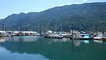
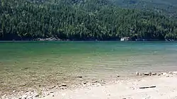
The Columbia River cuts through Castlegar, and to the west along the river are Scotties Marina and Syringa Provincial Park, with boating and camping amenities.
Sports
The city's Collegiate hockey team is the Selkirk College Saints of the BCIHL, who, as of 2016, are 4 time defending league champions. The Castlegar Rebels of the KIJHL are the city's Junior "B" level hockey team.
Other sports activities include The Castlegar Skating Club, Dancing at Turning Pointe Dance Studio and Scottie School of Highland Dance, Castlegar Aquanauts, Castlegar Minor Soccer Association, Selkirk Challengers Gymnastics Club, Castlegar Minor Hockey, Baseball, Lacrosse, Golf, Curling, Tennis, Volleyball, Basketball programs, Kootenay Jiu Jitsu Academy, and Many yoga/fitness etc. programs are offered at the Castlegar Community Complex, West Kootenay Minor Football Association and Castlegar Sentinels Football Club.
| Club | League | Sport | Venue | Established | Championships |
|---|---|---|---|---|---|
| Castlegar Rebels | KIJHL | Ice Hockey | Castlegar Community Complex | 1976 | 3 |
Geography
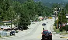
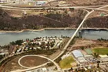
The main street, Columbia Avenue, runs the length of the City of Castlegar. It becomes Highway 22 on the South end, and the Robson Bridge at the North end. Most businesses in Castlegar are located on or just off of Columbia. There are several neighbourhoods in Castlegar, including Downtown, Southridge, Oglow Subdivision, Woodland Park, Grosvenor, Kinnaird, and Blueberry Creek, among others. Outskirts of Castlegar include Robson, Robson West, Brilliant, Raspberry, Pass Creek, Ootischenia, Tarrys, Thrums, and Genelle.
Transportation
The City of Castlegar is considered to be a transportation hub for the region.
Castlegar is the location of the West Kootenay Regional Airport (YCG), the main local airport in the region with flights to both Vancouver and Calgary. It is also the junction of highways 3A, 3, and 22. Highway 22 runs the length of the city, known as Columbia Avenue. At the North End, Columbia enters the Robson Bridge, carrying traffic to the rural suburb of Robson, which is accessed via Broadwater Road.
A small highway interchange exists where the Robson Access Road meets Highway 3A towards Nelson, British Columbia. Highway 3 bisects the town, providing the main access to the Grovesnor area, and crossing the Columbia River at the Kinnaird Bridge, to Ootischenia. Highway 3A and Highway 3 both provide routes through Ootischenia. Highway 22 also connects to Blueberry. To the North, Highway 3A heads to Nelson. To the South, Highway 22 leads to Trail, British Columbia; to the East, Highway 3 Leads to Salmo, British Columbia, and to the West to Grand Forks, British Columbia.
Notable residents
- Felix Belczyk, former alpine skier
- Earle Connor, Paralympic amputee sprinter
- Travis Green, head coach of the Vancouver Canucks
- Shawn Hook, Canadian singer/songwriter
- Dane Jackson, retired ice hockey player
- Steve Junker, retired ice hockey player
- Doug Kostynski, retired ice hockey player
- Darcy Martini, retired ice hockey player
References
- City Council Members
- "Eight B.C. Neighbourhoods in Canada's top 100 for most promising growth".
- "Nelson Star, 20 Sep 2014". www.nelsonstar.com.
- "Nelson Star, 16 Sep 2013". www.nelsonstar.com.
- "Nelson Star, 22 Sep 2013". www.nelsonstar.com.
- Mitchell, Andy (2011). Arthur Kinnaird First Lord of Football. p. 136. ISBN 978-1463621117.
- Census profile, 2016 Census. Statistics Canada https://www12.statcan.gc.ca/census-recensement/2016/dp-pd/prof/details/page.cfm?Lang=E&Geo1=POPC&Code1=0146&Geo2=PR&Code2=59&Data=Count&SearchText=Castlegar&SearchType=Begins&SearchPR=01&B1=All&GeoLevel=PR&GeoCode=0146&TABID=1. Missing or empty
|title=(help) - , Community Profiles from the 2006 Census, Statistics Canada - Census Subdivision
- , Aboriginal Peoples - Data table
- "Daily Data Report for July 1924". Environment Canada. 31 October 2011. Retrieved 27 February 2017.
- "Daily Data Report for July 1926". Environment Canada. 31 October 2011. Retrieved 27 February 2017.
- "Canadian Climate Normals 1981-2010 Station Data". Environment Canada. 25 September 2013. Retrieved 27 February 2017.
- "Daily Data Report for June 2015". Environment Canada. 31 October 2011. Retrieved 27 February 2017.
- "Hiking".
- "Archived copy". Archived from the original on 28 February 2018. Retrieved 25 June 2009.CS1 maint: archived copy as title (link)
- Climate data was recorded at Castlegar from July 1916 to June 1963 and at Castlegar Airport from December 1965 to present.
External links
| Wikivoyage has a travel guide for Castlegar. |
| Subdivisions |  | |
|---|---|---|
| Communities | ||
| Metro areas and agglomerations | ||
| Cities |
| |
| ||
| Authority control |
|---|