Trail Airport
Trail Airport (IATA: YZZ, TC LID: CAD4) is located 6.1 nautical miles (11.3 km; 7.0 mi) southeast of Trail, British Columbia, Canada and is situated in a valley beside the Columbia River. The airport serves both Trail and nearby Nelson and Castlegar.
Trail Regional Airport | |||||||||||
|---|---|---|---|---|---|---|---|---|---|---|---|
| Summary | |||||||||||
| Airport type | Public | ||||||||||
| Owner/Operator | City of Trail | ||||||||||
| Serves | West Kootenay | ||||||||||
| Location | Trail, British Columbia | ||||||||||
| Time zone | PST (UTC−08:00) | ||||||||||
| • Summer (DST) | PDT (UTC−07:00) | ||||||||||
| Elevation AMSL | 1,427 ft / 435 m | ||||||||||
| Coordinates | 49°03′20″N 117°36′33″W | ||||||||||
| Website | http://www.trail.ca/en/regional-airport.asp | ||||||||||
| Map | |||||||||||
 YZZ Location in British Columbia | |||||||||||
| Runways | |||||||||||
| |||||||||||
Source: Canada Flight Supplement[2] | |||||||||||
The airport consists of one 4,001 ft × 75 ft (1,220 m × 23 m) asphalt runway and provides a GPS approach from the north (runway 16) and the south (runway 34).
Since April 10, 2006, Pacific Coastal has been flying into the airport using their Beechcraft 1900s, and occasionally their bigger Saab 340s.
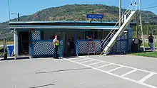
In December 2017, with funding from the B.C. Air Access Program, the City of Trail offers a new 4,200 sq.ft. Airport Terminal Building (ATB) to accommodate the 22,000+ yearly travelers an even better travel experience with designated drop-off and pick-up zones, ample short-term and long-term parking, and a spacious waiting area.
Airlines and destinations
| Airlines | Destinations |
|---|---|
| Pacific Coastal Airlines | Vancouver |

The Trail Airport offers frequent flights to Vancouver.
References
- "Airline and Airport Code Search". IATA. Retrieved 29 April 2016.
- Canada Flight Supplement. Effective 0901Z 16 July 2020 to 0901Z 10 September 2020.
External links
- For airport homepage see http://www.trail.ca/en/regional-airport.asp
- For airport information see http://www.trail.ca/en/Airport-Information.asp
- For airport economic development information see http://www.trail.ca/en/Airport-Economic-Development.asp
- For airport news see http://www.trail.ca/en/Trail-Regional-Airport-News.asp
- For airport webcams see http://www.trail.ca/en/Live-Web-Cam.asp
- For airline information see http://www.trail.ca/en/Airline-Information.asp
| By name | |
|---|---|
| By location indicator | |
| By province/territory | |
| By area | |
| National Airports System | |
| Related | |
| |
