Trail, British Columbia
Trail is a city in the West Kootenay region of the Interior of British Columbia, Canada. It was named after the Dewdney Trail, which passed through the area.[3] The town was first call Trail Creek or Trail Creek Landing, and the name was shortened to Trail in 1897.[4]
Trail | |
|---|---|
| City of Trail | |
 | |
 Coat of arms | |
| Motto(s): Explore Your Trail | |
 Trail Location of Trail in British Columbia | |
| Coordinates: 49°05′40″N 117°42′33″W | |
| Country | Canada |
| Province | British Columbia |
| Region | Kootenays |
| Regional district | Kootenay Boundary |
| Government | |
| • Type | Elected city council |
| • Mayor | Lisa Pasin[1] |
| • Governing body | Trail City Council |
| • MP | Richard Cannings (NDP) |
| • MLA | Katrine Conroy (BC NDP) |
| Area | |
| • Total | 34.93 km2 (13.49 sq mi) |
| Elevation | 440 m (1,440 ft) |
| Population (2016)[2] | |
| • Total | 7,709 |
| Time zone | UTC-8 (PST) |
| Forward sortation area | V1R |
| Area code(s) | 250 / 778 / 236 |
| Highways | 3B 22 |
| Waterways | Columbia River |
| Website | City of Trail |
Geography
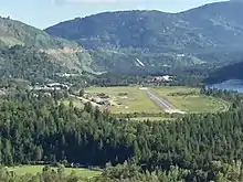
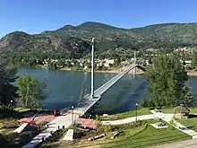
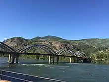
Trail has an area of 34.78 km2 (13.43 sq mi). The city is located on both banks of the Columbia River, approximately 10 km (6.2 mi) north of the United States border. This section of the Columbia River valley is located between the Monashee Mountains to the west and the Selkirk Mountains to the east. The Columbia flows directly north-south from Castlegar, turns east near downtown Trail, and then meets the Canada–United States border at Waneta and the Pend d'Oreille River.
Summer climate in Trail is generally hot and dry with moderately cool nights. Temperatures often exceed 35 °C (95 °F) during summer afternoons, average 29 °C (84 °F). Thunderstorms are common during the late-Spring and Summer season, often moving into the valley from the south. The fall months bring dense river fog, especially overnight and in the morning, as a cold air inversion lingers above the relatively warm river surface. Winters are mild to cold with periods of moderate snowfall. Nearby villages such as Warfield and Fruitvale often receive greater amounts of snow due to higher elevation.
The Monashee Mountains are the first major mountain range east of the Coastal Mountains to intercept moisture laden westerly flow from the Pacific Ocean. As a result, areas west of Trail, including the Christina Range, Rossland Range, the city of Rossland, and the Blueberry-Paulson section of the Crowsnest Highway (Highway 3) receive greater amounts of winter precipitation, mostly in the form of heavy snow. Vegetation in the Trail area, although fairly lush, is noticeably drier than other areas with a more westerly aspect.
Demographics
According to Statistics Canada, Trail's population was 7,709 during the Canada 2016 Census.[2]
The city is also noted for its large Italian community. There are 1,320 people in Trail with Italian ancestry (17.8%).[5]
| Canada 2016 Census | Population | % of Total Population | |
|---|---|---|---|
| Visible minority group | Chinese | 65 | 0.9% |
| South Asian | 45 | 0.6% | |
| Black | 40 | 0.5% | |
| Filipino | 55 | 0.7% | |
| Latin American | 30 | 0.4% | |
| Arab | 0 | 0% | |
| Southeast Asian | 10 | 0.1% | |
| West Asian | 0 | 0% | |
| Korean | 0 | 0% | |
| Japanese | 30 | 0.4% | |
| Other visible minority | 0 | 0% | |
| Mixed visible minority | 20 | 0.3% | |
| Total visible minority population | 295 | 4% | |
| Aboriginal group | First Nations | 220 | 3% |
| Métis | 395 | 5.3% | |
| Inuit | 0 | 0% | |
| Total Aboriginal population | 645 | 8.7% | |
| European Canadian | 6,480 | 87.3% | |
| Total population | 7,420 | 100% | |
Education and employment
Trail is the location of the head office of the Kootenay Boundary Regional District, which is one of the city's employers.
Trail is part of School District 20 Kootenay-Columbia and schools in the town include:
- Glenmerry Elementary School (Public elementary school K-7)
- J. Lloyd Crowe Secondary School (Public secondary school 8-12)
- James L Webster Elementary School (Public elementary school K-7.)
- St. Micheals Catholic School (Independent elementary school K-7)
- Kootenay-Columbia Learning Centre (Public school 6-12)
School district
The school district in the Greater Trail area is focused on improving the district and schools and has a focused, well organized improvement plans in place. The strategies selected to achieve the goals are a blend of research, best practice, and innovative thinking.
In 2007, the J. Lloyd Crowe Secondary School Replacement program started the construction of a new facility in Trail to replace the existing school that was built in the late 1950s. The new facility opened in September 2009.
Education
Trail’s statistics differ sharply from that of the province in the percentage of the population aged 45–64 with a trades certificate or diploma: Trail—26%, compared to BC—14%. This is directly attributable to Teck Resources and the diversified mining and metals company's presence in the area. The percentage of this age group with a university level education is also very different: Trail—12%, compared to BC—22%. The general picture is a working population heavily geared to the trades and historically very reliant on Teck Cominco for employment.
Economic situation
Employing approximately 1,800 people, Teck Resources (formerly Cominco) is the region’s largest employer. The average age of an employee at Teck Resources' Trail operation is 47. It is anticipated that within 15 years Teck Resources' Trail operation will have a completely new and different labour force. A younger and perhaps more technical labour force will most likely replace those that are retiring. The big picture for the area is one of an aging population which brings about ongoing employment opportunities in the area.
The City of Trail is also home to the largest hospital in the West Kootenay region.
Trail smelter
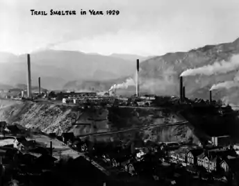
In February 1896, Fritz Augustus Heinze opened his British Columbia Smelting and Refining Company smelter at Trail to process ore brought from Rossland on his Columbia and Western Railway. The concentrate from the smelter was transported to Butte, Montana, for refining. The plant capacity was soon increased from about 150 to 400 tons per day. However, with the supply of Rossland ore largely going south to Northport, the plant was unprofitable. The output was 50 per cent pure copper at best, and the yellow clouds of sulfur dioxide became health hazards for the region.
When the Canadian Pacific Railway (CP) expressed interest in buying the Columbia and Western Railway (C&W), Heinze insisted the package include the Trail smelter. In February 1898, CP bought the C&W for $600,000, and the smelter for $200,00. Heinze retained several other holdings. CP created the Canadian Smelting Works to run the plant. CP's new Crowsnest Pass branch supplied cheap coal, and the new Bonnington Falls dam provided electricity. That August, new blast furnaces increased efficiency and tall chimneys lifted the toxic smoke farther above Trail.
Since lead was the most common ore in the region, the company built two lead furnaces, which were operational by the end of 1901. The next year, the federal government offered a subsidy of five dollars for each ton of lead smelted in Canada. However, the concentrate still required refining at the American Smelting and Refining Company's plant in Tacoma, Washington. To address this problem, by the end of 1902, Trail opened the first commercial electrolytic refining process in the world, producing pure lead, pure copper, fine silver and gold. In 1906, the Consolidated Mining and Smelting Company of Canada (CM&S), a consortium comprising the smelter and certain Red Mountain mines at Rossland, was formed. CP had a 54 per cent holding. After the Northport smelter closed in 1921, Trail remained the sole operator in the region.
By 1925, the 250-acre plant employed 2,100 men and comprised a lead plant, an electrolytic zinc plant, a copper smelter, a copper refinery, a silver and gold refinery, plants for making bluestone, hydrofluosillicic acid and sulfuric acid, a foundry, a machine shop and round-house, and a copper rod mill. That year, CM&S processed 380,000 tons of ores and concentrates at Trail to recover 21,352 ounces of gold, nearly 4.5 million ounces of silver, 9,500 tons of copper, 117,500 tons of lead and almost 50,000 tons of zinc.[6]
By the end of World War I, the smoke pollution had devastated the surrounding district. During the following decades, this triggered the Trail Smelter dispute, which resulted in decades of legal action. This case, known commonly as the "Trail smelter arbitration", is a landmark in environmental law,[7] as it helped to establish the "polluter pays" principle for transnational pollution issues.[8]
In 1966, the company name changed to Cominco. Over the following decades, the smelter spent millions on pollution control.[6] In 1975, the soils in some parts of Trail were found to be contaminated with lead and certain other heavy metals (arsenic, cadmium, zinc) to levels above regulatory limits.[9] The monitored lead levels in the blood of local school children fell from high that year to insignificant 30 years later.[6]
In 2007, a free testing program was instituted, with removal of above-limit topsoils in residential yards (with a priority focus on families with young children).[10] Teck provides funding for this ongoing operation. Because of improvements in smelting processes and emissions controls over the years, the existing contamination is attributed to smelting activities that pre-date the 1997 adoption of newer technologies.[11]
Manhattan Project
As its contribution to the Manhattan Project's P-9 Project, Cominco built and operated a 1000 to 1200 pound per month (design capacity) electrolytic heavy water plant at Trail, which operated from 1943 to 1956. Lt-Col Nichols noted environmental damage from emissions to the "beautiful valley and mountain slopes" in the first half of 1943.[12][13][14][15]
Attractions
Trail Memorial Centre & Sports Hall of Memories
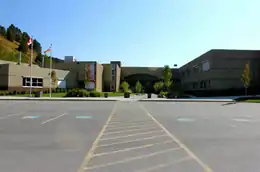
The Trail Memorial Centre currently plays host to the Trail & District Public Library, the Trail Smoke Eaters hockey team, the Trail Museum, and the Sports Hall of Memories, in addition to many local sports facilities. This historic landmark, located at 1051 Victoria Street, was home to two world championship Smoke Eaters teams.
The Trail Memorial Centre is a hub of civic activity year-round, and has been a focal point of the community since its inception.
River Activities and Music in the Park at Gyro Park in Trail
Located at 1090 Charles Lakes Drive in East Trail on the route to Sunningdale, Gyro Park is the home to Music in the Park during the summer. Listen to the melodic tunes under the gazebo in Gyro Park, where visitors enjoy live music Thursdays in July and August. During long hot summer days, Gyro Park is extremely popular with locals and visitors to the area who enjoy a day at the beach.
"The Onions" and other popular river currents that wind between the rocks on the East banks of the Columbia River, are a popular summer magnet for river activity. Often, throughout the summer, an abundance of avid swimmers and rapid paddlers with a deep respect of the Columbia River dare to navigate the frosty swift waters to ride the waves, such as the local favorite "Onions" river current at Gyro Park beach.
Teck Cominco Interpretive Centre
Trail is home to the largest non-ferrous lead and zinc smelter in the world and visitors can learn more about the areas largest employer by taking the 2.5 hour industrial tour of the Teck (Cominco) smelter which can be arranged in the Teck Cominco Interpretive Centre through the Trail & District Chamber of Commerce office located above the Toronto-Dominion Bank, in the heart of downtown Trail.[16] This centre is the starting point for the free tours beginning at 10 am, Monday to Friday during the summer; by appointment from September to May. Learn about the plants' operations in the mini-science centre featuring hands-on exhibits for the whole family.
View video presentations and displays which exhibit sophisticated environmental monitoring systems installed in the Trail area by Teck. Other presentations illustrate the history of Cominco's Trail smelting operations and provide information on career opportunities in the industry.
The Historic Gulch
In the early 1900s a large influx of Italian immigrants lent a distinctive character to "The Gulch" which is located at the entrance to Trail accessed by the Schofield Highway which drops down the long grade down from the city of Rossland and the village of Warfield and sub-division of Annabel onto Rossland Avenue.
This neighbourhood which runs the length of Rossland Avenue is known as "the Gulch." Originally called the "Dublin Gulch" in the very early days, it eventually became known as "The Gulch" as it filled up with Italians who chose not to live on the original Trail townsite. The Gulch starts as throat of Trail Creek narrows between the high, sandy slope of Smelter Hill on its left bank and the West Trail bank where early pioneer houses were built by immigrants as the purchased properties along the west bank steep terrain.
In the early pioneer days, industrious Chinese launderers and cooks spent time gardening in the defile of the Gulch. Few of these immigrants ever acquired rights to own land in the Gulch and their gardens were gradually displaced by Italians and other European working families who terraced their properties into level plots. Despite the steep terrain, these immigrant families planted vegetable gardens reminiscent of the old country, fed by plenty of water from Trail Creek and the hot summer sun.
The Gulch is home to shops and the Terra Nova hotel, located at the entrance to Trail’s central business district at the foot of Rossland Avenue.
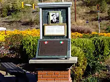
Home of Champions
The Greater Trail Area is known as the Home of Champions, in recognition of those who reside in the area, or are from the area, and have excelled in their chosen field of endeavour.
In 1995, Kootenay Savings Credit Union was seeking a project that would represent their commitment and appreciation to the Greater Trail community. The Credit Union decided to sponsor the construction of a monument which was constructed in the summer of 1996 outside their offices in Trail's downtown that would honour the "Champions" of the Greater Trail area in Sports, Industry and Lifestyle.
A society was formed to establish criteria for selection of the persons to be honoured on the monument. The monument was constructed in the summer of 1996 and forty-three champions were selected to be honoured at the inaugural dedication ceremony which took place on September 28, 1996. To date, eighty-nine individuals and organizations have been honoured with a place on the Home of Champions monument.[17]
The Home of Champions monument project is an ongoing one, managed by the City of Trail. Additional persons will be honoured regularly for their special contribution to the social, cultural, economic and educational fabric of the community.
Notable people
- John Rogers Anderson, Chief of the Defence Staff
- Jason Bay, former MLB player
- Lauren Bay, Canadian National Softball Team and National Pro Fastpitch pitcher
- Ed Cristofoli, former NHL player
- Craig Cunningham, former NHL Player
- Adam Deadmarsh, former NHL player, won Stanley cup in 1996 with the Colorado Avalanche
- Dallas Drake, former NHL player, won Stanley Cup in 2008 with the Detroit Red Wings
- Landon Ferraro, current NHL player for the Minnesota Wild
- Ray Ferraro, former NHL player and current TSN analyst
- Bruno Freschi, architect for Expo 86
- Ken Georgetti, former President of the Canadian Labour Congress
- Robert Hampton Gray, one of the last Canadians to die in WWII and the last Canadian recipient of the Victoria Cross
- Tom Harrison, former MLB pitcher for the Kansas City A's, now known as the Oakland Athletics
- Shawn Hook,singer
- Shawn Horcoff former NHL player, most notably a former captain of the Edmonton Oilers
- Barret Jackman, former NHL player
- Mike Kobluk of the Chad Mitchell Trio
- Richard Kromm, former NHL player
- Kerrin Lee-Gartner, Canadian Olympic Women's Ski Team, Downhill Olympic Gold Medal 1992
- Gary Lunn, former Canadian MP and Cabinet Minister
- Cesare Maniago, former NHL player
- Seth Martin, former NHL player
- Mike Matteucci, former NHL player
- Steve McCarthy, current AHL player with Springfield Falcons, former NHL player
- Tom McVie, former professional hockey player and NHL Coach and current Scout for Boston Bruins
- Ben McPeek, composer, arranger, conductor, and pianist
- Bill McEwan, President and CEO of Sobeys
- Faron Moller, President of the British Colloquium for Theoretical Computer Science
- Martin Popoff, heavy metal music journalist
- Garth Rizzuto, former NHL player
- David Sylvester (academic)- Principal of King's University College (University of Western Ontario)
- Steve Tambellini, former NHL player & former GM of the Edmonton Oilers
See also
References
- "Inside City Hall". Trail BC. Retrieved 2014-11-16.
- Statistics Canada (2016 Census). Trail, City [Census subdivision], British Columbia and Canada [Country]
- Barman, Jean The West Beyond the West, University of Toronto Press, 2007, p. 130.
- Hamilton, William (1978). The Macmillan Book of Canadian Place Names. Toronto: Macmillan. p. 51. ISBN 0-7715-9754-1.
- Ethnic Origin, both sexes, age (total), Trail, 2016 Census
- "Trail". www.crowsnest-highway.ca.
- Parrish, A. (2005). "Trail Smelter Deja Vu: Extraterritoriality, International Environmental Law, and the Search for Solutions to Canada-U.S. Transboundary Water Pollution Disputes". www.ssrn.com.
- "Trail Smelter Arbitration, 1938/1941". www.archive.org. University of Idaho.
- Profiles on Remediation Projects, Teck Cominco Lead-Zinc Smelter, Trail, BC, BC Ministry of Environment, January 2009
- "Trail Area Health and Environment Program. Soil Management Program". www.thep.ca.
- "Canadian Environmental Health Atlas: Trail BC". www.ehatlas.ca.
- Chris Waltham (20 June 2002). "An Early History of Heavy Water". arXiv:physics/0206076.
- "Project '9' - Heavy-Water (Deuterium) Production". The Manhattan Project Heritage Preservation Association. Retrieved 2007-12-06.
- Manhattan District History, Book III, The P-9 Project (PDF) (Report). United States Department of Energy. 1947-04-08. p. 99. Retrieved 2019-02-16. The original design production was 1000 lbs./month, later increased to 1200 lbs./month. Maximum production was 1330 lbs./month.
- Nichols, Kenneth (1987). The Road to Trinity. New York: William Morrow. ISBN 068806910X.CS1 maint: ref=harv (link) p97
- "Teck Cominco Interpretive Centre". Kootenay Rockies Tourism. Retrieved 11 May 2015.
- Trail Historical Society
External links
| Wikivoyage has a travel guide for Trail. |
![]() Media related to Trail, British Columbia at Wikimedia Commons
Media related to Trail, British Columbia at Wikimedia Commons
| Subdivisions | 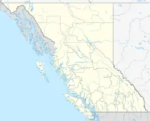 | |
|---|---|---|
| Communities | ||
| Metro areas and agglomerations | ||
| Cities |
| |
| ||
| Authority control |
|---|