Cilegon
Cilegon is a major coastal industrial city in Banten province, Indonesia, covering 175.51 km2 (67.76 sq mi). It is located on the island of Java. The city has a census population of 374,464 in 2010; the latest official estimated population was 442,803 for mid 2020.[3]
Cilegon | |
|---|---|
| City of Cilegon | |
 Coat of arms | |
| Nickname(s): Steel City | |
| Motto(s): Akur Sedulur Jujur Adil Makmur (Get along fellow, Honest fair prosperous) | |
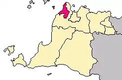 Location within Banten | |
| Coordinates: 6.002685°S 106.011202°E | |
| Country | |
| Province | |
| Administrative City | 1987 |
| Municipality | 27 April 1999 |
| City | 4 September 1999 [1] |
| Government | |
| • Mayor | Tb. Iman Ariyadi |
| • Vice Mayor | Edi Ariadi |
| Area | |
| • Total | 175.51 km2 (67.76 sq mi) |
| Population (2020) | |
| • Total | 442,803 |
| • Density | 2,500/km2 (6,500/sq mi) |
| [2] | |
| Time zone | UTC+7 (Indonesia Western Time) |
| Postcodes | 42400 |
| Area code | (+62) 254 |
| Website | cilegon |

Among the factories located in Cilegon are Krakatau Steel Company, a vital company in Indonesia, which produces steel for industrial (domestic and foreign) needs, and Asahimas Chemical Company. The other name for Cilegon is "Steel City" since the city is the largest steel producer in Southeast Asia, about 6 million tons of steel produced each year in the Industrial Area Krakatau Steel, Cilegon. Additionally Cilegon is one of the vital state objects. This is because in this town there is a wide range of other vital objects such as the Merak Harbour, Krakatau Steel Industrial Zone (including the PT. Krakatau Steel Tbk, Asahimas, Siemens, KS - POSCO joint venture, Chandra Asri, and Pertamina), PLTU Suralaya, Power plant Krakatau, Krakatau Tirta Industrial Water Treatment Plant, The Sunda Strait Bridge Construction (Lot Plan) & Sunda Strait Industrial Zones.
Geography
Cilegon is located on the most northwest coast of Java island, at the mouth of the Cilegon River on Ciwandan Bay, which is an inlet of the Sunda Strait. It is administratively a semi-enclave within Serang Regency, as it borders with Serang Regency in the east and south, while it borders with Sunda Strait in the north and west.
Administrative districts
The City of Cilegon is divided into eight districts (kecamatan), tabulated below with their areas and population totals from the 2010 Census[4] and the latest official estimates for mid 2019.[5] The table also includes the number of administrative villages (urban kelurahan) in each district, and its postal codes.
| Name | Area in km2 | Population Census 2010[6] | Population Estimate mid 2019[7] | Number of villages | Post codes |
|---|---|---|---|---|---|
| Ciwandan | 51.81 | 42,921 | 48,711 | 6 | 42441-42447 |
| Citangkil | 22.98 | 65,073 | 78,450 | 7 | 42441-42444 |
| Pulomerak (a) | 19.86 | 43,060 | 45,722 | 4 | 42431-42439 |
| Purwakarta | 15.29 | 38,479 | 40,304 | 6 | 42431-42437 |
| Grogol | 23.38 | 38,538 | 46,868 | 4 | 42436-42438 |
| Cilegon (district) | 9.15 | 39,465 | 46,228 | 5 | 42415-42419 |
| Jombang | 11.55 | 60,415 | 69,368 | 5 | 42411-42416 |
| Cibeber | 21.49 | 46,608 | 61,554 | 6 | 42422-42427 |
| Totals | 175.51 | 374,464 | 437,205 | 43 |
Notes: (a) including 5 small offshore islands.
Climate
Cilegon has a hot and humid climate near the boundary between tropical rainforest (Af) and tropical monsoon climate (Am) according to the Köppen climate classification system. Despite being located relatively close to the equator, the city has distinct wet and dry seasons. The wet season in Cilegon covers the majority of the year, running from October through May. The remaining four months forms the city's dry season. Located in the most western part of Java, Cilegon's wet season rainfall peak is January with average monthly rainfall of 319 millimetres (12.6 in), and its dry season low point is August with a monthly average of 71 millimetres (2.8 in).
| Climate data for Cilegon | |||||||||||||
|---|---|---|---|---|---|---|---|---|---|---|---|---|---|
| Month | Jan | Feb | Mar | Apr | May | Jun | Jul | Aug | Sep | Oct | Nov | Dec | Year |
| Average high °C (°F) | 30.6 (87.1) |
31.1 (88.0) |
31.6 (88.9) |
32.2 (90.0) |
32.5 (90.5) |
32.4 (90.3) |
32.4 (90.3) |
32.4 (90.3) |
32.8 (91.0) |
33.0 (91.4) |
32.6 (90.7) |
31.8 (89.2) |
32.1 (89.8) |
| Daily mean °C (°F) | 26.6 (79.9) |
26.9 (80.4) |
27.2 (81.0) |
27.5 (81.5) |
27.7 (81.9) |
27.4 (81.3) |
27.1 (80.8) |
27.0 (80.6) |
27.4 (81.3) |
27.8 (82.0) |
27.7 (81.9) |
27.4 (81.3) |
27.3 (81.2) |
| Average low °C (°F) | 22.7 (72.9) |
22.8 (73.0) |
22.8 (73.0) |
22.9 (73.2) |
23.0 (73.4) |
22.4 (72.3) |
21.9 (71.4) |
21.7 (71.1) |
22.1 (71.8) |
22.6 (72.7) |
22.9 (73.2) |
23.0 (73.4) |
22.6 (72.6) |
| Average rainfall mm (inches) | 319 (12.6) |
269 (10.6) |
209 (8.2) |
157 (6.2) |
129 (5.1) |
94 (3.7) |
80 (3.1) |
71 (2.8) |
73 (2.9) |
116 (4.6) |
169 (6.7) |
240 (9.4) |
1,926 (75.9) |
| Source: Climate-Data.org[8] | |||||||||||||
Media
Newspaper
- Radar Banten (Jawa Pos)
Radio
- 91,8 Top FM Cilegon
- 95,3 FM Banten Radio
- 96,9 FM Sam Radio
- 102,0 Cilegon Mandiri FM (Siaran Pemda)
- 105,2 Cilegon Pass FM
- 107,7 Gema Suara Tercinta
- 107,9 Flash Radio FM
References
- "Archived copy". Archived from the original on 2012-06-23. Retrieved 2012-09-23.CS1 maint: archived copy as title (link)
- Badan Pusat Statistik, Jakarta, 2020.
- Badan Pusat Statistik, Jakarta, 2020.
- Biro Pusat Statistik, Jakarta, 2011.
- Badan Pusat Statistik, Jakarta, 2020.
- Biro Pusat Statistik, Jakarta, 2011.
- Badan Pusat Statistik, Jakarta, 2020.
- "Climate: Cilegon". Climate-Data.org. Retrieved 12 November 2020.
External links
| Wikivoyage has a travel guide for Cilegon. |
- (in Indonesian) Cilegon Government Site
| 2,000,000 and more | |
|---|---|
| 1,000,000–1,999,999 | |
| 500,000–999,999 | |
| 200,000–499,999 | |