Conejo Formation
The Conejo Formation (Spanish: Formación Conejo, K2C, Kscn) is a fossiliferous geological formation of the Altiplano Cundiboyacense, Eastern Ranges of the Colombian Andes. The uppermost unit of the Villeta Group, a sequence of shales and sandstones dates to the Late Cretaceous period; Turonian, Coniacian and Santonian epochs, and has a maximum thickness of 1,022 metres (3,353 ft).
| Conejo Formation Stratigraphic range: Turonian-Santonian ~90–83.6 Ma | |
|---|---|
| Type | Geological formation |
| Unit of | Villeta Group |
| Underlies | Guadalupe Group |
| Overlies | La Frontera Formation |
| Thickness | up to 1,022 m (3,353 ft) |
| Lithology | |
| Primary | Sandstone, shale |
| Other | Limestone |
| Location | |
| Coordinates | 5°35′40.7″N 73°12′59.6″W |
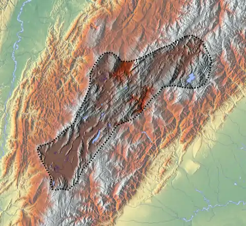
| Region | Altiplano Cundiboyacense Eastern Ranges, Andes |
| Country | |
| Type section | |
| Named for | El Conejo Hill |
| Named by | Renzoni |
| Location | Toca, Boyacá |
| Year defined | 1981 |
| Coordinates | 5°35′40.7″N 73°12′59.6″W |
| Region | Cundinamarca, Boyacá |
| Country | |
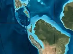 Paleogeography of Northern South America 90 Ma, by Ron Blakey | |
Etymology
The formation was named in 1967 and published in 1981 by Renzoni, named after El Conejo Hill in Pontezuela, Toca, Boyacá, west of the Copa Reservoir.[1][2]
Description
Lithologies
The Conejo Formation is characterised by a sequence of calcareous sandstones, containing ammonites, shales and the uppermost part sandstone and limestone banks.[3] In the Conejo Formation, fossils of Protopholoe colombiana, Archaeglobigerina blowi, Dicarinella concavata, Dicarinella primitiva, Sigalitruncana sigali, Marginotruncana sp. ct. M. renzi, Marginotruncana angusticarenata, Marginotruncana sp. cf. M.sinuosa, Rosita tornicata, Heterohelix globulosa, Heterohelix reussi, Whiteinella inornata, Hedbergella sp., and the ammonites Gloriaceras correai, Protexamites cucaitaense and Codazziceras scheibei have been found.[4][5][6]
Stratigraphy and depositional environment
The Conejo Formation is the uppermost unit of the Villeta Group.[7] It overlies the La Frontera Formation and is overlain by the Guadalupe Group. The age has been estimated on the basis of ammonites to be ranging from Turonian to Santonian.[8] Stratigraphically, the lower part of the formation is time equivalent with the upper part of the Chipaque,[8] and Loma Gorda Formations.[7]
Outcrops
The type locality of the Conejo Formation is located close to El Conejo Hill in Pontezuela, Toca, Boyacá.[2] Other outcrops of the Conejo Formation have been noted in Cucaita,[4][5] the urban areas of Boyacá and Ventaquemada, around the Puente de Boyacá, south of Pesca, west of Siachoque,[9] surrounding Chiquinquirá and Ubaté,[10] between Chivatá and Oicatá,[2] east of Paipa,[11] west of Tibacuy,[12] north and south of Albán, southeast of Cachipay, east of Anolaima, and San Antonio del Tequendama, Cundinamarca.[13]
Regional correlations
| Age | Paleomap | VMM | Guaduas-Vélez | W Emerald Belt | Villeta anticlinal | Chiquinquirá- Arcabuco | Tunja- Duitama | Altiplano Cundiboyacense | El Cocuy | ||||
|---|---|---|---|---|---|---|---|---|---|---|---|---|---|
| Maastrichtian | 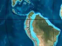 | Umir | Córdoba | Seca | eroded | Guaduas | Colón-Mito Juan | ||||||
| Umir | Guadalupe | ||||||||||||
| Campanian | Córdoba | ||||||||||||
| Oliní | |||||||||||||
| Santonian | La Luna | Cimarrona - La Tabla | La Luna | ||||||||||
| Coniacian | Oliní | Conejo | Chipaque | ||||||||||
Güagüaquí | Loma Gorda | undefined | La Frontera | ||||||||||
| Turonian | | Hondita | La Frontera | Otanche | |||||||||
| Cenomanian | Simití | hiatus | La Corona | Simijaca | Capacho | ||||||||
| Pacho Fm. | Hiló - Pacho | Churuvita | Une | Aguardiente | |||||||||
| Albian | 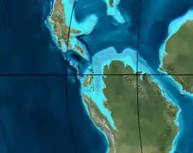 | Hiló | Chiquinquirá | Tibasosa | Une | ||||||||
| Tablazo | Tablazo | Capotes - La Palma - Simití | Simití | Tibú-Mercedes | |||||||||
| Aptian | Capotes | Socotá - El Peñón | Paja | Fómeque | |||||||||
| Paja | Paja | El Peñón | Trincheras | Río Negro | |||||||||
| La Naveta | |||||||||||||
| Barremian | 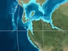 | ||||||||||||
| Hauterivian | Muzo | Cáqueza | Las Juntas | ||||||||||
| Rosablanca | Ritoque | ||||||||||||
| Valanginian | Ritoque | Furatena | Útica - Murca | Rosablanca | hiatus | Macanal | |||||||
| Rosablanca | |||||||||||||
| Berriasian | 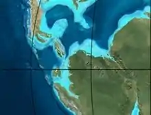 | Cumbre | Cumbre | Los Medios | Guavio | ||||||||
| Tambor | Arcabuco | Cumbre | |||||||||||
| Sources | |||||||||||||
See also
References
- Montoya & Reyes, 2005, p.29
- Acosta & Ulloa, 2001, p.43
- Montoya & Reyes, 2005, p.30
- Luque et al., 2015
- Tchegliakova & Pérez, 1995
- Acosta & Ulloa, 2002, p.48
- Acosta & Ulloa, 2002, p.22
- Montoya & Reyes, 2005, p.34
- Plancha 191, 1998
- Plancha 190, 2009
- Planchas 171 & 191, 2005
- Plancha 246, 1998
- Plancha 227, 1998
Bibliography
- Acosta, Jorge E., and Carlos E. Ulloa. 2002. Mapa geológico del Departamento de Cundinamarca 1:250,000 - Memoria Explicativa, 1–108. INGEOMINAS.
- Acosta Garay, Jorge, and Carlos E. Ulloa Melo. 2001. Geología de la Plancha 208 Villeta - 1:100,000, 1–84. INGEOMINAS. Accessed 2017-03-16.
- Luque, Javier; Stéphane Hourdez, and Olev Vinn. 2015. A new fossil bristle worm (Annelida: Polychaeta: Aphroditiformia) from the late Cretaceous of tropical America. Journal of Paleontology 89. 257–261. Accessed 2017-04-04.
- Montoya Arenas, Diana María, and Germán Alfonso Reyes Torres. 2005. Geología de la Sabana de Bogotá, 1–104. INGEOMINAS.
- Tchegliakova, Nadejda, and Vladimir Pérez. 1995. Registro de la Zona bioestratigrafica Dicarinella concavata (Foraminiferida) en el Extremo noroccidental de Suramerica (Colombia). Geología Colombiana 19. 131–143. Accessed 2017-04-06.
- Villamil, Tomas. 2012. Chronology Relative Sea Level History and a New Sequence Stratigraphic Model for Basinal Cretaceous Facies of Colombia, 161–216. Society for Sedimentary Geology (SEPM).
Maps
- Ulloa, Carlos E, and Erasmo Rodríguez. 2009. Plancha 170 - Vélez - 1:100,000, 1. INGEOMINAS. Accessed 2017-06-06.
- Renzoni, Giancarlo, and Humberto Rosas. 2009. Plancha 171 - Duitama - 1:100,000, 1. INGEOMINAS. Accessed 2017-06-06.
- Fuquen M., Jaime A, and José F. Osorno M. 2009. Plancha 190 - Chiquinquirá - 1:100,000, 1. INGEOMINAS. Accessed 2017-06-06.
- Renzoni, Giancarlo; Humberto Rosas, and Fernando Etayo Serna. 1998. Plancha 191 - Tunja - 1:100,000, 1. INGEOMINAS. Accessed 2017-06-06.
- Ulloa, Carlos, and Jorge Acosta. 1998. Plancha 208 - Villeta - 1:100,000, 1. INGEOMINAS. Accessed 2017-06-06.
- Montoya, Diana María, and Germán Reyes. 2009. Plancha 209 - Zipaquirá - 1:100,000, 1. INGEOMINAS. Accessed 2017-06-06.
- Terraza, Roberto; Giovanni Moreno; José A. Buitrago; Adrián Pérez, and Diana María Montoya. 2010. Plancha 210 - Guateque - 1:100,000, 1. INGEOMINAS. Accessed 2017-06-06.
- Ulloa, Carlos E; Erasmo Rodríguez, and Jorge E. Acosta. 1998. Plancha 227 - La Mesa - 1:100,000, 1. INGEOMINAS. Accessed 2017-06-06.
- Acosta, Jorge E.; Rafael Guatame; Oscar Torres, and Frank Solano. 1999. Plancha 245 - Girardot - 1:100,000, 1. INGEOMINAS. Accessed 2017-06-06.
- Acosta, Jorge E., and Carlos E. Ulloa. 1998. Plancha 246 - Fusagasugá - 1:100,000, 1. INGEOMINAS. Accessed 2017-06-06.
- Velandia, Francisco, and Héctor Cepeda. 2005. Planchas 171 & 191 - Geología sector del sur del municipio de Paipa (Boyacá) - 1:25,000. INGEOMINAS.
External links
- Gómez, J.; N.E. Montes; Á. Nivia, and H. Diederix. 2015. Plancha 5-09 del Atlas Geológico de Colombia 2015 – escala 1:500,000, 1. Servicio Geológico Colombiano. Accessed 2017-03-16.
