Corang, New South Wales
Corang is a locality in the Queanbeyan–Palerang Regional Council, New South Wales, Australia. It is located on the north side of the Corang River and to the east of the road from Braidwood to Nowra about 46 km north of Braidwood and 75 km southwest of Nowra.[2][3] At the 2016 census, it had a population of 13.[1] It consists mainly of forest and most of it lies in the Morton National Park. Its eastern boundary runs along the Budawang Range and includes Mount Tarn, Sturgiss Mountain and Quiltys Mountain.
| Corang New South Wales | |||||||||||||||
|---|---|---|---|---|---|---|---|---|---|---|---|---|---|---|---|
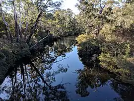 Corang River looking west with Corang on the right and Oallen on the left | |||||||||||||||
Corang Location in New South Wales | |||||||||||||||
| Coordinates | 35°13′03″S 150°07′42″E | ||||||||||||||
| Population | 13 (2016 census)[1] | ||||||||||||||
| Postcode(s) | 2622 | ||||||||||||||
| Location | |||||||||||||||
| LGA(s) | Queanbeyan-Palerang Regional Council | ||||||||||||||
| Region | Southern Tablelands | ||||||||||||||
| County | St Vincent | ||||||||||||||
| Parish | Corang | ||||||||||||||
| State electorate(s) | Monaro | ||||||||||||||
| Federal Division(s) | Eden-Monaro | ||||||||||||||
| |||||||||||||||
Corang had a "half-time" school from 1868 to 1871.[4]
References
- Australian Bureau of Statistics (27 June 2017). "Corang". 2016 Census QuickStats. Retrieved 27 April 2018.

- "Corang". Geographical Names Register (GNR) of NSW. Geographical Names Board of New South Wales. Retrieved 27 April 2018.
- "Corang". OpenStreetMap. Retrieved 27 April 2018.
- "Corang in the School history database search". New South Wales Department of Education. Retrieved 27 April 2018.
This article is issued from Wikipedia. The text is licensed under Creative Commons - Attribution - Sharealike. Additional terms may apply for the media files.