St Vincent County

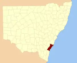
St Vincent County was one of the original Nineteen Counties in New South Wales and is now one of the 141 Cadastral divisions of New South Wales. It included the south coast area encompassing Batemans Bay, Ulladulla, Jervis Bay and inland to Braidwood. The Shoalhaven River is the boundary to the north and west, and the Deua River the boundary to the south.

St. Vincent
Australian Capital Territory
Location in New South Wales
Lands administrative divisions around St. Vincent:
Argyle Camden Camden
Murray St. Vincent Pacific Ocean
Murray Dampier Pacific Ocean

St. Vincent County was named in honour of John Jervis, 1st Earl of St Vincent (1735-1823), Admiral of the Fleet.[1] The electoral district of United Counties of Murray and St Vincent and the electoral district of St Vincent were the first electoral districts for the area, between 1856 and 1859.

In 1852 it had an area of 1,704,844 acres (6,899.26 km2) and population of 2,572.[2]

Parishes within this county

Land in the Parishes of Bherwerre, Beecroft, Farnham and Nowra was transferred to the Commonwealth government in 1915 to become the Jervis Bay Territory, as specified in the Seat of Government Acceptance Act 1909. A full list of parishes found within this county; their current LGA and mapping coordinates to the approximate centre of each location is as follows:

ParishLGACoordinates
AlbertCity of Shoalhaven35°30′54″S 150°15′04″E
AraluenQueanbeyan-Palerang Regional Council35°37′54″S 149°48′04″E
BatemanEurobodalla Shire35°45′54″S 150°12′04″E
BeecroftCity of Shoalhaven35°01′54″S 150°49′04″E
BenandarahEurobodalla Shire35°39′54″S 150°16′04″E
BendouraQueanbeyan-Palerang Regional Council35°30′54″S 149°42′04″E
BettowyndQueanbeyan-Palerang Regional Council35°42′54″S 149°46′04″E
BherwerreCity of Shoalhaven35°08′54″S 150°45′04″E
BolaroEurobodalla Shire35°39′54″S 150°00′04″E
BoolijahCity of Shoalhaven35°02′54″S 150°21′04″E
BorimbadalCity of Shoalhaven34°52′54″S 150°08′04″E
BoyleQueanbeyan-Palerang Regional Council35°29′54″S 149°45′04″E
BoyneCity of Shoalhaven35°25′54″S 150°17′04″E
BraidwoodQueanbeyan-Palerang Regional Council35°24′54″S 149°51′04″E
BrouleeEurobodalla Shire35°50′54″S 150°10′04″E
BruceQueanbeyan-Palerang Regional Council35°21′54″S 149°45′04″E
BuanglaCity of Shoalhaven34°54′54″S 150°27′04″E
BuckenbowraEurobodalla Shire35°44′54″S 150°00′04″E
BudawangCity of Shoalhaven35°26′54″S 149°58′04″E
BuleeCity of Shoalhaven34°59′54″S 150°08′04″E
BurrillCity of Shoalhaven35°20′54″S 150°06′04″E
ClydeEurobodalla Shire35°34′54″S 150°13′04″E
CoghillQueanbeyan-Palerang Regional Council35°29′54″S 149°50′04″E
ConjolaCity of Shoalhaven35°14′54″S 150°27′04″E
CoolumburraCity of Shoalhaven35°02′54″S 150°06′04″E
CorangQueanbeyan-Palerang Regional Council35°12′54″S 150°07′04″E
CroobyarCity of Shoalhaven35°21′54″S 150°18′04″E
CudmirrahCity of Shoalhaven35°10′54″S 150°30′04″E
CurrambeneCity of Shoalhaven34°58′54″S 150°39′04″E
CurrockCity of Shoalhaven35°27′54″S 150°05′04″E
CurrowanEurobodalla Shire35°34′54″S 150°07′04″E
DanjeraCity of Shoalhaven34°57′54″S 150°22′04″E
Durran DurraQueanbeyan-Palerang Regional Council35°21′54″S 149°52′04″E
East NelligenEurobodalla Shire35°39′54″S 150°11′04″E
ElringtonQueanbeyan-Palerang Regional Council35°32′54″S 149°45′04″E
EndrickCity of Shoalhaven35°14′54″S 150°14′04″E
EttremaCity of Shoalhaven34°57′54″S 150°14′04″E
FarnhamCity of Shoalhaven35°07′54″S 150°30′04″E
GobaEurobodalla Shire35°44′54″S 150°08′04″E
JerrawangalaCity of Shoalhaven35°03′54″S 150°27′04″E
JerricknorraQueanbeyan-Palerang Regional Council35°10′54″S 150°00′04″E
KioloaCity of Shoalhaven35°34′54″S 150°19′04″E
Little ForestCity of Shoalhaven35°14′54″S 150°20′04″E
MarloweQueanbeyan-Palerang Regional Council35°15′54″S 149°52′04″E
MeangoraQueanbeyan-Palerang Regional Council35°04′54″S 150°00′04″E
MiloEurobodalla Shire35°40′54″S 149°54′04″E
MogendouraEurobodalla Shire35°51′54″S 150°01′04″E
MogoodCity of Shoalhaven35°28′54″S 150°11′04″E
MongaQueanbeyan-Palerang Regional Council35°29′54″S 149°56′04″E
MongarloweQueanbeyan-Palerang Regional Council35°20′54″S 150°00′04″E
MullendareeEurobodalla Shire35°48′54″S 150°03′04″E
MurrengenburgCity of Shoalhaven35°32′54″S 150°00′04″E
NowraCity of Shoalhaven34°53′54″S 150°30′04″E
NumbaaCity of Shoalhaven34°53′54″S 150°40′04″E
PercyQueanbeyan-Palerang Regional Council35°22′54″S 149°45′04″E
QuieraCity of Shoalhaven34°56′24″S 150°12′04″E
SassafrasCity of Shoalhaven35°07′54″S 150°13′04″E
SeymourQueanbeyan-Palerang Regional Council35°33′54″S 149°50′04″E
St. GeorgeCity of Shoalhaven34°59′54″S 150°13′04″E
TallagandaQueanbeyan-Palerang Regional Council35°39′54″S 149°41′04″E
TallowalCity of Shoalhaven34°52′54″S 150°13′04″E
TermeilCity of Shoalhaven35°28′54″S 150°21′04″E
TianjaraCity of Shoalhaven35°08′54″S 150°21′04″E
TomagaEurobodalla Shire35°51′54″S 150°07′04″E
TomboyeQueanbeyan-Palerang Regional Council35°14′54″S 149°57′04″E
TomerongCity of Shoalhaven34°58′54″S 150°29′04″E
TougaCity of Shoalhaven34°54′54″S 150°07′04″E
UlladullaCity of Shoalhaven35°19′54″S 150°27′04″E
WandrawandianCity of Shoalhaven35°03′54″S 150°33′04″E
West NelligenEurobodalla Shire35°40′54″S 150°05′04″E
Wog WogQueanbeyan-Palerang Regional Council35°15′54″S 150°02′04″E
WollumboolaCity of Shoalhaven34°57′54″S 150°44′04″E
WoodburnCity of Shoalhaven35°23′54″S 150°23′04″E
YadboroCity of Shoalhaven35°22′54″S 150°13′04″E
YalwalCity of Shoalhaven34°52′54″S 150°19′04″E
YerriyongCity of Shoalhaven34°57′54″S 150°27′04″E

References

  1. "St. Vincent". Geographical Names Register (GNR) of NSW. Geographical Names Board of New South Wales.
  2. "Old Welsh Books with English Translations" Archived 2007-05-27 at Archive.today, The Land of Gold: the Companion for the Welsh Emigrant to Australia, 1852
This article is issued from Wikipedia. The text is licensed under Creative Commons - Attribution - Sharealike. Additional terms may apply for the media files.