Marlowe, New South Wales
Marlowe is a locality in the Queanbeyan–Palerang Regional Council, New South Wales, Australia. It is bounded by the left bank of the Mongarlowe River and the right bank of the Shoalhaven River.[2] It lies on the road from Braidwood to Nowra about 24 km north of Braidwood and 96 km southwest of Nowra.[3][4] At the 2016 census, The Australian Bureau of Statistics recorded it as having a population of nil,[1] although it does have at least one house. It consists mainly of forest and grazing country. Marlowe includes the "rural place" and former village of Charleyong in a loop of the Mongarlowe River at 35°14′57″S 149°55′02″E.[5]
| Marlowe New South Wales | |||||||||||||||
|---|---|---|---|---|---|---|---|---|---|---|---|---|---|---|---|
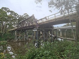 Old and new Charleyong bridges over Mongarlowe River in December 2020. | |||||||||||||||
Marlowe Location in New South Wales | |||||||||||||||
| Coordinates | 35°17′57″S 149°53′02″E | ||||||||||||||
| Population | 0 (2016 census)[1] | ||||||||||||||
| Postcode(s) | 2622 | ||||||||||||||
| Location | |||||||||||||||
| LGA(s) | Queanbeyan-Palerang Regional Council | ||||||||||||||
| Region | Southern Tablelands | ||||||||||||||
| County | St Vincent | ||||||||||||||
| Parish | Marlowe | ||||||||||||||
| State electorate(s) | Monaro | ||||||||||||||
| Federal Division(s) | Eden-Monaro | ||||||||||||||
| |||||||||||||||
The area now known as Marlowe lies on the traditional lands of the Walbanga people.[6]
The first mention of Marlowe (or 'Marlow') was in 1843, as one of the planned townships on the road from Braidwood to Jervis Bay.[7] Following the discovery of gold in the area, an informal settlement, originally known as Taylor's Village, arose around 1854; It was later known as Charleyong.[8] A site for a 'future village' was reserved in 1879, replacing the original village reserve of 1843.[9]
Charleyong experienced renewed prosperity around the turn of the 20th-century, when there was employment building the bridge and operating a gold dredge in the river.[10] The last gold dredge at Charleyong started operating in 1910 but was gone by 1913.[11][12]
Marlowe had a state school from 1869 to 1906, from 1910 to 1931 and from 1935 to 1940, variously described as "provisional", "half-time" or "public". Up to June 1893 it was called Charleyong school and subsequently Marlow school.[13] There was another half-time school at Charleyong in 1928 and from 1930 to 1940.[14]
The village erected a new public hall in 1925[15] and there was still a post office there at the start of the 1950s, both now gone. There are remnants of a cricket ground and tennis courts—rebuilt in 1953—at Charleyong,[16][17] and the settlement's old cemetery.[18][8]
The old Charleyong bridge over the Mongarlowe River is an Allan truss bridge completed in 1901.[17] A reinforced concrete bridge opened on 9 March 2020 has replaced it. The old bridge is expected to be demolished, starting in early 2021,[19] despite some community opposition.[17]
References
- Australian Bureau of Statistics (27 June 2017). "Marlowe". 2016 Census QuickStats. Retrieved 27 April 2018.

- "Marlowe". Google Maps. Retrieved 23 January 2021.
- "Marlowe". Geographical Names Register (GNR) of NSW. Geographical Names Board of New South Wales. Retrieved 23 December 2020.
- "Marlowe". OpenStreetMap. Retrieved 27 April 2018.
- "Charleyong". Geographical Names Register (GNR) of NSW. Geographical Names Board of New South Wales. Retrieved 23 December 2020.
- "Tindale Tribes - Walbanga". archives.samuseum.sa.gov.au. Retrieved 6 January 2021.
- "TOWNSHIPS ON ROAD TO JERVIS BAY". New South Wales Government Gazette (Sydney, NSW : 1832 - 1900). 13 January 1843. p. 72. Retrieved 17 January 2019.
- "Taylor's Village: Charleyong". County of King. 2 January 2018. Retrieved 23 January 2021.
- "RESERVE FROM LEASE FOR WATER SUPPLY, CAMPING, AND SITE FOR A FUTURE VILLAGE". New South Wales Government Gazette (Sydney, NSW : 1832 - 1900). 22 September 1879. p. 4178. Retrieved 23 January 2021.
- "CHARLEYONG". Braidwood Dispatch and Mining Journal (NSW : 1888 - 1954). 4 May 1901. p. 2. Retrieved 23 January 2021.
- "Tewksbury Co.'s No. 2 Dredge". Braidwood Dispatch and Mining Journal (NSW : 1888 - 1954). 29 June 1910. p. 2. Retrieved 23 January 2021.
- "Dredge Shut Down". Braidwood Dispatch and Mining Journal (NSW : 1888 - 1954). 21 May 1913. p. 2. Retrieved 23 January 2021.
- "Marlow in the School history database search". New South Wales Department of Education. Retrieved 27 April 2018.
- "Charleyong (2) in the School history database search". New South Wales Department of Education. Retrieved 27 April 2018.
- "NEW CHARLEYONG HALL". Braidwood Dispatch and Mining Journal (NSW : 1888 - 1954). 31 July 1925. p. 2. Retrieved 23 January 2021.
- "Charleyong Sports Club". Braidwood Dispatch and Mining Journal (NSW : 1888 - 1954). 29 January 1954. p. 2. Retrieved 23 January 2021.
- Rea, Alex (21 November 2019). "Calls for historic Charleyong Bridge to be saved as tourism draw card". About Regional. Retrieved 23 December 2020.
- "Australian Cemeteries Index - Cemetery 1257 - Charleyong". austcemindex.com. Retrieved 23 January 2021.
- "Charleyong Bridge". Roads and Maritime Services. 25 November 2020. Retrieved 23 December 2020.

External links
Media at Wikimedia Commons for Category: Marlowe, New South Wales