Tomboye
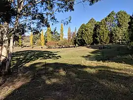
Tomboye is a locality in the Queanbeyan–Palerang Regional Council, New South Wales, Australia. It is located on the north side of the Mongarlowe River on the road from Braidwood to Nowra about 28 km north of Braidwood and 93 km southwest of Nowra.[2][3] At the 2016 census, it had a population of 40.[1] It consists mainly of forest and grazing country.
| Tomboye New South Wales | |||||||||||||||
|---|---|---|---|---|---|---|---|---|---|---|---|---|---|---|---|
 | |||||||||||||||
Tomboye Location in New South Wales | |||||||||||||||
| Coordinates | 35°14′57″S 149°58′02″E | ||||||||||||||
| Population | 40 (2016 census)[1] | ||||||||||||||
| Postcode(s) | 2622 | ||||||||||||||
| Location | |||||||||||||||
| LGA(s) | Queanbeyan-Palerang Regional Council | ||||||||||||||
| Region | Southern Tablelands | ||||||||||||||
| County | St Vincent | ||||||||||||||
| Parish | Tomboye | ||||||||||||||
| State electorate(s) | Monaro | ||||||||||||||
| Federal Division(s) | Eden-Monaro | ||||||||||||||
| |||||||||||||||
Tomboye had a "half-time" school from 1867 to 1879. Up to June 1893, it was called Jamboye school.[4]
References
- Australian Bureau of Statistics (27 June 2017). "Tomboye". 2016 Census QuickStats. Retrieved 27 April 2018.

- "Tomboye". Geographical Names Register (GNR) of NSW. Geographical Names Board of New South Wales. Retrieved 27 April 2018.
- "Tomboye". OpenStreetMap. Retrieved 27 April 2018.
- "Tomboye in the School history database search". New South Wales Department of Education. Retrieved 27 April 2018.
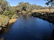
Mongarlowe River looking east with Tomboye on the left and Marlowe on the right
This article is issued from Wikipedia. The text is licensed under Creative Commons - Attribution - Sharealike. Additional terms may apply for the media files.