Crépey
Crépey is a commune in the Meurthe-et-Moselle department in north-eastern France.
Crépey | |
|---|---|
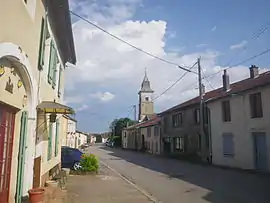 A view within Crépey | |
.svg.png.webp) Coat of arms | |
Location of Crépey 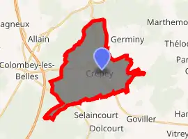
| |
 Crépey  Crépey | |
| Coordinates: 48°31′43″N 5°58′20″E | |
| Country | France |
| Region | Grand Est |
| Department | Meurthe-et-Moselle |
| Arrondissement | Toul |
| Canton | Meine au Saintois |
| Intercommunality | CC Pays de Colombey et Sud Toulois |
| Government | |
| • Mayor (2014–2020) | Andrée Rouyer |
| Area 1 | 20.9 km2 (8.1 sq mi) |
| Population (2017-01-01)[1] | 394 |
| • Density | 19/km2 (49/sq mi) |
| Time zone | UTC+01:00 (CET) |
| • Summer (DST) | UTC+02:00 (CEST) |
| INSEE/Postal code | 54143 /54170 |
| Elevation | 297–434 m (974–1,424 ft) (avg. 340 m or 1,120 ft) |
| 1 French Land Register data, which excludes lakes, ponds, glaciers > 1 km2 (0.386 sq mi or 247 acres) and river estuaries. | |
The altitude of the city hall of Crépey is approximately 340 meters. The Crépey surface is 20.90 km ². The latitude and longitude of Crépey are 48.528 degrees North and 5.973 degrees East.
Population and Housing
The population of Crépey was 272 in 1999, 326 in 2006 and 334 in 2007. The population density of Crépey is 15.98 inhabitants per km². The number of housing of Crépey was 148 in 2007. These homes of Crépey consist of 124 main residences, 14 second or occasional homes and 10 vacant homes. [2]
References
- "Populations légales 2017". INSEE. Retrieved 6 January 2020.
- "CREPEY - Map of Crépey 54170 France". www.map-france.com. Retrieved 2018-11-15.
| Wikimedia Commons has media related to Crépey. |
| Authority control |
|
|---|
This article is issued from Wikipedia. The text is licensed under Creative Commons - Attribution - Sharealike. Additional terms may apply for the media files.
