Bouillonville
Bouillonville is a commune in the Meurthe-et-Moselle department in northeastern France.
Bouillonville | |
|---|---|
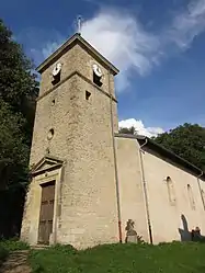 The church in Bouillonville | |
 Coat of arms | |
Location of Bouillonville 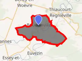
| |
 Bouillonville  Bouillonville | |
| Coordinates: 48°56′43″N 5°50′35″E | |
| Country | France |
| Region | Grand Est |
| Department | Meurthe-et-Moselle |
| Arrondissement | Toul |
| Canton | Le Nord-Toulois |
| Intercommunality | Trois Vallées |
| Government | |
| • Mayor (2008–2014) | Gérard Renouard |
| Area 1 | 5.32 km2 (2.05 sq mi) |
| Population (2017-01-01)[1] | 156 |
| • Density | 29/km2 (76/sq mi) |
| Time zone | UTC+01:00 (CET) |
| • Summer (DST) | UTC+02:00 (CEST) |
| INSEE/Postal code | 54087 /54470 |
| Elevation | 205–264 m (673–866 ft) (avg. 209 m or 686 ft) |
| 1 French Land Register data, which excludes lakes, ponds, glaciers > 1 km2 (0.386 sq mi or 247 acres) and river estuaries. | |
Geography
The village lies on the left bank of the Rupt de Mad, which flows north through the middle of the commune.
Population
| Year | Pop. | ±% |
|---|---|---|
| 1962 | 92 | — |
| 1968 | 102 | +10.9% |
| 1975 | 85 | −16.7% |
| 1982 | 76 | −10.6% |
| 1990 | 80 | +5.3% |
| 1999 | 91 | +13.7% |
| 2006 | 103 | +13.2% |
| 2009 | 121 | +17.5% |
Sights
- The German war cemetery, where rest 1,368 German soldiers from World War I.[2]
References
- "Populations légales 2017". INSEE. Retrieved 6 January 2020.
- "Seite nicht gefunden". www.ich-bin-gegen-gewalt.de. Retrieved 8 April 2018.
| Wikimedia Commons has media related to Bouillonville. |
| Authority control |
|---|
This article is issued from Wikipedia. The text is licensed under Creative Commons - Attribution - Sharealike. Additional terms may apply for the media files.
