Thiaucourt-Regniéville
Thiaucourt-Regniéville is a commune in the Meurthe-et-Moselle department in north-eastern France.
Thiaucourt-Regniéville | |
|---|---|
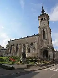 Church of Saint-Rémi | |
 Coat of arms | |
Location of Thiaucourt-Regniéville 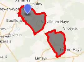
| |
 Thiaucourt-Regniéville  Thiaucourt-Regniéville | |
| Coordinates: 48°57′18″N 5°52′01″E | |
| Country | France |
| Region | Grand Est |
| Department | Meurthe-et-Moselle |
| Arrondissement | Toul |
| Canton | Le Nord-Toulois |
| Intercommunality | Mad et Moselle |
| Government | |
| • Mayor (2008–2014) | Jean-Louis Cossin |
| Area 1 | 19.01 km2 (7.34 sq mi) |
| Population (2017-01-01)[1] | 1,132 |
| • Density | 60/km2 (150/sq mi) |
| Time zone | UTC+01:00 (CET) |
| • Summer (DST) | UTC+02:00 (CEST) |
| INSEE/Postal code | 54518 /54470 |
| Elevation | 202–347 m (663–1,138 ft) (avg. 215 m or 705 ft) |
| 1 French Land Register data, which excludes lakes, ponds, glaciers > 1 km2 (0.386 sq mi or 247 acres) and river estuaries. | |
Geography
The Rupt de Mad flows northeastward through the north-western part of the commune and crosses the village.
Sights
- The St. Mihiel American Cemetery and Memorial
- The German war cemetery, where rest more than 11,000 German soldiers from World War I and some French soldiers.[2]
References
- "Populations légales 2017". INSEE. Retrieved 6 January 2020.
- "Archived copy". Archived from the original on 2011-07-18. Retrieved 2009-04-22.CS1 maint: archived copy as title (link)
| Wikimedia Commons has media related to Thiaucourt-Regniéville. |
| Authority control |
|
|---|
This article is issued from Wikipedia. The text is licensed under Creative Commons - Attribution - Sharealike. Additional terms may apply for the media files.