Mont-sur-Meurthe
Mont-sur-Meurthe is a commune in the Meurthe-et-Moselle department in north-eastern France.
Mont-sur-Meurthe | |
|---|---|
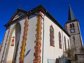 The church in Mont-sur-Meurthe | |
 Coat of arms | |
Location of Mont-sur-Meurthe 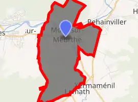
| |
 Mont-sur-Meurthe  Mont-sur-Meurthe | |
| Coordinates: 48°33′20″N 6°26′37″E | |
| Country | France |
| Region | Grand Est |
| Department | Meurthe-et-Moselle |
| Arrondissement | Lunéville |
| Canton | Lunéville-2 |
| Intercommunality | CC Meurthe, Mortagne, Moselle |
| Government | |
| • Mayor (2008–2014) | Yves Willer |
| Area 1 | 9.51 km2 (3.67 sq mi) |
| Population (2017-01-01)[1] | 1,114 |
| • Density | 120/km2 (300/sq mi) |
| Time zone | UTC+01:00 (CET) |
| • Summer (DST) | UTC+02:00 (CEST) |
| INSEE/Postal code | 54383 /54360 |
| Elevation | 216–277 m (709–909 ft) (avg. 230 m or 750 ft) |
| 1 French Land Register data, which excludes lakes, ponds, glaciers > 1 km2 (0.386 sq mi or 247 acres) and river estuaries. | |
Geography
The village lies in the middle of the commune, where the river Mortagne flows into the Meurthe.
References
- "Populations légales 2017". INSEE. Retrieved 6 January 2020.
| Wikimedia Commons has media related to Mont-sur-Meurthe. |
| Authority control |
|---|
This article is issued from Wikipedia. The text is licensed under Creative Commons - Attribution - Sharealike. Additional terms may apply for the media files.