Pierrepont, Meurthe-et-Moselle
Pierrepont is a commune in the Meurthe-et-Moselle department in north-eastern France.
Pierrepont | |
|---|---|
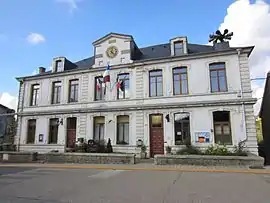 The town hall in Pierrepont | |
 Coat of arms | |
Location of Pierrepont 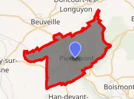
| |
 Pierrepont  Pierrepont | |
| Coordinates: 49°24′59″N 5°42′44″E | |
| Country | France |
| Region | Grand Est |
| Department | Meurthe-et-Moselle |
| Arrondissement | Briey |
| Canton | Mont-Saint-Martin |
| Intercommunality | CC Terre Lorraine du Longuyonnais |
| Government | |
| • Mayor (2008–2014) | Jean-Luc Schmitz |
| Area 1 | 7.02 km2 (2.71 sq mi) |
| Population (2017-01-01)[1] | 870 |
| • Density | 120/km2 (320/sq mi) |
| Time zone | UTC+01:00 (CET) |
| • Summer (DST) | UTC+02:00 (CEST) |
| INSEE/Postal code | 54428 /54620 |
| Elevation | 227–336 m (745–1,102 ft) (avg. 241 m or 791 ft) |
| 1 French Land Register data, which excludes lakes, ponds, glaciers > 1 km2 (0.386 sq mi or 247 acres) and river estuaries. | |
History
During the First World War was from 1915 to 1918 in Ugny was the artillery, in the forest of Doncourt the training ground and in Beuveille has been the headquarter of the Sturm-Bataillon Nr. 5 (Rohr), in Pierrepont has been the hospital and the cemetery.
On the German soldiers cemetery, the dead of the Battalion were mostly buried. The monument, in the shape of a lion guarding the dead, has already been set up during the war and then not eliminated.[2]
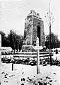 Memorial
Notes
- "Populations légales 2017". INSEE. Retrieved 6 January 2020.
- Eberhard Graf von Schwerin: Königlich preußisches Sturm-Bataillon Nr . 5 (Rohr) (Aus Deutschlands großer Zeit; Band 116) nach der Erinnerung aufgezeichnet unter Zuhilfenahme des Tagebuches von Oberstleutnant a. D. Willi Rohr / Graf v. Schwerin; Verlag Bernhard Sporn, Zeulenroda 1939
| Wikimedia Commons has media related to Pierrepont (Meurthe-et-Moselle). |
| Authority control |
|---|
This article is issued from Wikipedia. The text is licensed under Creative Commons - Attribution - Sharealike. Additional terms may apply for the media files.
