Mont-Bonvillers
Mont-Bonvillers is a commune in the Meurthe-et-Moselle department in north-eastern France.[2] It is a small area in France.
Mont-Bonvillers | |
|---|---|
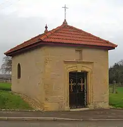 The chapel in Mont-Bonvillers | |
.svg.png.webp) Coat of arms | |
Location of Mont-Bonvillers 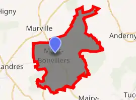
| |
 Mont-Bonvillers  Mont-Bonvillers | |
| Coordinates: 49°19′39″N 5°50′09″E | |
| Country | France |
| Region | Grand Est |
| Department | Meurthe-et-Moselle |
| Arrondissement | Briey |
| Canton | Pays de Briey |
| Intercommunality | Cœur du Pays-Haut |
| Government | |
| • Mayor (2008–2014) | Robert Clesse |
| Area 1 | 7.44 km2 (2.87 sq mi) |
| Population (2017-01-01)[1] | 948 |
| • Density | 130/km2 (330/sq mi) |
| Time zone | UTC+01:00 (CET) |
| • Summer (DST) | UTC+02:00 (CEST) |
| INSEE/Postal code | 54084 /54111 |
| Elevation | 270–361 m (886–1,184 ft) (avg. 325 m or 1,066 ft) |
| 1 French Land Register data, which excludes lakes, ponds, glaciers > 1 km2 (0.386 sq mi or 247 acres) and river estuaries. | |
See also
| Wikimedia Commons has media related to Mont-Bonvillers. |
References
- "Populations légales 2017". INSEE. Retrieved 6 January 2020.
- "Accueil". www.mont-bonvillers.mairie54.fr. Retrieved 2016-12-09.
| Authority control |
|
|---|
This article is issued from Wikipedia. The text is licensed under Creative Commons - Attribution - Sharealike. Additional terms may apply for the media files.
