Saint-Max
Saint-Max is a commune in the Meurthe-et-Moselle department in north-eastern France.
Saint-Max | |
|---|---|
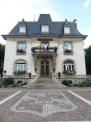 Saint-Max City Hall | |
 Coat of arms | |
Location of Saint-Max 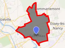
| |
 Saint-Max  Saint-Max | |
| Coordinates: 48°42′06″N 6°12′26″E | |
| Country | France |
| Region | Grand Est |
| Department | Meurthe-et-Moselle |
| Arrondissement | Nancy |
| Canton | Saint-Max |
| Intercommunality | Métropole du Grand Nancy |
| Government | |
| • Mayor (2008–2014) | Eric Pensalfini |
| Area 1 | 1.85 km2 (0.71 sq mi) |
| Population | 9,965 |
| • Density | 5,400/km2 (14,000/sq mi) |
| Time zone | UTC+01:00 (CET) |
| • Summer (DST) | UTC+02:00 (CEST) |
| INSEE/Postal code | 54482 /54130 |
| Elevation | 193–342 m (633–1,122 ft) |
| 1 French Land Register data, which excludes lakes, ponds, glaciers > 1 km2 (0.386 sq mi or 247 acres) and river estuaries. | |
Geography [2]
The city of Saint-Max is located in north-eastern France, a suburb of Nancy. The surrounding communities are: Nancy, Essey-les-Nancy, Tomblaine, Dommartemont and Malzéville. Since 1996, it is part of the Urban Community of Greater Nancy alongside 19 other municipalities.
Places and Monuments[3]
The Chateau du Pont de Meurthe is a beautiful large mansion of Napoleon III that completed in 1874. One can admire, among others, a beautiful stone staircase with a wrought iron railing and a carved wood fireplace. By 1955, it became the property of the city and has hosted successive CREPS, college, general education, a physical rehabilitation centre school. In 1976, the library moved there. In 1990, it was the turn of the school music.
References
- "Populations légales 2017". INSEE. Retrieved 6 January 2020.
- Wikipedia"
- Wikipedia"
| Wikimedia Commons has media related to Saint-Max. |
| Authority control |
|---|
