Dabeiba
Dabeiba (Spanish pronunciation: [daˈβejβa]) is a town and municipality in the Colombian department of Antioquia. The Battle of Dabeiba took place there in October 2000.[2]
Dabeiba | |
|---|---|
Municipality and town | |
 Bold t§ext | |
.svg.png.webp) Flag  Seal | |
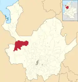 Location of the municipality and town of Dabeiba in the Antioquia Department of Colombia | |
 Dabeiba Location in Colombia | |
| Coordinates: 7°0′5″N 76°15′40″W | |
| Country | |
| Department | |
| Subregion | Western |
| Area | |
| • Total | 1,883 km2 (727 sq mi) |
| Elevation | 450 m (1,480 ft) |
| Population (Census 2018[1]) | |
| • Total | 22,717 |
| • Density | 12/km2 (31/sq mi) |
| Time zone | UTC-5 (Colombia Standard Time) |
Climate
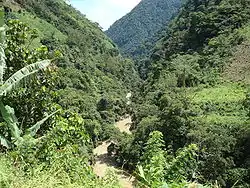
Dabeiba has a tropical rainforest climate (Af) with heavy rainfall year-round.
| Climate data for Dabeiba | |||||||||||||
|---|---|---|---|---|---|---|---|---|---|---|---|---|---|
| Month | Jan | Feb | Mar | Apr | May | Jun | Jul | Aug | Sep | Oct | Nov | Dec | Year |
| Average high °C (°F) | 31.5 (88.7) |
31.6 (88.9) |
32.1 (89.8) |
31.5 (88.7) |
30.4 (86.7) |
30.6 (87.1) |
30.7 (87.3) |
30.7 (87.3) |
29.9 (85.8) |
29.8 (85.6) |
29.8 (85.6) |
30.3 (86.5) |
30.7 (87.3) |
| Daily mean °C (°F) | 25.7 (78.3) |
26.1 (79.0) |
26.6 (79.9) |
26.1 (79.0) |
25.6 (78.1) |
25.6 (78.1) |
25.6 (78.1) |
25.7 (78.3) |
25.2 (77.4) |
25.1 (77.2) |
25.1 (77.2) |
25.3 (77.5) |
25.6 (78.2) |
| Average low °C (°F) | 20.0 (68.0) |
20.6 (69.1) |
21.1 (70.0) |
20.8 (69.4) |
20.8 (69.4) |
20.6 (69.1) |
20.6 (69.1) |
20.7 (69.3) |
20.6 (69.1) |
20.5 (68.9) |
20.5 (68.9) |
20.4 (68.7) |
20.6 (69.1) |
| Average rainfall mm (inches) | 95 (3.7) |
91 (3.6) |
108 (4.3) |
274 (10.8) |
342 (13.5) |
331 (13.0) |
319 (12.6) |
359 (14.1) |
349 (13.7) |
385 (15.2) |
299 (11.8) |
209 (8.2) |
3,161 (124.5) |
| Source: Climate-Data.org[3] | |||||||||||||
References
- "Censo Nacional de Población y Vivienda 2018" (in Spanish). Retrieved 23 April 2020.
- Dozens die in Colombia battle
- "Climate: Dabeiba". Climate-Data.org. Retrieved August 30, 2020.
This article is issued from Wikipedia. The text is licensed under Creative Commons - Attribution - Sharealike. Additional terms may apply for the media files.