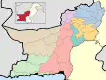
Districts of Balochistan, Pakistan
The province of Balochistan, the least populated province of Pakistan and the largest province by area, is divided into 33 districts and seven divisions. Below, you will find an overview of the recent history of districts in Balochistan, Pakistan, a map showing each district, the divisions of Balochistan and their districts, and a list showing each district's name, the division the district belongs to, the district's area, the location of the district's headquarters, the district's population and population density (in 2017), the average annual population growth rate of each district (between 1998 and 2017), and a map showing each district's location.
| Districts of Balochistan, Pakistan | |
|---|---|
 | |
| Location | Balochistan, Pakistan |
| Number | 33 (as of September 30, 2020) |
| Populations | 97,017 (Harnai District) – 2,275,699 (Quetta District) |
| Government | District Government City District Government Zilla Council |
| Subdivisions | Tehsils |
History
1877 - 1901
The area which covers the modern-day Pakistani province of Balochistan was first introduced to districts and divisions as administrative units under the British, and the area was first incorporated into British India in 1877. The first census of the Balochistan region was held in 1891, but it only covered the parts of Balochistan east of the 66th meridian east, was incomplete, and never had a report written about it.[1] The first full census that was completed and had a report written on it took place in 1901. By 1901, Balochistan was divided into both the Baluchistan Agency and the Chief Commissioner's Province of Baluchistan, which was also more commonly known as British Baluchistan.
In 1901, British Baluchistan consisted principally of the areas which were under the control of Afghans, but were ceded to the British with the Treaty of Gandamak in 1879, and were formally declared British India in 1887. It was divided into two districts: Thal-Chotiali District, which consisted of the Tehsils of Duki, Shahrig (Shahrug), and Sibi, and Quetta-Pishin District, which was subdivided into Pishin Tehsil, Chaman Subdivision, and Shorarud Sub-Division.[1]
The Baluchistan Agency was split into three divisions: The areas directly administered by the British, the Native States, and the Tribal Areas.[1]
The areas directly administered by the British consisted of the Bolan Agency, the Chagai Agency (which consisted of Chagai, Nushki, and Western Sinjrani), the Quetta-Pishin Agency (which consisted of Quetta Tehsil excluding Shorarud), the Thal-Chotiali Agency (made of the Barkhan Tehsil, the Kohlu Sub-Tehsil, and the Sanjawi (Sinjawi) Sub-Tehsil), and the Zhob Agency (which included Fort Sandeman, Hindobagh, Loralai, Musakhel, and Qilla Saifullah Tehsils).[1]
There were four autonomous princely states, making up the native states, in Balochistan: The state of Kharan (which was a vassal of Qalat), The state of Las Bela, The state of Makran, and the Khanate of Qalat (which was divided into Domki, Kaheri, and Umrani Country; Jhalawan Country; Kachhi Country; Nasirabad Niabat; and Sarawan Country).[1]
The two tribal areas were Bugti Country and Marri Country. The tribal areas consisted of Baloch tribes which, as per the census report of 1901, exhibited "nomadic tendency to the largest degree".[1]
This meant that the administrative setup of the Balochistan region under British control was as follows in 1901 (territories which do not exist anymore are in red writing, territories which have been renamed or have had a status change (from princely state to district, for example) are in blue writing):[1]
- British Baluchistan
- Quetta-Pishin District
- Thal-Chotiali District
- Baluchistan Agency
- Directly Administered Territories
- Bolan Agency
- Chagai Agency
- Quetta-Pishin Agency
- Thal-Chotiali Agency
- Zhob Agency
- Native Princely States
- State of Kharan
- State of Las Bela
- State of Makran
- Khanate of Qalat
- Tribal Areas
- Bugti Country
- Marri Country
- Directly Administered Territories
1901 - 1947
By the time of the 1911 census, all the directly administered territories of the Baluchistan Agency had been abolished and reformed into districts in the Chief Commissioner's Province (British Baluchistan). Thal-Chotiali District was also abolished. In their place came the six districts of Bolan (previously Bolan Agency), Chagai (previously Chagai Agency), Loralai (previously parts of Thal-Chotiali District and Thal-Chotiali Agency), Quetta-Pishin (previously Quetta-Pishin District and Quetta-Pishin Agency), Sibi (previously parts of Thal-Chotiali District and Thal-Chotiali Agency), and Zhob (previously Zhob Agency). The two Tribal Areas of Bugti Country and Marri Country were also abolished as a separate unit and were made a part of Sibi District called Marri-Bugti Country (which became known the unadministered area of Sibi District, as opposed to the administered areas which covered parts of Thal-Chotiali District and Thal-Chotiali Agency).[2]
No changes occurred to the administrative setup of the Native Princely States, which now made up the entire Baluchistan Agency until 1940, when the State of Kharan gained complete independence from the Khanate of Qalat. This did not, though, have any affect on the borders and administrative units of the borders themselves, as the State of Kharan already existed as an entity before. The only difference was now it was completely separate from Qalat.[3]
This left the following administrative setup, which would see no changes through the 1921,[4] 1931,[5] and 1941 censuses,[3] all the way until Pakistani independence (territories which do not exist anymore are in red writing, territories which have been renamed or have had a status change (from princely state to district, for example) are in blue writing):[2][4][5]
- British Baluchistan
- Bolan District
- Chagai District
- Loralai District
- Quetta-Pishin District
- Sibi District
- Administered Area
- Marri-Bugti Country
- Zhob District
- Baluchistan Agency
- State of Kharan
- State of Las Bela
- State of Makran
- Khanate of Qalat
1998 - 2017
At the time of the 1998 Census of Pakistan, Balochistan had 26 districts,[6] but since then, the province has created 7 brand new districts.
In 2005, the tehsil of Washuk received district status after splitting off from the district of Kharan, and became Washuk District. [7] [8]
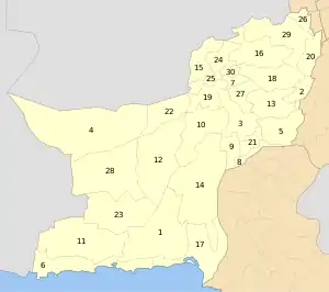
Current Map
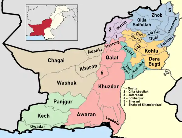
list of districts
| Map | Sr. No. | District | Headquarters | Area (km2) | Population (1998) | Population (2017) | Density (people/km2) |
 |
1 | Awaran | Awaran | 12,510 | 118,173 | 121,680 | 4 |
| 2 | Barkhan | Barkhan | 3,514 | 103,545 | 171,556 | 29 | |
| 3 | Kachhi (Bolan) | Dhadar | 7,499 | 288,056 | 237,030 | 38 | |
| 4 | Chagai | Chagai | 44,748[9] | 300,000 | 7 | ||
| 5 | Dera Bugti | Dera Bugti | 10,160 | 181,310 | 18 | ||
| 6 | Gwadar | Gwadar | 12,637 | 185,498 | 15 | ||
| 7 | Harnai[10][note 1] | Harnai | 4,096 | 140,000 | 19 | ||
| 8 | Jafarabad | Dera Allahyar | 2,445 | 432,817 | 177 | ||
| 9 | Jhal Magsi | Jhal Magsi | 3,615 | 109,941 | 30 | ||
| 10 | Kalat | Kalat | 6,622 | 237,834 | 36 | ||
| 11 | Kech (Turbat) | Turbat | 22,539 | 413,204 | 911000 | 18 | |
| 12 | Kharan | Kharan | 18958 | 96900 | 156,152 | 4 | |
| 13 | Kohlu | Kohlu | 7,610 | 99,846 | 214,805 | 13 | |
| 14 | Khuzdar | Khuzdar | 35,380 | 417,466 | 12 | ||
| 15 | Killa Abdullah | Chaman | 3,293 | 370,269 | 112 | ||
| 16 | Killa Saifullah | Killa Saifullah | 6,831 | 193,553 | 28 | ||
| 17 | Lasbela | Uthal | 15,153 | 312,695 | 21 | ||
| 18 | Loralai | Loralai | 9,830 | 295,555 | 30 | ||
| 19 | Mastung | Mastung | 5,896 | 179,784 | 30 | ||
| 20 | Musakhel | Musa Khel Bazar | 5,728 | 134,056 | 23 | ||
| 21 | Nasirabad | Dera Murad Jamali | 3,387 | 245,894 | 73 | ||
| 22 | Nushki[11] | Nushki | 5,797 | 137,500 | 23 | ||
| 23 | Panjgur | Panjgur | 16,891 | 234,051 | 14 | ||
| 24 | Pishin | Pishin | 7,819 | 367,183 | 47 | ||
| 25 | Quetta | Quetta | 2,653 | 744,802 | 281 | ||
| 26 | Sherani[note 2] | Sherani | |||||
| 27 | Sibi | Sibi | 7,796 | 180,398 | 23 | ||
| 28 | Washuk[note 3] | Washuk | 29,510 | 118,171 | 4.0 | ||
| 29 | Zhob | Zhob | 20,297 | 275,142 | 14 | ||
| 30 | Ziarat | Ziarat | 1,489 | 33,340 | 22 | ||
| (31) | Lehri (not on the map) | Lehri | 9,830 | 295,555 | 30 | ||
| (32) | Sohbatpur (not on the map) | Sohbatpur | 7,796 | 180,398 | 23 | ||
| (33) | Duki (not on the map) | Duki | |||||
| (34) | Shaheed Sikandarabad (not on the map) | Surab | |||||
Notes
- No data is yet available on the recently created district of Harnai, which was part of Sibi district.
- No data is yet available on the recently created district of Sherani, which was part of Zhob district.
- No data is yet available on the recently created district of Washuk, which was part of Kharan district.
References
- "Census of India 1901. Vol. 5, Baluchistan. Pt. 1, Report". Census of India 1901. Vol. 5, Baluchistan. Pt. 1, Report. on JSTOR. Centre for Studies in Social Sciences, Calcutta. 1902. Archived from the original on 6 July 2020. Retrieved 19 October 2020.
- "Census of India 1911. Vol. 4, Baluchistan : pt. 1, Report; pt. 2, Tables". Census of India 1911. Vol. 4, Baluchistan : pt. 1, Report; pt. 2, Tables. on JSTOR. Centre for Studies in Social Sciences, Calcutta. 1913. Archived from the original on 14 November 2020. Retrieved 14 November 2020.
- "Census of India, 1941. Vol. 14, Baluchistan". Census of India, 1941. Vol. 14, Baluchistan on JSTOR. Centre for Studies in Social Sciences, Calcutta. 1942. Archived from the original on 14 November 2020. Retrieved 14 November 2020.
- "Census of India 1921. Vol. 4, Baluchistan : part I, Report; part II, Tables". Census of India 1921. Vol. 4, Baluchistan : part I, Report; part II, Tables. on JSTOR. Centre for Studies in Social Sciences, Calcutta. 1923. Archived from the original on 14 November 2020. Retrieved 14 November 2020.
- "Census of India 1931. Vol. 4, Baluchistan. Pts. 1 & 2, Report [and] Imperial and provincial tables". Census of India 1931. Vol. 4, Baluchistan. Pts. 1 & 2, Report [and] Imperial and provincial tables. on JSTOR. Centre for Studies in Social Sciences, Calcutta. 1934. Archived from the original on 14 November 2020. Retrieved 14 November 2020.
- "Balochistan". Balochistan | Pakistan Bureau of Statistics. Pakistan Bureau of Statistics. Archived from the original on 18 August 2020. Retrieved 18 August 2020.
- "Washuk District Profile" (PDF). District-Washuk-Profile.pdf. RSPN. April 2018. Archived (PDF) from the original on 18 August 2020. Retrieved 18 August 2020.
- "Washuk District Education Plan (2016-17 to 2020-21)" (PDF). WASHUK DISTRICT EDUCATION PLAN FOR 2016-2017 TO 2020-2021.pdf. Balochistan EMIS. 18 February 2016. Archived (PDF) from the original on 18 August 2020. Retrieved 18 August 2020.
- "Country escapes major earthquake damage". Daily Times. 20 January 2011. Archived from the original on 11 December 2013. Retrieved 16 February 2014.
- "Harnai is new district of Balochistan". Dawn.Com. 31 August 2007. Retrieved 16 February 2014.
- "Kharan and Noshki District" (PDF). American Refugee Committee. July 2007. Archived from the original (PDF) on 2011-07-25. Retrieved 16 February 2014.
Pakistan articles | |||||||||||||||||||
|---|---|---|---|---|---|---|---|---|---|---|---|---|---|---|---|---|---|---|---|
| |||||||||||||||||||
| |||||||||||||||||||
| |||||||||||||||||||
| |||||||||||||||||||
| |||||||||||||||||||
| |||||||||||||||||||