Frankfort Township, Will County, Illinois
Frankfort Township is one of 24 townships in Will County, Illinois. As of the 2010 census, its population was 57,055 and it contained 19,720 housing units.[2]
Frankfort Township | |
|---|---|
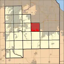 Location in Will County | |
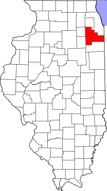 Will County's location in Illinois | |
| Coordinates: 41°30′42″N 87°51′09″W | |
| Country | United States |
| State | Illinois |
| County | Will |
| Established | November 6, 1849 |
| Government | |
| • Supervisor | Jim Moustis |
| Area | |
| • Total | 36.83 sq mi (95.39 km2) |
| • Land | 36.8 sq mi (95.31 km2) |
| • Water | 0.03 sq mi (0.08 km2) 0.08% |
| Elevation | 387 ft (118 m) |
| Population (2010) | |
| • Estimate (2016)[1] | 59,278 |
| • Density | 1,550.3/sq mi (598.6/km2) |
| Time zone | UTC-6 (CST) |
| • Summer (DST) | UTC-5 (CDT) |
| ZIP codes | 60423, 60448, 60467, 60477, 60487 |
| Area code(s) | 708, 779, 815 |
| FIPS code | 17-197-27631 |
| Website | www |
Geography
According to the 2010 census, the township has a total area of 36.83 square miles (95.4 km2), of which 36.8 square miles (95 km2) (or 99.92%) is land and 0.03 square miles (0.078 km2) (or 0.08%) is water.[2] It includes almost all of Frankfort and Mokena as well as small portions of Tinley Park and Orland Park.
Boundaries
Frankfort Township is bordered by Harlem Avenue (Illinois Route 43) on the east (where Cook County and Will County share a border), 183rd Street and Orland Parkway on the north (which is also the Cook-Will county border), Townline Road on the west, and Steger Road on the south.
Cities, towns, villages
- Frankfort (vast majority)
- Mokena (vast majority)
- Tinley Park (small portion)
- Orland Park (small portion)
Adjacent townships
- Orland Township, Cook County (north)
- Bremen Township, Cook County (northeast)
- Rich Township, Cook County (east)
- Monee Township (southeast)
- Green Garden Township (south)
- Manhattan Township (southwest)
- New Lenox Township (west)
- Homer Township (northwest)
Cemeteries
The township contains these eight cemeteries: Frankfort Township, Frankfort, Pioneer Memorial, Pleasant Hill, Saint John's United Church of Christ, Saint Mary's, Stellwagen, and Union Burial Society.
Major highways
Lakes
- Gun Club Lake
Landmarks
- Hunters Woods County Forest Preserve
- Hickory Creek Preserve (east three-quarters)
Political districts
- Illinois' 1st congressional district
- State House District 37
- State House District 38
- State House District 80
- State Senate District 19
- State Senate District 40
References
- "Population and Housing Unit Estimates". Retrieved June 9, 2017.
- "Population, Housing Units, Area, and Density: 2010 - County -- County Subdivision and Place -- 2010 Census Summary File 1". United States Census. Archived from the original on 2020-02-12. Retrieved 2013-05-28.
- "Census of Population and Housing". Census.gov. Retrieved June 4, 2016.
External links
- Frankfort Township official website
- City-data.com
- Illinois State Archives
- Township Officials of Illinois
- Will County official site
Municipalities and communities of Will County, Illinois, United States | ||
|---|---|---|
| Cities | Map of Illinois highlighting Will County | |
| Villages |
| |
| CDPs | ||
| Townships | ||
| Unincorporated communities |
| |
| Ghost town | ||
| Footnotes | ‡This populated place also has portions in an adjacent county or counties | |
| ||