University Park, Illinois
University Park is a village south of Chicago mostly in Will County with a small portion in Cook County in the U.S. state of Illinois. It is the only predominantly African-American community in Will County. The village, one of the region's few planned communities, was developed in the 1960s as Wood Hill, then Park Forest South, and finally University Park. Governors State University was established in the village in 1969.[4] The village population was 7,129 at the 2010 census.[3]
University Park | |
|---|---|
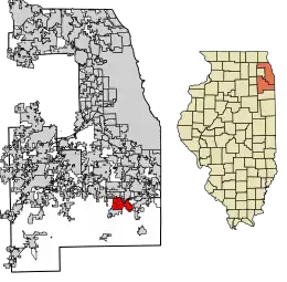 Location of University Park in Will County and Cook County, Illinois. | |
| Coordinates: 41°26′22″N 87°41′50″W | |
| Country | |
| State | Illinois |
| Counties | Cook, Will |
| Townships | Monee, Crete, Rich |
| Incorporated | 1967 |
| Government | |
| • Type | Council–manager |
| • Mayor | Joseph E. Roudez III |
| Area | |
| • Total | 10.73 sq mi (27.80 km2) |
| • Land | 10.73 sq mi (27.80 km2) |
| • Water | 0.00 sq mi (0.01 km2) 0% |
| Population (2010) | |
| • Total | 7,129 |
| • Estimate (2019)[2] | 6,887 |
| • Density | 641.73/sq mi (247.77/km2) |
| Up 7.01% from 2000 | |
| Standard of living (2007–11) | |
| • Per capita income | $20,083 |
| • Median home value | $49,400 |
| ZIP code(s) | 60484, 60478 |
| Area code(s) | 708 |
| Geocode | 76935 |
| FIPS code | 17-76935 |
| Website | university-park-il |
| Demographics (2010)[3] | |||
|---|---|---|---|
| White | Black | Asian | |
| Islander | Native | Other | Hispanic (any race) |
History
In the late 1950s, Woodhill Enterprises purchased land south of Park Forest for a large subdivision. Building began in 1961, but by 1967 Wood Hill had only 240 homes. Residents created a homeowners association, which fostered a community identity.[5]
In 1966, Nathan Manilow, one of the developers of Park Forest, started to purchase land around Wood Hill. Park Forest had been a model for planning in the 1940s, and Lewis Manilow, son of Nathan, formed New Community Enterprises (NCE) to build "a whole new town". Major partners included Illinois Central Industries and United States Gypsum Company.[5]
NCE supported the incorporation of Park Forest South in 1967 with projections for 100,000 residents. Under the federal New Communities Act of 1968, Park Forest South was designated as one of 15 such "new communities". Planning included space for residential, commercial, and industrial development and addressed the needs of education, recreation, and faith communities. Racial integration was a goal from the beginning, and Park Forest South became a leader in support of open housing.[5]
Governors State University opened its doors in 1969.[4] The Illinois Central Railroad made its first commuter extension in 40 years there. As a result, it is the last stop on the Metra Electric District line.[6][7] The city's initial plan included wooded preserves and recreation areas, building on recreation area set-asides and major land donations by the Manilow organization.[5]
The creativity and energy of the developers and village leadership led to great hopes for their "whole new town". In 1970, the state of Illinois allocated $24 million for the GSU campus. In 1971, HUD guaranteed $30 million in loans to bring the vision to reality.[5]
The developers modernized the water and sewage treatment facilities and in 1970 initiated the first elementary school, the first apartment complex, and Governors Gateway Industrial Park.[5]
However, difficulties arose in the economy, in the requirements and lack of resources from HUD, in the projections for growth, and in other areas, leading to suspended development in late 1974. For over two years, intense activity at public and private levels untangled many of the problems. The new town, intended for 100,000, adapted to a slow-growth plan anticipating an eventual 20,000 to 25,000 residents. The 2000 population, however, was 6,662, up slightly from the previous decade.[5]
New town planning remains evident. The industrial park next to Interstate 57 is integral to the village, and residential areas continue to offer open space, bikeways, and additional development. The new town heritage includes the Nathan Manilow Sculpture Park, a monumental internationally recognized outdoor sculpture park at GSU developed by Lewis Manilow to honor his father.[5]
Notable people
- Shonda Rhimes, television producer, screenwriter, and creator, head writer and executive producer of hit television series Grey's Anatomy, Private Practice, Scandal and How to Get Away With Murder, resided in University Park (formerly Park Forest South) as a child.
Geography
University Park is located at 41°26′22″N 87°41′50″W (41.439460, -87.697299).[8]
According to the 2010 census, University Park has a total area of 10.842 square miles (28.08 km2), of which 10.84 square miles (28.08 km2) (or 99.98%) is land and 0.002 square miles (0.01 km2) (or 0.02%) is water.[9] The village lies on the Valparaiso Moraine, which is also the Eastern Continental Divide.
Demographics
| Historical population | |||
|---|---|---|---|
| Census | Pop. | %± | |
| 1970 | 1,748 | — | |
| 1980 | 6,245 | 257.3% | |
| 1990 | 6,204 | −0.7% | |
| 2000 | 6,662 | 7.4% | |
| 2010 | 7,129 | 7.0% | |
| 2019 (est.) | 6,887 | [2] | −3.4% |
| U.S. Decennial Census[10] | |||
As of the census of 2010, there were 7,129 people, 2,416 households, and 1,772 families residing in the village. The population density was 657.7 people per square mile (253.9/km2). There were 2,730 housing units at an average density of 251.8 per square mile (97.2/km2). The racial makeup of the village was 6.1% White, 90.0% African American, 0.1% American Indian or Alaska Native, 0.8% Asian, 0.01% Native Hawaiian or Pacific Islander, 0.7% some other race, and 2.5% from two or more races. Hispanic or Latino of any race were 2.5% of the population.[3]
There were 2,416 households, out of which 49.3% had children under the age of 18 living with them, 33.9% were headed by married couples living together, 33.0% had a female householder with no husband present, and 26.7% were non-families. 22.7% of all households were made up of individuals, and 5.4% were someone living alone who was 65 years of age or older. The average household size was 2.94, and the average family size was 3.45.[3]
In the village, the population was spread out, with 33.8% under the age of 18, 9.5% from 18 to 24, 27.8% from 25 to 44, 22.2% from 45 to 64, and 6.8% who were 65 years of age or older. The median age was 30.1 years. For every 100 females there were 80.9 males. For every 100 females age 18 and over, there were 73.5 males.[3]
For the period 2007–11, the estimated median annual income for a household in the village was $49,133, and the median income for a family was $55,237. Male full-time workers had a median income of $46,901 versus $36,154 for females. The per capita income for the village was $20,083. About 19.0% of families and 19.6% of the population were below the poverty line, including 25.6% of those under age 18 and 18.7% of those age 65 or over.[11]
Government
University Park is in the Second Congressional District.
References
- "2019 U.S. Gazetteer Files". United States Census Bureau. Retrieved July 14, 2020.
- "Population and Housing Unit Estimates". United States Census Bureau. May 24, 2020. Retrieved May 27, 2020.
- "Profile of General Population and Housing Characteristics: 2010 Demographic Profile Data (DP-1): University Park village, Illinois". U.S. Census Bureau, American Factfinder. Archived from the original on February 12, 2020. Retrieved March 20, 2013.
- Fenton, Sarah. "Governors State University". The Encyclopedia of Chicago.
- McClellan, Larry A. "University Park". The Encyclopedia of Chicago.
- Leroux, Charles (September 1, 2006). "Metra service part of University Park plan". Chicago Tribune.
- "Metra Electric District Line".
- "US Gazetteer files: 2010, 2000, and 1990". United States Census Bureau. 2011-02-12. Retrieved 2011-04-23.
- "G001 – Geographic Identifiers – 2010 Census Summary File 1". United States Census Bureau. Archived from the original on 2020-02-13. Retrieved 2015-12-25.
- "Census of Population and Housing". Census.gov. Retrieved June 4, 2015.
- "Selected Economic Characteristics: 2007–2011 American Community Survey 5-Year Estimates (DP03): University Park village, Illinois". U.S. Census Bureau, American Factfinder. Archived from the original on February 10, 2020. Retrieved March 20, 2013.
Further reading
External links
| Wikimedia Commons has media related to University Park, Illinois. |
Municipalities and communities of Will County, Illinois, United States | ||
|---|---|---|
| Cities | Map of Illinois highlighting Will County | |
| Villages |
| |
| CDPs | ||
| Townships | ||
| Unincorporated communities |
| |
| Ghost town | ||
| Footnotes | ‡This populated place also has portions in an adjacent county or counties | |
| ||
| Major city |  | |
|---|---|---|
| Cities (over 30,000 in 2010) | ||
| Towns and villages (over 30,000 in 2010) |
| |
| Counties | ||
| Regions | ||
| Sub-regions | ||