Gagetown Parish, New Brunswick
Gagetown is a civil parish in Queens County, New Brunswick, Canada.[2]
Gagetown | |
|---|---|
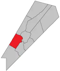 Location within Queens County, New Brunswick. | |
| Country | |
| Province | |
| County | Queens County |
| Erected | 1786 |
| Area | |
| • Land | 234.88 km2 (90.69 sq mi) |
| Population (2016)[1] | |
| • Total | 311 |
| • Density | 1.3/km2 (3/sq mi) |
| • Pop 2011-2016 | |
| • Dwellings | 155 |
| Time zone | UTC-4 (AST) |
| • Summer (DST) | UTC-3 (ADT) |
For governance purposes it is divided between CFB Gagetown, the village of Gagetown and the local service district of Upper Gagetown,[3] the latter two of which are members of Regional Service Commission 11 (RSC11).[4]
Origin of name
The original township was named in honour of General Thomas Gage, British Commander-in-Chief, North America at the time; he was principal grantee of the township.[5]
History
Gagetown was created in 1765 as Gage Township in Nova Scotia.
In 1786 the township formed the core of Gagetown Parish when New Brunswick erected its counties and parishes.[6] The parish added territory back to the Charlotte County line.[7][8]
In 1838 the rear of Gagetown was included in the newly erected Petersville Parish.[9]
Delineation
Gagetown Parish is defined in the Territorial Division Act[2] as being bounded:
- Northwest by the County line; southwest by Petersville Parish; northeast by the Saint John River; south and southeast by a line beginning on the western shore of the Saint John River at the northeast angle of lot number thirty-seven, granted to George Sweet; thence westerly along the northwest angle of same; thence south fifty-two degrees west, or to the southeast angle of lot number twenty-five, granted to T.T. Hewlett, on the northwestern side of the Gagetown Road,[lower-alpha 1] including Grimross Island.
Communities
Parish population total does not include incorporated municipalities (in bold).
|
|
Bodies of water & Islands
This is a list of rivers, lakes, streams, creeks, marshes and Islands that are at least partially in this parish
Demographics
Access Routes
Highways and numbered routes that run through the parish, including external routes that start or finish at the parish limits:[12]
|
|
|
|
See also
Notes
- Road is within CFB Gagetown and no longer appears on provincial road maps. Cadastral maps label it the Lawfield Road.
References
- "Census Profile, 2016 Census: Gagetown, Parish [Census subdivision], New Brunswick". Statistics Canada. Retrieved August 26, 2019.
- "Chapter T-3 Territorial Division Act". Government of New Brunswick. Retrieved 13 November 2020.
- "New Brunswick Regulation 84-168 under the Municipalities Act (O.C. 84-582)". Government of New Brunswick. Retrieved 19 July 2020.
- "Communities in each of the 12 Regional Service Commissions (RSC) / Les communautés dans chacune des 12 Commissions de services régionaux (CSR)" (PDF), Government of New Brunswick, July 2017, retrieved 2 February 2021
- Ganong, William F. (1896). A Monograph of the Place-Nomenclature of the Province of New Brunswick. Royal Society of Canada. p. 235.
- "26 Geo. III Chapter I. An Act for the better ascertaining and confirming the Boundaries of the several Counties within this Province, and for subdividing them into Towns or Parishes.". Acts of the General Assembly of His Majesty's Province of New-Brunswick, passed in the year 1786. Saint John, New Brunswick: Government of New Brunswick. 1786. pp. 3–12.
- A Monograph of the Evolution of the Boundaries of the Province of New Brunswick. Royal Society of Canada. 1901. p. 431.
- Ganong, Evolution, Map No. 35 (between pages 414 and 415)
- "1 Vic. c. 35 An Act to erect a part of the Parishes of Gagetown and Hampstead, in Queen's County, into a separate and distinct Town or Parish.". Acts of the General Assembly of Her Majesty's Province of New Brunswick, Passed in the Year 1838. Fredericton: Government of New Brunswick. 1838. p. 78.
- Statistics Canada: 2001, 2006 census
- 2011 Statistics Canada Census Profile: Gagetown Parish, New Brunswick
- Atlantic Canada Back Road Atlas ISBN 978-1-55368-618-7
Places adjacent to Gagetown Parish, New Brunswick | |
|---|---|
| Subdivisions | |
|---|---|
| Cities | |
| Counties | |
| |
