Geography of Wisconsin
Wisconsin is a state in the Midwestern United States. It has a vast and diverse geography famous for its landforms caused by glaciers during the ice age 17 thousand years ago. The southwestern part of the state is called the Driftless Area, as it was not covered by glaciers during the most recent ice age, the Wisconsin Glaciation.[1] This is responsible for the formation of the Wisconsin Dells, Devil's Lake, and the Baraboo Range.

Wisconsin is bordered by the Montreal River; Lake Superior and Michigan to the north; by Lake Michigan to the east; by Illinois to the south; and by Iowa to the southwest and Minnesota to the northwest. A border dispute with Michigan was settled by two cases, both Wisconsin v. Michigan, in 1934 and 1935. The state's boundaries include the Mississippi River and St. Croix River in the west, and the Menominee River in the northeast.

The pole of inaccessibility for Wisconsin, located approximately 15 miles (24 km) southwest of Wausau at 44.8824°N 89.912°W, marks the location furthest from any point not within Wisconsin (94.24 mi or 151.66 km).
Climate
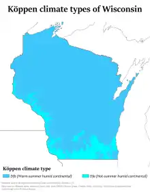
Most of Wisconsin is classified as warm-summer humid continental climate (Köppen Dfb), while southern and southwestern portions are classified as hot-summer humid continental climate (Köppen Dfa). The highest temperature ever recorded in the state was in the Wisconsin Dells, on July 13, 1936, where it reached 114 °F (46 °C). The lowest temperature ever recorded in Wisconsin was in the village of Couderay, where it reached −55 °F (−48 °C) on both February 2 and 4, 1996. Wisconsin also receives a large amount of regular snowfall averaging around 40 inches (100 cm) in the southern portions with up to 160 inches (410 cm) annually in the Lake Superior snowbelt each year.[2]
| City | Jan | Feb | Mar | Apr | May | Jun | Jul | Aug | Sep | Oct | Nov | Dec |
|---|---|---|---|---|---|---|---|---|---|---|---|---|
| Green Bay | 25/10 (−4/−12) |
29/13 (−2/−11) |
40/23 (5/−5) |
55/35 (13/1) |
67/45 (19/7) |
76/55 (25/13) |
81/59 (27/15) |
79/58 (26/14) |
71/49 (22/10) |
58/38 (14/4) |
43/28 (6/−2) |
30/15 (−1/−9) |
| Hurley | 19/0 (−7/−18) |
26/4 (−4/−16) |
36/16 (2/−9) |
49/29 (9/−2) |
65/41 (18/5) |
73/50 (23/10) |
76/56 (25/13) |
75/54 (24/12) |
65/46 (18/8) |
53/35 (12/2) |
36/22 (2/−6) |
24/8 (−5/−14) |
| La Crosse | 26/6 (−3/−14) |
32/13 (0/−11) |
45/24 (7/−4) |
60/37 (16/3) |
72/49 (22/9) |
81/58 (27/14) |
85/63 (29/17) |
82/61 (28/16) |
74/52 (23/11) |
61/40 (16/4) |
44/27 (7/−3) |
30/14 (−1/−10) |
| Madison | 27/11 (−3/−12) |
32/15 (0/−9) |
44/25 (7/−4) |
58/36 (14/2) |
69/46 (21/8) |
79/56 (26/13) |
82/61 (28/16) |
80/59 (27/15) |
73/50 (23/10) |
60/39 (15/3) |
45/28 (7/−2) |
31/16 (−1/−9) |
| Milwaukee | 29/16 (−2/−9) |
33/19 (0/−7) |
42/28 (6/−2) |
54/37 (12/3) |
65/47 (18/8) |
75/57 (24/14) |
80/64 (27/18) |
79/63 (26/17) |
71/55 (22/13) |
59/43 (15/6) |
46/32 (8/0) |
33/20 (0/−7) |
| Superior[3] | 21/2 (−6/−17) |
26/6 (−3/−14) |
35/17 (2/−8) |
46/29 (8/-2) |
56/38 (13/3) |
66/47 (19/8) |
75/56 (24/13) |
74/57 (23/14) |
65/47 (18/8) |
52/36 (11/2) |
38/23 (3/−5) |
25/9 (−4/−13) |
| Climate data for Wisconsin (normals 1981-2010) | |||||||||||||
|---|---|---|---|---|---|---|---|---|---|---|---|---|---|
| Month | Jan | Feb | Mar | Apr | May | Jun | Jul | Aug | Sep | Oct | Nov | Dec | Year |
| Record high °F (°C) | 66 (19) |
69 (21) |
89 (32) |
97 (36) |
109 (43) |
106 (41) |
114 (46) |
108 (42) |
104 (40) |
95 (35) |
84 (29) |
70 (21) |
114 (46) |
| Average high °F (°C) | 23.9 (−4.5) |
29.2 (−1.6) |
40.6 (4.8) |
55.5 (13.1) |
67.3 (19.6) |
76.3 (24.6) |
80.4 (26.9) |
78.2 (25.7) |
69.8 (21.0) |
56.9 (13.8) |
41.2 (5.1) |
27.5 (−2.5) |
52.9 (11.6) |
| Daily mean °F (°C) | 15.0 (−9.4) |
19.6 (−6.9) |
30.5 (−0.8) |
44.0 (6.7) |
55.3 (12.9) |
64.7 (18.2) |
69.1 (20.6) |
67.1 (19.5) |
58.7 (14.8) |
46.5 (8.1) |
33.1 (0.6) |
19.4 (−7.0) |
43.6 (6.4) |
| Average low °F (°C) | 3.7 (−15.7) |
6.3 (−14.3) |
18.3 (−7.6) |
31.6 (−0.2) |
42.6 (5.9) |
52.4 (11.3) |
57.2 (14.0) |
55.0 (12.8) |
47.1 (8.4) |
36.2 (2.3) |
23.7 (−4.6) |
10.6 (−11.9) |
31.8 (−0.1) |
| Record low °F (°C) | −54 (−48) |
−55 (−48) |
−48 (−44) |
−20 (−29) |
7 (−14) |
20 (−7) |
27 (−3) |
22 (−6) |
10 (−12) |
−7 (−22) |
−34 (−37) |
−52 (−47) |
−55 (−48) |
| Average precipitation inches (mm) | 1.15 (29) |
1.03 (26) |
1.80 (46) |
2.63 (67) |
3.54 (90) |
4.17 (106) |
3.79 (96) |
3.78 (96) |
3.75 (95) |
2.38 (60) |
2.00 (51) |
1.27 (32) |
31.29 (794) |
| Average snowfall inches (cm) | 11.4 (29) |
9.5 (24) |
8.7 (22) |
3.2 (8.1) |
0.4 (1.0) |
0.0 (0.0) |
0.0 (0.0) |
0.0 (0.0) |
0.0 (0.0) |
0.8 (2.0) |
4.9 (12) |
10.2 (26) |
48.7 (124) |
| Source: "Wisconsin State Climatology Office". | |||||||||||||
Geographic regions
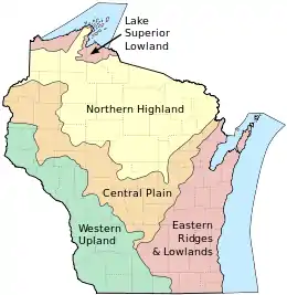
With its location between the Great Lakes and the Mississippi River, Wisconsin is home to a wide variety of geographical features. The state is divided into five distinct regions: the Lake Superior Lowland, Northern Highland, Central Plain, Easter Ridges & Lowlands, and the Western Upland.
Lake Superior Lowland and Northern Highland
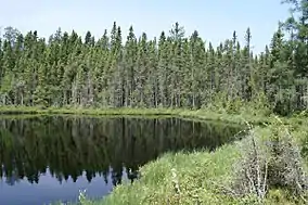
In the north, the Lake Superior Lowland occupies a belt of land along Lake Superior. Just to the south, the Northern Highland has massive mixed hardwood and coniferous forests including the 1,500,000 acres (6,100 km2) Chequamegon-Nicolet National Forest, as well as thousands of glacial lakes, and the state's highest point, Timms Hill.
Central Plain and Western Upland
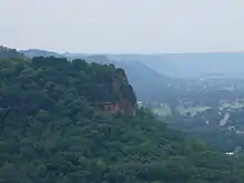
In the middle of the state, the Central Plain has some unique sandstone formations like the Dells of the Wisconsin River in addition to rich farmland. In the southwest, the Western Upland is a rugged landscape with a mix of forest and farmland, including many bluffs on the Mississippi River. This region is part of the Driftless Area, which also includes portions of Iowa, Illinois, and Minnesota. This area was not covered by glaciers during the most recent ice age, the Wisconsin Glaciation. Overall, 46% of Wisconsin's land area is covered by forest. Langlade County has a soil rarely found outside of the county called Antigo silt loam.[4]
Eastern Ridges and Lowlands
The Eastern Ridges and Lowlands region in the southeast is home to many of Wisconsin's largest cities. The ridges include the Niagara Escarpment that stretches from New York, the Black River Escarpment and the Magnesian Escarpment.[5][6][7] The bedrock of the Niagara Escarpment is dolomite, while the two shorter ridges have limestone bedrock.
Rivers
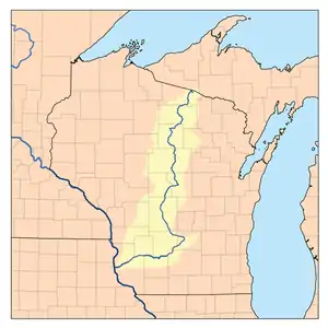
Wisconsin is bordered by the Mississippi River and St. Croix River in the west. Wisconsin has more than 12,000 named rivers and streams, totaling 84,000 miles (135,000 km).[8] Important rivers include: Mississippi River, Wisconsin River, Menominee River, Fox River, and the St. Croix River. The Baraboo River is one of the longest free flowing waterways in the United States.[9]
Lakes
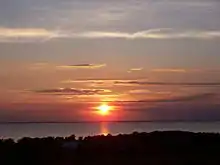
Wisconsin is bordered by Lake Superior in the north, and Lake Michigan in the east.[10] Wisconsin has over 15,000 named lakes, totaling about 1 million acres (4,046 km2), and 6.4 million acres (25,899 km2) of Lake Superior and Lake Michigan.[11] Lake Winnebago is the largest inland lake, totaling over 137,700 acres (557 km2), and 88 miles (142 km) of shoreline. Other important lakes include: Devil's Lake, Lake Wisconsin, and Castle Rock Lake.
Islands

The Great Lakes account for a large amount of the named islands in Wisconsin. Many surround the Door Peninsula in Lake Michigan, or are part of the Apostle Islands in Lake Superior.[12] The Mississippi River also has a multitude of islands on the state's western boundary. Inland lakes and rivers contain the rest of the islands of Wisconsin. Lakes such as Beaver Dam Lake, Fox Lake, and Lake Winnebago have an abundance of islands. Large rivers like the Wisconsin River and Fox River have many islands as well. Some islands in Wisconsin are populated, with the most notable being:
Protected areas of Wisconsin
Wisconsin has 66 state parks, covering more than 60,570 acres (245.1 km2). Several state parks have been recognized on a national level, including:[1]
- Chippewa Moraine State Recreation Area
- Devil's Lake State Park
- Interstate State Park
- Wyalusing State Park
Areas under the management of the National Park Service include the following:[13]
- Apostle Islands National Lakeshore along Lake Superior
- Ice Age National Scenic Trail
- North Country National Scenic Trail
- Saint Croix National Scenic Riverway
There is one national forest managed by the U.S. Forest Service in Wisconsin, Chequamegon-Nicolet National Forest.
References
- Spoolman, Scott (2018-04-12). Wisconsin State Parks: Extraordinary Stories of Geology and Natural History. Wisconsin Historical Society. ISBN 978-0-87020-850-8.
- Benedetti, Michael. "Climate of Wisconsin". The University of Wisconsin–Extension. Archived from the original on January 17, 2013. Retrieved March 16, 2007.
- "Monthly Averages for Superior, WI (54880)—weather.com". Archived from the original on November 3, 2013. Retrieved May 29, 2013.
- United States Department of Agriculture Natural Resources Conservation Service (April 1999). "Wisconsin State Soil: Antigo Silt Loam" (PDF). Archived (PDF) from the original on May 16, 2017. Retrieved October 17, 2017. Cite journal requires
|journal=(help) - Lawrence Martin (1965). The physical geography of Wisconsin. University of Wisconsin Press. p. 247. ISBN 978-0-299-03475-7. Retrieved September 14, 2010.
Black River Escarpment.
- "The Eastern Ridges and Lowlands of Wisconsin". Wisconsin Online. Archived from the original on February 9, 2001. Retrieved September 14, 2010.
- Webcitation.org, Wisconline.com, September 14, 2010.
- "Rivers | Wisconsin DNR". dnr.wisconsin.gov. Retrieved 2020-10-30.
- "River Facts and Resources | Wisconsin DNR". dnr.wisconsin.gov. Retrieved 2020-10-30.
- "About Wisconsin's Great Lakes | Wisconsin DNR". dnr.wisconsin.gov. Retrieved 2020-10-30.
- "Wisconsin Water Facts – Wisconsin Water Library". Retrieved 2020-10-30.
- "Door Co. Map" (PDF). Door Co. Dept. of Transportation. Retrieved 29 December 2020.
- "Wisconsin". National Park Service. Archived from the original on July 25, 2008. Retrieved July 17, 2008.