West Allis, Wisconsin
West Allis is a city in Milwaukee County, Wisconsin, United States. A suburb of Milwaukee, it is part of the Milwaukee metropolitan area. The population was 60,411 at the 2010 census.
West Allis, Wisconsin | |
|---|---|
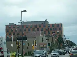 Downtown West Allis | |
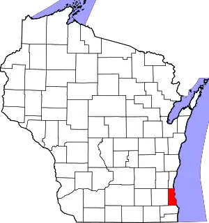
 Location of West Allis in Milwaukee County, Wisconsin. | |
 West Allis, Wisconsin Location in the United States | |
| Coordinates: 43°0′29″N 88°1′6″W | |
| Country | |
| State | |
| County | Milwaukee |
| Government | |
| • Type | Mayor-Council |
| • Mayor | Dan Devine |
| Area | |
| • Total | 11.40 sq mi (29.54 km2) |
| • Land | 11.38 sq mi (29.48 km2) |
| • Water | 0.02 sq mi (0.06 km2) |
| Elevation | 728 ft (222 m) |
| Population | |
| • Total | 60,411 |
| • Estimate (2019)[4] | 59,890 |
| • Density | 5,262.28/sq mi (2,031.73/km2) |
| Time zone | UTC−6 (Central (CST)) |
| • Summer (DST) | UTC−5 (CDT) |
| Zip Code | 53214, 53222, 53227 |
| Area code(s) | 414 |
| FIPS code | 55-85300[5] |
| GNIS feature ID | 1576439[2] |
| Website | www |
History
The name West Allis derives from Edward P. Allis,[6] whose Edward P. Allis Company was a large Milwaukee-area manufacturing firm in the late 19th century. In 1901, the Allis company became Allis-Chalmers, and in 1902 built a large new manufacturing plant west of its existing plant. The locale in which the new plant was constructed was at the time called North Greenfield, and prior to the 1880s had been called Honey Creek. With the building of the western Allis plant, the area was incorporated as the Village of West Allis, and it became the City of West Allis in 1906.[7]
With the presence of Allis-Chalmers, the largest manufacturer in the area, West Allis became the largest suburb of Milwaukee in the early 20th century.[8] After that, West Allis grew quickly. Between 1910 and 1930, its population grew fivefold.[9] After 1965, the Allis-Chalmers company's fortunes had turned. By 1985, Allis-Chalmers's global workforce had shrunk to 13,000 from its peak of 31,000.[10] Since then, West Allis has had some success attracting other employers, such as Quad Graphics.[11]
Geography
West Allis is located at 43°0′29″N 88°1′6″W (43.00, −88.02).[12] The upper courses of the Root and Kinnickinnic Rivers flow through the city. According to the United States Census Bureau, the city has a total area of 11.41 square miles (29.55 km2), of which, 11.39 square miles (29.50 km2) is land and 0.02 square miles (0.05 km2) is water.[13]
Climate
| ||||||||||||||||||||||||||||||||||||||||||||||||||||||||||||||||||||||||||||||||||||||||||||||||||||||||||||||||||||||||||||
Demographics
| Historical population | |||
|---|---|---|---|
| Census | Pop. | %± | |
| 1910 | 6,645 | — | |
| 1920 | 13,745 | 106.8% | |
| 1930 | 34,671 | 152.2% | |
| 1940 | 36,364 | 4.9% | |
| 1950 | 42,959 | 18.1% | |
| 1960 | 68,157 | 58.7% | |
| 1970 | 71,723 | 5.2% | |
| 1980 | 63,982 | −10.8% | |
| 1990 | 63,221 | −1.2% | |
| 2000 | 61,254 | −3.1% | |
| 2010 | 60,411 | −1.4% | |
| 2019 (est.) | 59,890 | [4] | −0.9% |
| U.S. Decennial Census[15] | |||
2010 census
As of the census[3] of 2010, there were 60,411 people, 27,454 households, and 14,601 families living in the city. The population density was 5,303.9 inhabitants per square mile (2,047.8/km2). There were 29,353 housing units at an average density of 2,577.1 per square mile (995.0/km2). The racial makeup of the city was 86.7% White, 3.6% African American, 1.1% Native American, 2.0% Asian, 3.6% from other races, and 2.9% from two or more races. Hispanic or Latino of any race were 9.6% of the population.
There were 27,454 households, of which 25.8% had children under the age of 18 living with them, 36.3% were married couples living together, 11.9% had a female householder with no husband present, 5.0% had a male householder with no wife present, and 46.8% were non-families. 38.6% of all households were made up of individuals, and 13.3% had someone living alone who was 65 years of age or older. The average household size was 2.17 and the average family size was 2.90.
The median age in the city was 37.7 years. 20.5% of residents were under the age of 18; 8.3% were between the ages of 18 and 24; 30.1% were from 25 to 44; 26.5% were from 45 to 64; and 14.6% were 65 years of age or older. The gender makeup of the city was 49.0% male and 51.0% female.
2000 census
As of the census[5] of 2000, there were 61,254 people, 27,604 households, and 15,375 families living in the city. The population density was 5,397.6 people per square mile (2,083.7/km2). There were 28,708 housing units at an average density of 2,529.7 per square mile (976.6/km2). The racial makeup of the city was 94.03% White, 1.34% African American, 0.70% Native American, 1.33% Asian, 0.02% Pacific Islander, 1.18% from other races, and 1.41% from two or more races. Hispanic or Latino of any race were 3.52% of the population.
There were 27,604 households, out of which 25.5% had children under the age of 18 living with them, 41.2% were married couples living together, 10.6% had a female householder with no husband present, and 44.3% were non-families. 37.3% of all households were made up of individuals, and 14.0% had someone living alone who was 65 years of age or older. The average household size was 2.19 and the average family size was 2.92.
In the city, the population was spread out, with 21.5% under the age of 18, 8.4% from 18 to 24, 32.3% from 25 to 44, 20.5% from 45 to 64, and 17.2% who were 65 years of age or older. The median age was 38 years. For every 100 females, there were 93.0 males. For every 100 females age 18 and over, there were 90.0 males.
The median income for a household in the city was $39,394, and the median income for a family was $50,732. Males had a median income of $36,926 versus $26,190 for females. The per capita income for the city was $20,914. About 4.6% of families and 6.5% of the population were below the poverty line, including 9.0% of those under age 18 and 5.6% of those age 65 or over.
Arts and culture
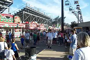
The Wisconsin State Fair Park, which includes the Milwaukee Mile and is the site of the annual Wisconsin State Fair, is located in West Allis.
The West Allis Post Office contains two oil on canvas murals, Wisconsin Wild Flowers – Spring and Wisconsin Wild Flowers – Autumn, painted in 1943 by Frances Foy. Murals were produced from 1934 to 1943 in the United States through the Section of Painting and Sculpture, later called the Section of Fine Arts, of the Treasury Department.
Candy Cane Lane runs through Oklahoma and Montana Avenues and 92nd to 96th Street. Residents have been creating elaborate Christmas display since 1984, bringing bumper-to-bumper traffic through the streets on December nights. The festive event has raised over $2.2 million for the MACC Fund.[16]
On June 15, 2006, the city celebrated its 100th anniversary. The celebration included a parade, fireworks and a family festival.[17]
Sports
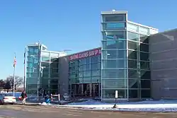
Pettit National Ice Center is one of only two indoor speed skating rinks in the United States.
Transportation
West Allis is served by MCTS Routes 28, 44U, 51, 53, 54, 56, 64, 67, 76, and BlueLine.
Interstate 94 and Interstate 41/Interstate 894 also run through the city.
Education
The schools in the West Allis – West Milwaukee School District:
- Franklin Elementary School
- Hoover Elementary School
- Horace Mann Elementary School
- Irving Elementary School
- Jefferson Elementary School
- Longfellow Elementary School
- Madison Elementary School
- Mitchell Elementary School
- Pershing Elementary School
- Walker Elementary School
- Wilson Elementary School
- Frank Lloyd Wright Intermediate School
- Lane Intermediate School
- West Milwaukee Intermediate School
- West Allis Central High School
- Nathan Hale High School
- James E. Dottke High School
The Wisconsin Evangelical Lutheran Synod has two grade school in West Allis:
Government
West Allis is represented by Jim Sensenbrenner (R) in the United States House of Representatives, and by Ron Johnson (R) and Tammy Baldwin (D) in the United States Senate. Tim Carpenter (D) and Leah Vukmir (R) represent West Allis in the Wisconsin State Senate, and Daniel Riemer (D), Rob Hutton (R), and Joe Sanfelippo (R) represent West Allis in the Wisconsin State Assembly.
Notable businesses
- Allis-Chalmers, since closed
- Siemens Power Corporation, now on former Allis-Chalmers grounds
- Quad Graphics, printer
- WDJT-TV (Channel 58, CBS), WMLW-TV (Channel 49, IND), WBME-CD (Channel 41, Me-TV) and WYTU-LD (Channel 63, Telemundo), Weigel Broadcasting stations with studios located on South 60th Street in a former Allis-Chalmers building
- West Allis Speedskating Club
Notable people
- Jared Abbrederis (1990-) – National Football League player
- Arthur J. Balzer (1895-1962) – Wisconsin State Representative
- Gary J. Barczak (1939-)– Wisconsin State Representative
- Jeannette Bell (1941-) – former Mayor of West Allis and legislator
- Dave Cieslewicz (1959-)– former Mayor of Madison, Wisconsin
- Jeffrey Dahmer (1960-1994) – serial killer
- Terry A. Davis (1969-2018) – computer programmer
- Tighe Dombrowski (1982-) – professional soccer player
- Julius Fiege (1861-1918) – Wisconsin State Representative
- Jerry Golsteyn (1954-) – NFL player
- Jaida Essence Hall - drag queen
- George C. Hinkley (1862-1936) – Wisconsin State Representative
- Martin F. Howard (1892-1969)– Wisconsin State Representative
- Robert T. Huber (1920-1991)– Wisconsin legislator
- Donald J. Hying (1963-) – Roman Catholic bishop
- Jeff Jagodzinski (1963-) – NFL assistant coach
- Dan Jansen (1965-) – world champion speedskater, Olympic gold medalist
- Richard A. Knobloch (1918-2001) – U.S. Air Force general
- Mike Krsnich (1931-2011) – MLB player
- Rocky Krsnich (1927-2019) – MLB player
- Harvey Kuenn (1930-1988) – MLB player and manager
- Liberace (1919-1987) – entertainer and pianist
- James Melka (1962-) – NFL player
- Dawn Miceli – comedian, podcast host, and member of Rasputina (band)
- Delbert Miller – Wisconsin legislator
- Chellsie Memmel (1988-) – world champion gymnast, 2008 Olympic silver medalist
- Billy Mitchell (1879-1936)– distinguished U.S. Army general
- Eugene A. Phalen (1876-1940)– Wisconsin legislator
- Gottfried Schloemer (1842-1921) – designer of world's first gasoline automobile
- Tony Staskunas (1961-) – Wisconsin legislator
- Owen Turtenwald (1989-)– Hall of Fame "Magic the Gathering" player
- Nick Pearson (1979-) – Olympic athlete, national champion speedskater
- Ricky Wagner –(1989-) Wisconsin Badgers, NFL player
- Jane Wiedlin (1958-)– rhythm guitarist of The Go-Go's, actress
- Tony Willman (1907-1941)– professional race car driver
- Jerry L. Wing (1923-1994) – Wisconsin businessman and politician
- Gabriel Zophy (1869-1947) – Wisconsin politician
See also
References
- "2019 U.S. Gazetteer Files". United States Census Bureau. Retrieved August 7, 2020.
- "US Board on Geographic Names". United States Geological Survey. 2007-10-25. Retrieved 2008-01-31.
- "U.S. Census website". United States Census Bureau. Retrieved 2012-11-18.
- "Population and Housing Unit Estimates". United States Census Bureau. May 24, 2020. Retrieved May 27, 2020.
- "U.S. Census website". United States Census Bureau. Retrieved 2008-01-31.
- Chicago and North Western Railway Company (1908). A History of the Origin of the Place Names Connected with the Chicago & North Western and Chicago, St. Paul, Minneapolis & Omaha Railways. p. 138.
- "West Allis History". Archived from the original on 2013-07-21. Retrieved 2011-09-07.
- Gurda, John (1999). The Making of Milwaukee. Milwaukee County Historical Society. p. 185.
- Gurda, John (1999). The Making of Milwaukee. Milwaukee County Historical Society. p. 247.
- "Allis-Chalmers A Shell Of Its Former Self". Chicago Tribune. Retrieved 8 September 2015.
- "West Allis backs Quad/Graphics Plan". Milwaukee Journal-Sentintel. Retrieved 8 September 2015.
- "US Gazetteer files: 2010, 2000, and 1990". United States Census Bureau. 2011-02-12. Retrieved 2011-04-23.
- "US Gazetteer files 2010". United States Census Bureau. Retrieved 2012-11-18.
- "NASA Earth Observations Data Set Index". NASA. Retrieved 30 January 2016.
- "Census of Population and Housing". Census.gov. Retrieved June 4, 2015.
- Adriana Mendez (Nov 23, 2018). "Candy Cane Lane returns to West Allis". TMJ4.
- West Allis Centennial Celebration
- "Good Shepherd Lutheran".
- "Welcome to Lamb of God Lutheran School".
