Google Street View in North America
In North America, Google Street View is available in Canada, the United States, Mexico, Guatemala and Greenland, and limited coverage in some more areas.
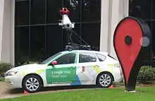
Background
United States
The United States was the first country to have Google Street View images and was the only country with images for over a year following introduction of the service on May 25, 2007. Early on, most locations had a limited number of views, usually constrained to the city limits and only including major streets, and they only showed the buildings up to a certain height. Few suburbs or other nearby cities were included.
After the first few sets of introductions, image collections from cities added were more detailed, often including every side street, especially in areas closer to the center of the city. More suburbs and other nearby cities were included.
The coverage of various cities has in many cases, subsequently been enlarged and improved, but not necessarily on the same date as new cities have been added. Improvements have included the additions of streets in neighborhoods where previously only main roads had been covered, expansions to more suburbs, and views to the sky where previously only views to a certain height were provided.
Initially when a group of cities were added, only those cities and their own suburbs would be a part of the image collection. However June 10, 2008 introductions also included cities in covered areas without camera icons and isolated from any other camera icons. Many more cities were added without icons on August 4, when the only U.S. city added with an icon was New Orleans.
On November 9, 2009, parts of Hawaii were added, and coverage of the United States was also further expanded, although some key areas had yet to be added. With the addition of Hawaii, all fifty states are now represented in Street View.[1]
On July 2, 2013, high-definition images, at least 99% of which has been taken since early 2011, were added to major portions of all fifty states, including those that have had no HD images up to that point.
The last state or territory of the US to get coverage was Puerto Rico on December 14, 2016.
Canada
Street View in Canada began on October 7, 2009. On this day, Street View was made available for several large Canadian cities, as well as Banff National Park and Whistler, British Columbia (one of the sites from the 2010 Winter Olympics).[2] This was after long anticipation of the feature in the country. Street View cars had been spotted as early as 2007.[3]
On December 2, 2009, nine more Canadian cities were added, from east to west St. John's, Sherbrooke, Sudbury, London, Winnipeg, Saskatoon, Edmonton and Victoria.[4]
On February 10, 2010, many more areas of Canada (barring extremely northern and rural areas) were added.[5] Of note, ski runs on Whistler Blackcomb Resort is also covered in this update.[5] As of 2013 the northernmost community imaged is the Arctic island community of Cambridge Bay, Nunavut. As of April 2014 the only Canadian urban areas whose images have not been uploaded are the urban areas within the Labrador region of Newfoundland and Labrador.
On October 10, 2012, street view images in many parts of Canada were updated and some new images of parks, trails, university campuses and zoos were added.[6]
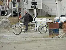
On March 19, 2013, the Nunavut city of Iqaluit was imaged. Rather than shipping a car or using a trike the city will be imaged using backpack mounted cameras over a period of three days. One of the people involved, Chris Kalluk, was responsible for Google mapping Cambridge Bay, his home town.[7] Iqaluit officially appeared on Street View on July 9, 2013, coinciding with Nunavut Day.[8] With the inclusion of Iqaluit all provincial/territorial capitals have been imaged and are available on Street View.
In 2013, Parks Canada began a 2-year collaboration with Google to provide street view images of the most iconic parks and heritage places in Canada.[9] In November 2013, the first set of images were released.[10]
In 2014, Street View imagery of Fort McMurray was uploaded. The northern Alberta city was the last remaining major Canadian urban area to be imaged. However, as of July 2015, Street View imagery has yet to be uploaded for any communities in Labrador.
Mexico
In Mexico, first reports of sightings came in from Tijuana in July 2007 making the first city in Latin America and now Google Street View cars are being spotted in many Mexican states. On November 9, 2009, Street View was made available in cities of Mexico, including Mexico City, Guadalajara, Monterrey, Puebla, Cancún and Puerto Vallarta.[11]
On February 10, 2010, more places were added.
On April 15, 2010, more areas of Mexico were uploaded. Although complete coverage has not yet occurred (in some cities only main streets are imaged), numerous locations including communities in Baja California and Ciudad Juárez now had extensive street-level coverage with this update.
In August 2012, panoramic views of 30 Mesoamerican archaeological sites were added.[12]
Filming of Street View in Mexico began in October 2008.
Central America
Guatemala was added on April 25, 2017.
Some landmarks in Costa Rica were added on July 17, 2018.
Street images will be added in Costa Rica in 2021.
Caribbean
Martinique was added on December 11, 2013 using backpack mounted cameras.
Bermuda was added in 2015 and U.S. Virgin Islands and Puerto Rico were added in 2016
Curaçao was added in 2018
Dominican Republic and Barbados were added in 2020
North Atlantic islands
Selected parts of Greenland were added on February 18, 2015. They cover some villages and some boat trips. Greenland has no roads between villages. The images were taken from boats, cars, all-terrain vehicles, hiking backpacks and more modes.
Bermuda was added in 2015, in May underwater views outside the island, in September locations on land.
Saint Pierre and Miquelon was added on May 17, 2017.
Timeline of introductions
Areas included
Reference:[13]
 Barbados
Most towns, cities, villages, major and rural roads
 Denmark
| Municipality | Major cities/areas |
|---|---|
| Kujalleq | Qaqortoq, Narsaq, Narsarsuaq, Qassiarsuk |
| Northeast Greenland | Daneborg |
| Qaasuitsup | Aasiaat, Akunnaaq, Ikamiut, Ikerasaarsuk, Ilimanaq, Ilulissat, Niaqornaarsuk, Oqaatsut, Qasigiannguit, Qeqertaq, Qeqertarsuaq, Saqqaq, Siorapaluk, Qaanaaq, Uummannaq |
| Qeqqata | Itilleq, Kangerlussuaq, Maniitsoq, Sarfannguit, Sisimiut A road between Kangerlussuaq and the ice sheet. A snow mobile ride between Sisimiut and Kangerlussuaq. |
| Sermersooq (west) | Nuuk, Paamiut |
| Sermersooq (east) | Ittoqqortoormiit, Kulusuk, Tasiilaq |
and more locations and water views
.svg.png.webp) Canada
Canada
Most towns, cities, villages, major and rural roads
 Costa Rica
Landmarks including Institute of Technology, Isla del Coco, Juan Santamaría International Airport, Museo Nacional de Costa Rica, Playa Grande, and more. Some streets of Heredia.
 France
| State | Major cities/areas |
|---|---|
| Some hiking paths | |
| Saint Pierre and Miquelon | Miquelon-Langlade, Saint Pierre |
 Guatemala
Major cities, and major roads
 Mexico
 Panama
- Some roads and streets in Panama City
- Part of road 1
 United Kingdom
| Area | Site |
|---|---|
| On land | Major streets and roads |
| Underwater, in the ocean | 32°29′01″N 64°41′09″W, 32°13′47″N 64°51′56″W, 32°14′30″N 64°49′54″W, 32°20′49″N 64°38′59″W |
Most streets and roads
 United States
Most towns, cities, villages, major and rural roads
Countries without any coverage
Central America:
![]() Belize,
Belize,
![]() El Salvador,
El Salvador,
![]() Honduras,
Honduras,
![]() Nicaragua,
Nicaragua,
![]() Panama
Panama
Caribbean:
![]() Antigua and Barbuda,
Antigua and Barbuda,
![]() Bahamas,
Bahamas,
![]() British Virgin Islands,
British Virgin Islands,
![]() Cuba,
Cuba,
![]() Dominica,
Dominica,
![]() Grenada,
Grenada,
![]() Haiti,
Haiti,
![]() Jamaica,
Jamaica,
![]() St. Kitts and Nevis,
St. Kitts and Nevis,
![]() Saint Lucia,
Saint Lucia,
![]() St. Vincent and the Grenadines,
St. Vincent and the Grenadines,
![]() Trinidad and Tobago
Trinidad and Tobago
All these countries have user-generated panorama photos called Photo Spheres, similar to the Street View photos, accessible within Google Maps.
Competing products
References
- Melahn, Laura. "Official Google Blog: Fifty states of Street View". Googleblog.blogspot.com. Retrieved February 7, 2010.
- "Google Street View goes live in Canadian Cities". CBC. October 8, 2009. Retrieved February 22, 2013.
- Cacho, Maurice (April 23, 2014). "New Google Street View feature lets you go back in time". CTV News. Retrieved September 4, 2014.
- "Google Street View adds 9 Canadian Cities". CBC. December 2, 2009. Retrieved February 22, 2013.
- "Google Street View expands across Canada". CBC. Feb 9, 2010. Retrieved February 22, 2013.
- Ballingall, Alex (October 11, 2012). "Google StreetView expands into parks, zoos, campuses, and tourist sites". Toronto Star. Retrieved February 22, 2013.
- "NunatsiaqOnline 2013-03-14: NEWS: Google Maps to put Iqaluit on street view". nunatsiaqonline.ca.
- "Google Street View captures Iqaluit". CBC. July 9, 2013. Retrieved September 4, 2014.
- "Explore Canada's natural and historic treasures with Street View for Google Maps". Parks Canada. 2014-04-04. Archived from the original on August 5, 2014. Retrieved September 4, 2014.
- "Canada's parks and historic sites now on Google Street View". CBC. November 20, 2013. Retrieved September 4, 2014.
- "México ya es accesible, calle por calle, en Internet". Informador.com.mx. Retrieved 2010-08-27.
- "Google Street View now available for Mexico archaeological sites – latimes.com". Latimesblogs.latimes.com. 2012-08-22. Retrieved 2013-01-19.
- https://www.google.com/maps/